.gif.a8150e126cebc480193fad2934fe975c.gif)
Torch Tiger
-
Posts
16,338 -
Joined
-
Last visited
Content Type
Profiles
Blogs
Forums
American Weather
Media Demo
Store
Gallery
Everything posted by Torch Tiger
-
.thumb.gif.f92b16c631a1d15d405ed77b33f0710d.gif)
December 2025 regional war/obs/disco thread
Torch Tiger replied to Torch Tiger's topic in New England
Congrats -
December 2025 regional war/obs/disco thread
Torch Tiger replied to Torch Tiger's topic in New England
Hopefully less dynamics as early and a few more ticks north -
December 2025 regional war/obs/disco thread
Torch Tiger replied to Torch Tiger's topic in New England
Borderline...keep on pushing those temps.
-
December 2025 regional war/obs/disco thread
Torch Tiger replied to Torch Tiger's topic in New England
Time to fire up a thread! Its a lock! -
December 2025 regional war/obs/disco thread
Torch Tiger replied to Torch Tiger's topic in New England
-
December 2025 regional war/obs/disco thread
Torch Tiger replied to Torch Tiger's topic in New England
too amped? -
December 2025 regional war/obs/disco thread
Torch Tiger replied to Torch Tiger's topic in New England
yeah it looks like exactly what you'd expect for 12/2. -
December 2025 regional war/obs/disco thread
Torch Tiger replied to Torch Tiger's topic in New England
yeah ggem and gfs op really amped up. snow/mix/rain -
Epic, so many memories there 1989 all over
-
December 2025 regional war/obs/disco thread
Torch Tiger replied to Torch Tiger's topic in New England
Looks 12/ 2007 ish -
November 2025 general discussions and probable topic derailings ...
Torch Tiger replied to Typhoon Tip's topic in New England
Some said 40's...cold press..models shifting...we just don't know...yada -
November 2025 general discussions and probable topic derailings ...
Torch Tiger replied to Typhoon Tip's topic in New England
Some said it wouldnt happen...some were wrong -
November 2025 general discussions and probable topic derailings ...
Torch Tiger replied to Typhoon Tip's topic in New England
Near 60 at work in Chelmsford. Gorgeous! -
December 2025 regional war/obs/disco thread
Torch Tiger replied to Torch Tiger's topic in New England

-
December 2025 regional war/obs/disco thread
Torch Tiger replied to Torch Tiger's topic in New England
before reading, initial instinct was 2011-2012 lol. that's wild, forgot that happened. -
Best was Patrick o'hearn downhill racer
-
November 2025 general discussions and probable topic derailings ...
Torch Tiger replied to Typhoon Tip's topic in New England
yeah it's disappointing to see everything slip away like that. Especially with the tremendous SSW hype and etc. -
November 2025 general discussions and probable topic derailings ...
Torch Tiger replied to Typhoon Tip's topic in New England
without a more favorable pattern, looks unlikely. Unless you mean far nne (threats) -
November 2025 general discussions and probable topic derailings ...
Torch Tiger replied to Typhoon Tip's topic in New England
ensemble blends are fine to get a general idea /big picture
-
November 2025 general discussions and probable topic derailings ...
Torch Tiger replied to Typhoon Tip's topic in New England
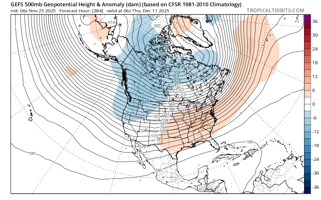
6z gefs milder in the extended. Canada is cold but more normal at end, with S US roasting. Concerns -
December 2025 regional war/obs/disco thread
Torch Tiger replied to Torch Tiger's topic in New England
decent blocking in various degrees showing up D10+ across Eastern EU/Russia/Scandanavia. -
December 2025 regional war/obs/disco thread
Torch Tiger replied to Torch Tiger's topic in New England
big 'un, cne too -
December 2025 regional war/obs/disco thread
Torch Tiger replied to Torch Tiger's topic in New England
18z gfs has a nce snower for NNE 12/3