Torch Tiger
-
Posts
14,925 -
Joined
-
Last visited
Content Type
Profiles
Blogs
Forums
American Weather
Media Demo
Store
Gallery
Everything posted by Torch Tiger
-
Yeah much more notably dry here, 50's. Sucks
-
yeah, way too dry. Nice though, no doubt.
-
A-
-
what more could a weenie want?
-
more impressive that we're still 2-3 weeks? from peak temps
-
will be a nowcast, I wouldn't rule out something. A few mesos kinda hit on EMA from here down to your hood, to the Cape. (as you probably saw)
-
tbh I am really sensitive to any stinging/blood-sucking insects, and the usual allergies. epipen. Carhartt/Hoodie until it's like 95/75 or unbearable
-
shorts though? That's brutal. I hate that "eaten alive" feeling, so wear the same thing/attire year-round. T-shirt when it's 90 or 100
-
Yeah, a real mosquito summer out there. Be sure to wear plenty of layers and protect yourself from that WNV.
-
...Parts of the Northeast... Storms may be ongoing at the beginning of the period across the Northeast as a mid-level shortwave trough shifts southeast. These storms could be marginally severe with some damaging wind threat. In the wake of this convection, very strong to extreme instability is expected to build into the Northeast, but very warm lower tropospheric temperatures and building heights aloft should suppress additional afternoon thunderstorms. Damn. Love that extreme wording though
-
Love that feeling when you walk out the door and it feels like exiting FLL airport! Just hits you like a wall, no escape
-
Love those 90 by 9am mornings! When you can really enjoy the heat for hours and hours the entire day. LFG!
-
Yeah I suppose the speed,track etc. of the MCS/convection in the morning plays a big part in how models heat us up later
-
Has it? I thought it was advertised an 88-93 type day
-
-
hang on branches and take them down, yea wow pushing for content there........wild damage
-
NJ/PA south every time on this thing. The organized stuff SW of "us" will rob all that energy Kinetics and overall environment is/are more friendly there, too.
-
that's true
-
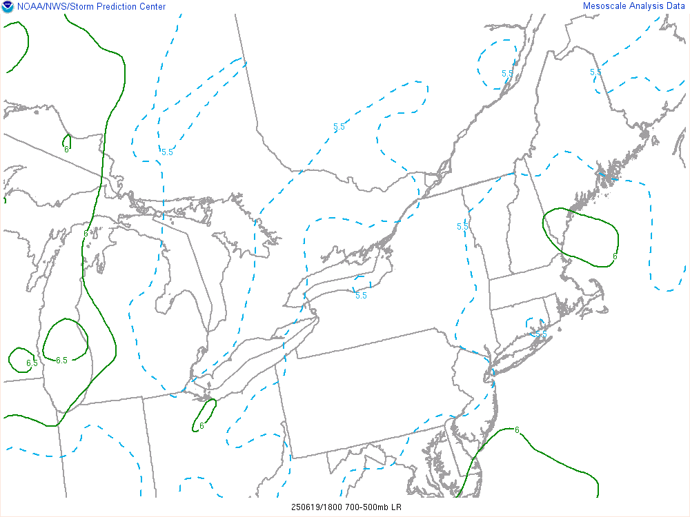
and I'm sure lapse rates aren't a huge deal TBH, 6C or 6.5C/km very doable 90/70ish. But you'd need slightly more dynamics, forcing, or shear. probably two of those three, to offset not having that bouyancy. Stronger forcing would have at least organized some of this stuff a bit more. Not great timing at all.
-
Yeah, agree about those lapse rates; big-time bummer there and not sure NWS BOS or ALB discussed it at all. I was really expecting to see those dark greens? at least, 6.5 C/km or higher. Should have checked upstream soundings like you did OTOH stuff will pop more easily, less lid? I suppose. At least there's weaker stuff :/
-
VG/VG+ job thus far from mesos, clearly hit the 19-23z for west/central. it's just too bad everything looks anemic, shallow. ":/
-
svr warning for that E NY/W MA cell.
-
hey, at least there's a few rain showers/storms around for you central and western folks. congrats
-
ML lapse rates look like garbage. I get it now, ew