
.gif.a8150e126cebc480193fad2934fe975c.gif)
Torch Tiger
-
Posts
15,990 -
Joined
-
Last visited
Content Type
Profiles
Blogs
Forums
American Weather
Media Demo
Store
Gallery
Everything posted by Torch Tiger
-
Dec. 24th-28th 2008
-
I liked 2010. Remember closing on my house Jan 1st 2010. days of mood snow, totalling around 8"
-
Perhaps, but that Mar.-May was even better. Winters as a whole suck, even warm ones.
-
#1
-
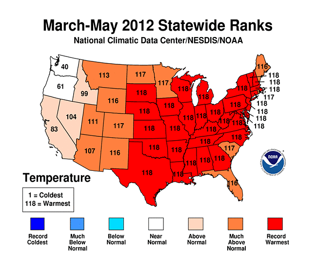
2012 is an honorable mention. Easily the best warm season ever
-
The Great Torch of 2012 is an honorable mention, though not a single event.
-
I don't remember the '89 one, was on Cape Cod. However August 1992 in Falmouth MA, around the 12th? was pretty good. Lots of hail and lightning strikes for several hours. Wind damage, flooding. Top 20 for me in SNE, especially on that broken wx island.
-
Many there that would shape any wx weenie. For me..Bob, Gloria, June 95, 1993 superstorm, Aug 2000 (I was older but, the first time driving through a nocturnal supercell was pretty scary)
-
Dorian does make a run at the Gulf after all. Too bad it's near Maine
-
This scrapercane is annoying. Sorry, /rant
-
A redux of Hazel or King would set this forum on fire
-
too bad the water was/is turned over
-
Drama.
-
Eastern was better
-
That makes absolutely no sense, but you are consistent anyway.
-
The weather..:D Meanwhile not to worry folks, the 12z NAM has a great handle on the situation.
-
days and days
-
Sept 25th
-
Yeah but but the 18z Mongolian has it wsw into Florida
-
Where is the moderation in the main thread, when it's really needed? :/
-
Only one area??
-
What a weeniecane
-
drinking the model kool-aid
-
It's the same as most other msg boards and social media. The main thread: it's always a few enlightening posts surrounded by 95% filler, you just have to take away what you like to and sift through the rest.
-
It's always been that way, a lot of groupthink and pig-piling on unpopular opinions and a few over-sensitive types to boot
.thumb.gif.f92b16c631a1d15d405ed77b33f0710d.gif)


