

Torch Tiger
-
Posts
13,259 -
Joined
-
Last visited
Content Type
Profiles
Blogs
Forums
American Weather
Media Demo
Store
Gallery
Posts posted by Torch Tiger
-
-
14 minutes ago, Hoth said:
I don't think it's anything too extraordinary. It's been riding along the Gulf Stream. Also, being caught up in the westerlies I think lessens effective shear. There was a hurricane that held cat 4 strength some years back in that area. Forget which one it was, but that was something to behold.
-
this looks like an alright signal for some EC tropical impacts. Not saying SNE specific but not all dissimilar to some of the analog years presented by the NHC esrlier this year.
Of course we need a storm or two to track, so we'll see. Not a bad look to enter September.
.thumb.gif.f0aacb4b4fe00f003eb9b88535e20c95.gif)
-
 1
1
-
-
It's been quiet so far but recent active years have shown the same cards.
-
Be vigilant
-
On 8/11/2019 at 12:33 PM, CoastalWx said:
Non existent for SNE this year. Like most years. Doesn’t look like a pattern conducive for a SNE hit or even glance.
Thank you, I am notifying folks
-
Aug ~20th-25th should bring the seasonal ramp up.
-
The CV disturbance has potential, hopefully it runs silent and deep and develops later than sooner...
-
1 hour ago, LongBeachSurfFreak said:
Look at that path leading right to NE. Given the right circumstances this could be the year for a big one.
Would be better if we had anomalously warm waters NE of us, though, promoting slightly higher pressure and maybe stronger blocking episodes. That is nitpicky..
-
-
44 minutes ago, Hoth said:
Found it. Cane footage starts around 2:30.
Yeah I watched that one. It looks like storm footage from Newport, RI, then the aftermath in BID. Iirc BID gusted ~125, Newport was maybe 100ish
-
1
-
-
2 hours ago, Hoth said:
That was awesome. There's a video of Bob from Block Island floating around that's pretty epic too.
Not sure if I have seen that, will check it out.
-
-
love this, looks like 60-70 sustained. Dartmouth MA just missed the strongest winds by 30-60 mi but the fading eye went overhead
-
 1
1
-
-
12 hours ago, Hoth said:
Nice find. After seeing the damage in Harwich from a minor tornado, imagine the nightmare that will be New England when the next major cane comes roaring through. Hope the utilities have a big sinking fund and their disaster insurers have reinsurance.
Bob was much worse on the Cape for most people.I was old enough to remember it but most 30-35 or younger have zero idea what a hurricane can do in NE. I was in the right eyewall about 1/2 mile where the roof was ripped off the hotel in E Fal. The gusts were 100 easy, maybe 120. You could hear the Microbursts and damage around you
Bob came in two hours earlier than anticipated by the previous days forecasts, generally. A 4pm landfall would have destroyed coastal SE MA nearing high tide. Two hours,maybe 3 prevented a much worse hit.
-
1
-
-
10 hours ago, rimetree said:
What's interesting too is the frequency of storms that had direct impact on New England from the late 30s to the late 50s. Like 4 big hits in less than 20 years? If we went through another cycle like that, look out.
Yeah and that does not include the near-miss Carol ? In 53, edouardesque, as well as the incredible flooding of Connie/Diane of '55
We've been pushing our luck
-
-
20 hours ago, ncforecaster89 said:
Actually, the NHC best track committee reduced the landfall intensity to 95 kt in MA, in their reanalysis. It's conceivable it was still a Cat 3 at landfall, but it has officially been reanalyzed to an upper-end Cat 2...borderline 3.
I understand. JMO, not that it is correct.
-
-
Hurricane Edna was a major, the eye passed near/over MVY then Barnstable.
-
Won't be long before JB throws around a few weenie tweets. In fact, he probably has.
-
1
-
-
Crunch n munch for lunch, satisfying meal for our fuzzy friends
-
Up to 60% on our BOC zygote. HH's zipping in tomorrow to investigate!

-


Hankerings
-
For the North Atlantic...Caribbean Sea and the Gulf of Mexico:

1. A broad area of low pressure accompanied by cloudiness and showers
centered over the Yucatan Peninsula is forecast to move westward
over the southern Bay of Campeche during the weekend.  Some gradual
development of this system is possible through early next week as
long as it remains over water.  Regardless of development, the
disturbance will likely produce heavy rainfall over portions of
southern Mexico during the next few days.  Regular issuance of the
Tropical Weather Outlook will begin at 2 AM EDT tonight with the
beginning of the Atlantic hurricane season.
* Formation chance through 48 hours...low...20 percent.
* Formation chance through 5 days...low...30 percent.

Forecaster Avila/Zelinsky
.gif.df2158357d954d1f416c49e4a1a45551.gif)
SNE "Tropical" Season Discussion 2019
in New England
Posted
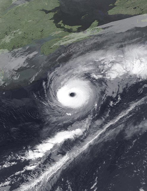
Alex 2004. Yeah that's a giant eye and CDO, "annular"