

Torch Tiger
-
Posts
13,328 -
Joined
-
Last visited
Content Type
Profiles
Blogs
Forums
American Weather
Media Demo
Store
Gallery
Posts posted by Torch Tiger
-
-
Floyd 20 year anniversary
")
-
Just now, 78Blizzard said:
The 12z hurricane models, HWRF and HMON, have definitely trended back to the west and south. And the interim 6z run of the Euro has also. In fact the HMON now has a landfall just north of FL in Brunswick, GA and hugging the coast right up to Savannah. Be interesting to see the 12z Euro.
"Trend" is not necessarily true, though.
-
2 minutes ago, RT1980 said:
I can understand that but I thought this was a majority novice board where people were trying to learn about a hobby. I get the wishcasting/trolling has no place but I don’t see too much in these times of people in the know teaching. Just calling others out for not being in the know or others who have knowledge who happen to disagree out. Oh the interwebs!
It's the same as most other msg boards and social media. The main thread: it's always a few enlightening posts surrounded by 95% filler, you just have to take away what you like to and sift through the rest.
-
 3
3
-
-
9 minutes ago, RT1980 said:
Just seems some can say whatever they want and others disagree and posts vanish! Maybe I don’t know background?
It's always been that way, a lot of groupthink and pig-piling on unpopular opinions and a few over-sensitive types to boot
-
5 minutes ago, OSUmetstud said:
Where is the post?
I forget and too many pages to sift through. We'll see what happens.
-
Could it make LF ? Sure, it's razor close. Most likely outcome? Nah
-
3 hours ago, moneypitmike said:
What a hoot if this went from being a likely FL landfall to Newfoundland one instead. Just a minor miss.
")
Depends who you asked. I was laughed at in the main thread with scrape/ OTS call on Thursday. ;(
-
looks like a Andrew/Katrina/Hugo/Sandy/1944/Floyd/Irma/1893 redux
-
1
-
-
12 minutes ago, Rjay said:
Help make it better
I already did..deaf ears
-
1 minute ago, the ghost of leroy said:
The euro was the opening all the east coast weenies needed to wishcast it into hatteras, Long Island, sne, and coastal Canada.
Right
4 minutes ago, LithiaWx said:Freeport is a poor city on a tiny island. Nothing really tall to destroy. I’ve ridden around the island a few times on scooters.
we need to build asap
-
The model hugging in the main thread is atrocious.
-
Lord, that main thread is horrible.
-
14 hours ago, Indystorm said:
My concern is that Florida is a long state.
Deep stuff
-
25 minutes ago, Benadrill said:
Go out and stand in it then, really close to the coast.
etc
-
cat3+ landfalls for MIA/FLL and TPA would be awesome
-
Y'all crazee
-
Very complex forecast, wow.
-
4 minutes ago, Modfan said:
Hope your right; I sit 45 miles south of Vero Beach and stress level about a 100!
Get after it...time to get excited for awesome
-
59 minutes ago, Cyclone-68 said:
I guess we have our new headlining news story for the holiday weekend in any case
This is going to be awesome, hopefully it stalls right over Orlando for a few days
-
Yorian
Fixes from the reconnaissance plane indicate that Dorian has been
moving toward the northwest or 315 degrees at 11 kt. The cyclone is
heading toward a weakness in the Atlantic subtropical ridge, and
this motion should continue for the next 2 to 3 days. However, after
that time, all global models build a robust ridge over the western
Atlantic, and this flow pattern should force Dorian to turn more
to the west-northwest toward Florida and the southeast coast of the
United States. All indications are that by this Labor Day weekend, a
powerful hurricane will be near the Florida or southeastern coast of
the United States. The new NHC track forecast is not significantly
different from the previous one, and it very closely follows the
multi-model consensus TVCA and the HCCA. Users are reminded not to
focus on the exact forecast track, as the average 5-day track error
is around 200 miles.
-
I like this video..60 years ago and it rings very true today
-
1
-
-
40 minutes ago, STILL N OF PIKE said:
I may Chase Dorian if it goes Cat 2 +
300$ round trip to FL
Cat. 2+ milf?
-
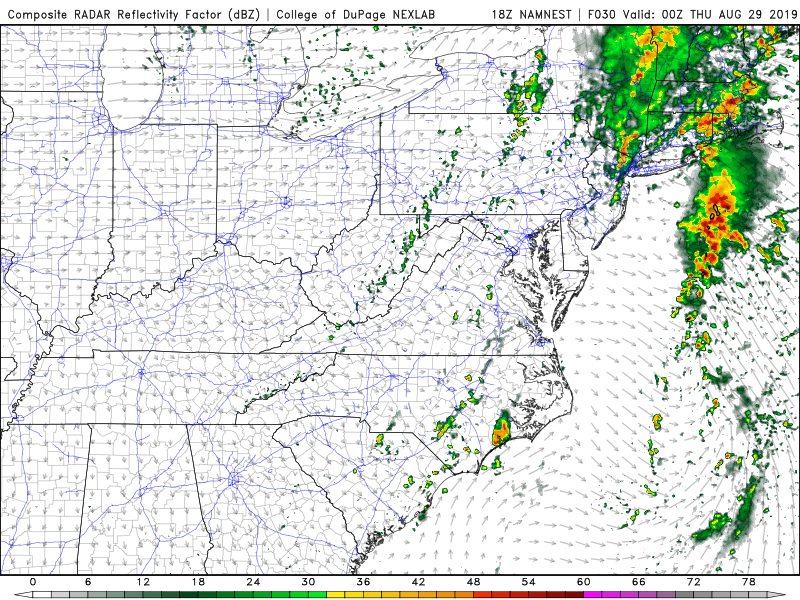
2 hours ago, Vice-Regent said:
Give it some time. Here is the high-resolution output for the PRE (Predecessor Rainfall Event) from 18z NAMNEST.
Edit: JMA is a double SNE-special from TD6 and Dorian.
Intensity busts as well as near stationary cyclones, etc. other factors still display the weaknesses of today's models.
Watching this weak TD curve 350mi. SE of Nantucket is boring, though
-
TD6 is a mess
SNE "Tropical" Season Discussion 2019
in New England
Posted
What happened was on Wednesday, I made a post saying the best track was a scraper and OTS around 4pm, while pretty much every model was west into Florida bodily, and even the gulf including EC ensemble. The weenie mods didn't like my negativity and deleted the post ( but funny they allowed the cat5 into Miami/Panhandle/MS/AL/LA weenie posts to stay)
You can see the banter thread where they called me cheetah and said cheetah/jonger cage match