
.png.6639f727b8f19116077819776032602b.png)
Torch Tiger
-
Posts
12,263 -
Joined
-
Last visited
Content Type
Profiles
Blogs
Forums
American Weather
Media Demo
Store
Gallery
Everything posted by Torch Tiger
-
<3

-
congrats
-
.thumb.png.e1f898d009b2415a204433df288e6f2a.png) I missed the ENH upgrade.. guess that was predictable with 70F dews, strong forcing and high shear. If there's a little more Cape realized, look out ...Portions of the PA/NY vicinity southward/southwestward to the southern Appalachians... A zone of showers and thunderstorms should be ongoing at the start of the period from the mid Ohio Valley/Mid South region south-southwestward to the western Gulf of Mexico, in the vicinity of an advancing surface cold front. A secondary area of showers -- perhaps with some embedded lightning -- will be shifting quickly northeastward across the Carolinas/Virginia vicinity. Only minimal severe risk -- mainly in the form of gusty winds or a brief tornado -- is apparent at this time within either of these areas of convection through the first several hours of the period. With time, the advance of the cold front across the southern, and then the central, Appalachians during the afternoon in conjunction with the strengthening upper system will result in gradual organization of a band of frontal convection. Very strong flow aloft will aid in the convective organization, with upscale evolution toward a semi-continuous band of storms expected. By late afternoon/early evening, storms will likely have become fairly well-organized, crossing south-central and southeastern PA, MD, VA, and the Carolinas along with attendant risk for strong/damaging wind gusts. Low-level wind profiles will become supportive of supercells during the afternoon across the pre-frontal warm sector. While suggestive of some tornado potential, pre-frontal warm-sector storms are largely not anticipated. Still, a few mainly QLCS-type tornadoes will be possible, given the overall dynamic/kinematic set-up -- particularly from late afternoon through mid evening. As storms near the coast overnight, gradual weakening of the convection -- and associated diminishing of the severe risk -- is expected, though limited wind risk will likely extend to near the mid Atlantic/Carolina coasts overnight.
I missed the ENH upgrade.. guess that was predictable with 70F dews, strong forcing and high shear. If there's a little more Cape realized, look out ...Portions of the PA/NY vicinity southward/southwestward to the southern Appalachians... A zone of showers and thunderstorms should be ongoing at the start of the period from the mid Ohio Valley/Mid South region south-southwestward to the western Gulf of Mexico, in the vicinity of an advancing surface cold front. A secondary area of showers -- perhaps with some embedded lightning -- will be shifting quickly northeastward across the Carolinas/Virginia vicinity. Only minimal severe risk -- mainly in the form of gusty winds or a brief tornado -- is apparent at this time within either of these areas of convection through the first several hours of the period. With time, the advance of the cold front across the southern, and then the central, Appalachians during the afternoon in conjunction with the strengthening upper system will result in gradual organization of a band of frontal convection. Very strong flow aloft will aid in the convective organization, with upscale evolution toward a semi-continuous band of storms expected. By late afternoon/early evening, storms will likely have become fairly well-organized, crossing south-central and southeastern PA, MD, VA, and the Carolinas along with attendant risk for strong/damaging wind gusts. Low-level wind profiles will become supportive of supercells during the afternoon across the pre-frontal warm sector. While suggestive of some tornado potential, pre-frontal warm-sector storms are largely not anticipated. Still, a few mainly QLCS-type tornadoes will be possible, given the overall dynamic/kinematic set-up -- particularly from late afternoon through mid evening. As storms near the coast overnight, gradual weakening of the convection -- and associated diminishing of the severe risk -- is expected, though limited wind risk will likely extend to near the mid Atlantic/Carolina coasts overnight. -
Too bad it fades coming NE..a little svr threat for the MA anyway
-
winter in winter, please
-
I forgot how late it was, it seemed to be just before sunset in SE MA. I think what helped at the time was the sun was setting, not sure it would have snowed a few hours earlier.
-
want The biggest question mark is on how much of the winds mix to the surface. Strong low-level warm advection in the lowest part of the column may keep stability profiles closer to weakly stable until we get on the backside of the cold front; that stability profile could in turn result in less of a percentage of this strong jet to translate to surface gusts. Felt the most confident on winds capable of producing damage across the Cape and the Islands, into the southern coast of MA and towards Block Island and Newport Counties. Even if 60 percent of the flow mixed to the ground, that still gets you at least into Advisory criteria, with potential for stronger. What may also transpire is strong/damaging winds could accompany the front itself embedded in the dynamic/strong cold frontal heavy showers (accompanied by elevated instability/thunder). Do feel potential exists for 40 to 60 mph gusts in the Watch area, especially in the pre-dawn to early-mid Friday morning period. So this may be a little bit different than prior strong wind events experienced in October. Given the potential and the model signals/consistency, think it was worth raising awareness with the Watch at this point in time.
-
Iirc it snowed at 40-45F in Attleboro...like Will said, started as graupel and eventually cooled enough to flip
-
Was the snow in the afternoon/evening? Pretty sure I recall the same.
-
Cold right where we want it.
-
Mid-Atlantic winter 2019-20 snowfall contest
Torch Tiger replied to PrinceFrederickWx's topic in Mid Atlantic
BWI 7.1" DCA 2.4" IAD 8.2" RIC 1.5" SBY 4" -
The 31 mph gusts and rain showers would be too much struggle street for the kiddos
-
Every one of us has something taken down, big fall cleanup incoming this weekend.
-
May 18th 2002 was pretty good. Had like 4" iirc sadly no older folks mentioned the desert dry of '65
-
many areas didn't top 40mph in that last one...should be doable
-
This will definitely surpass the last event for many.
-
That is a cutter
.thumb.png.cad13521175e3a17bd5ada98abcc8d0a.png)
-
Not bad. 71/65 ktan?
-
This is going to be a sneaky big event imo.
-
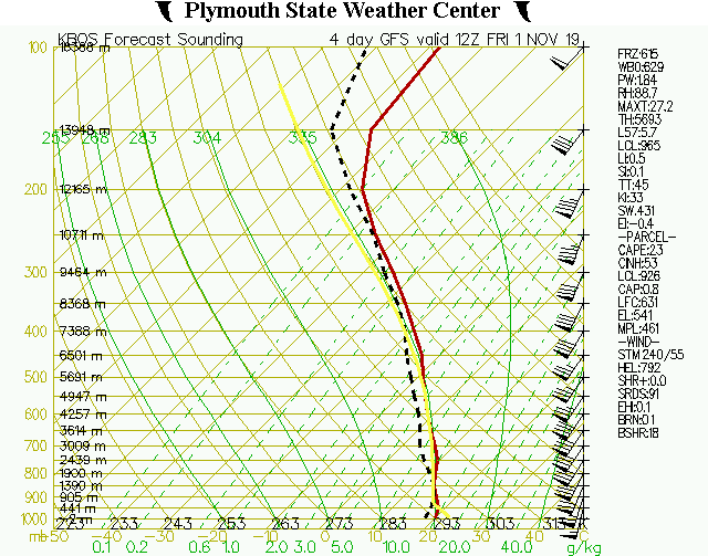
Hopefully the finest line ever Thursday night into Friday... Deepening mid level low lifts NE across the Gt Lakes and into Canada. Main surface low will be tracking well to the north with attending cold sweeping across SNE late Thu night into early Fri. Robust low level jet increasing and peaking around 70+ kts as it crosses NE New Eng late Thu night/early Fri. Wind and PWAT anomalies 4-5SD above normal which is a strong signal for a period of heavy rainfall and strong wind gusts. Some elevated instability exists so potential for a fine line of convection along the front as it sweeps through. Further details will become available on Wed as event is captured within the time range of the hi-res CAMs. Temps will be quite mild Thu night ahead of the front with readings well into the 60s and may top out around 70 in eastern New Eng. This will help to enhance low level mixing with potential for strong to damaging wind gusts in eastern New Eng which would be enhanced if any convective fine line develops. Wind headlines may be needed.
-
banger
-
Nice week upcoming. No real bn temps, wind event early Friday, everything is awesome
-
Hope so
-
GYX may be bringing 'em up by Friday The boundary may stall across the Gulf of Maine or just shy of it as a negatively tilting upper low moves out of the Midwest and quickly swings northeast just north of the international border by Friday morning. This will set us up for an intense synoptic-scale forcing event which hopefully arrives overnight after the trick-or-treating ends. Confidence in this scenario is moderate and increasing as long term models continue to agree on certain details. Friday will be a soaking for everyone as the system lifts across the area. High PWATs, deep warm cloud depths, and a drawn out rain event all point toward some river flooding concerns. Ensemble forecasts are indicating that several rivers may reach action stage.
-
Hopefully it really ramps up into one of those real special events with a fine line 50-70mph regionwide


.png.ffd55e352d1451cb3de5b5c47604d29c.png)
