

Ruin
-
Posts
1,519 -
Joined
-
Last visited
Content Type
Profiles
Blogs
Forums
American Weather
Media Demo
Store
Gallery
Everything posted by Ruin
-
Central PA Winter 25/26 Discussion and Obs
Ruin replied to MAG5035's topic in Upstate New York/Pennsylvania
Because from the start, no one has actually given an actual reason why the models suck so badly. They give excuses.They say it's not as bad as you think.It is, or they just don't respond to the question.That's why I complain.We're in twenty twenty six.We think a model or a forecast should be accurate at least 223 days out but it isn't -
Central PA Winter 25/26 Discussion and Obs
Ruin replied to MAG5035's topic in Upstate New York/Pennsylvania
That's my a complaint yet I get bashed over such things. People never really answer me.They just kind of shove it off to the side, and just say i'm complaining -
Central PA Winter 25/26 Discussion and Obs
Ruin replied to MAG5035's topic in Upstate New York/Pennsylvania
saw the forecast on my app little to no accumulation tho most fav words of weather around here for forecasts. why bother with a weather alert if the write up is a copy and paste of that -
yeah we wont even get 5% of that lol
-
Central PA Winter 25/26 Discussion and Obs
Ruin replied to MAG5035's topic in Upstate New York/Pennsylvania
What gets me forecast low last night 28. It went all the way too 22 today's high 45 got to 49 here. How do you go lower over night then projected but then recover and beat the forecasted high ? -
Central PA Winter 25/26 Discussion and Obs
Ruin replied to MAG5035's topic in Upstate New York/Pennsylvania
lol a far cry for what models show 1 day ago -
lol whole bunch of nodda
-
why I dont trust models not even 1-2 days out they change way to much for the same model from 1 run to the next
-
Central PA Winter 25/26 Discussion and Obs
Ruin replied to MAG5035's topic in Upstate New York/Pennsylvania
the 26th? lol um yeah book mark this watch it be like 50 and sunny lol. -
most likely will be colder with the storm bringing down cold air north west.
-
How does this model have rain north west of the snow lol
-
Central PA Winter 25/26 Discussion and Obs
Ruin replied to MAG5035's topic in Upstate New York/Pennsylvania
nope -
Central PA Winter 25/26 Discussion and Obs
Ruin replied to MAG5035's topic in Upstate New York/Pennsylvania
nothing happenend with it even tho I was under it for 4 hours temps went from 19 too 24 still cloudy -
Central PA Winter 25/26 Discussion and Obs
Ruin replied to MAG5035's topic in Upstate New York/Pennsylvania
U wouldnt surprise me if they're just trying to push a temp up a little bit.So that they're right with their forecast -
Central PA Winter 25/26 Discussion and Obs
Ruin replied to MAG5035's topic in Upstate New York/Pennsylvania
any reports of this hitting the ground? observations on weather sites just go by radar now not any human and makes observations. Not doing anything atm but radar shows this.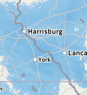
-
models that do temp guidance have been so wrong over the last 7 winters always show this historic cold for weeks turns out to be a bit below for a day or 2
-
Central PA Winter 25/26 Discussion and Obs
Ruin replied to MAG5035's topic in Upstate New York/Pennsylvania
im so so so so tired of models showing cold the forecast shows cold then models flip and then the forecast goes from upper 20s to low 30s now shows mid 40s? this is from the 6th on. Now they are forecasting a mini warm up just form this signal just yesterday it was showing cold I looked out a week ahead cause half my job is outside. It just amazes me so now we are kicking the can down the road again for any chance of snow -
-
Central PA Winter 25/26 Discussion and Obs
Ruin replied to MAG5035's topic in Upstate New York/Pennsylvania
Many many mets have a warm bias -
Central PA Winter 25/26 Discussion and Obs
Ruin replied to MAG5035's topic in Upstate New York/Pennsylvania
This is my problem they change a forecast 30 times before the day happens and say they are accurate. -
Central PA Winter 25/26 Discussion and Obs
Ruin replied to MAG5035's topic in Upstate New York/Pennsylvania
And yeah, pretty sure that this wind was supposed to subside early today.But it didn't -
Central PA Winter 25/26 Discussion and Obs
Ruin replied to MAG5035's topic in Upstate New York/Pennsylvania
Lol same story every winter -
Yep, I get so tired of people saying, oh, the cold is a week away.The cold is a week away, and then it gets pushed back.And pushed back, and then when we actually do get into the cold..Nowhere near is.It has historic as the temperature guidance suggested instead of like being thirty degrees below.Average.It's like ten
-
Central PA Winter 25/26 Discussion and Obs
Ruin replied to MAG5035's topic in Upstate New York/Pennsylvania
Live right outside harrisburg -
Central PA Winter 25/26 Discussion and Obs
Ruin replied to MAG5035's topic in Upstate New York/Pennsylvania
Temp 33.2


