

tiger_deF
-
Posts
543 -
Joined
-
Last visited
Content Type
Profiles
Blogs
Forums
American Weather
Media Demo
Store
Gallery
Everything posted by tiger_deF
-
Been there since that ICON run yesterday my friend
-
Again as with the EPS, like 10-20% of those runs would be absolutely disastrous assuming Teddy becomes as strong as forecasted, along with the baroclinic forcing as it starts to transition
-
This is setting up to be either a huge disappointment (or relief depending on the poster) or potentially a high impact event
-
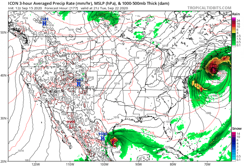
Big weenie setup on the ICON, let's see if it holds the next few days
-
Another day, another SW shift on the GFS
-
Yeah, the pattern that would produce a serious storm up here is like a meteorological needle in a haystack. That being said, there is definitely potential for conditions that would be conducive to a pull west provided everything comes together, and I think that we should be tracking this until the models (especially the EPS) move back east. In addition, Teddy is forecasted to be an enormous and powerful storm, especially once it interacts with the trough, so if for some ungodly reason a NE situation did verify, it would likely be serious.
-
This season feels similar to 2004 in terms of impacts, however instead of tracking powerful, longtracking canes that usually made landfall past their peak, we've been tracking areas of vorticity and elongated waves that suddenly decide to get their act together within days of landfall
-
Euro with the left hook, where have we seen that before Still looking to be OTS but I would say chances of some kind of impact have risen somewhat
-
Major shift west for the GFS
-
They'd be right unfortunately Unrelated, I think totally writing off any threat is just as irresponsible as doomcasting, we are 172 hours out and things can easily change.
-
Decent shift west on the GFS, sets up a similar high/trof system to the ICON, but the angle of the trough is significantly steeper and fails to capture the system. Still barely scrapes over Nova Scotia.
-
Just remember, all these threats never materialize or verify... until they do. All it takes is one
-
More important is the trend that models are no longer ratcheting this to the right, but are keeping it's north heading, or even turning slightly west
-
Of course I don't expect this to happen, but I do feel like some sort of impact from Teddy is definitely not entirely out of the cards. Just hypothetically, this situation would easily push 15-20 feet of surge right into the bay. Can't even imagine the level of devastation
-
Oh my
-
Y'all are spoiled
-
For what it's worth the GEFS has a significant westward shift, with easily 20% of the models raking/making landfall in SNE
-
I have a feeling 20L (soon to be teddy) might be a sleeper threat, the track and models have been shifting west and the general (west then a turn directly north) is certainly conductive for NE impacts
-
Just pointing out that Laura was significantly stronger upon CONUS landfall than every single one of 2005's US threats
-
Just wait until we get an actual below average season, I think the season cancel folks might go nuts
-
Pretty consistent signal for something in the area on the GFS
-
Models have been shite with genesis all season... I've never seen them so suppressed. You'd think we haven't had a 14-4-1 by August 27th
-
This may age badly
-
Was raining and windy in Boston earlier but very still now Edit- the rain has now picked up substantially and so has the wind
-
Microburst touched down a mile away near my former elementary school and took down a few trees


