Moosey2323
-
Posts
88 -
Joined
-
Last visited
Content Type
Profiles
Blogs
Forums
American Weather
Media Demo
Store
Gallery
Everything posted by Moosey2323
-
Mid-week potential of something somewhere
Moosey2323 replied to Chicago Storm's topic in Lakes/Ohio Valley
Anyone have a zoomed-out map for the Michigan folks? -
Mid-week potential of something somewhere
Moosey2323 replied to Chicago Storm's topic in Lakes/Ohio Valley
DTX AFD -
Mid-week potential of something somewhere
Moosey2323 replied to Chicago Storm's topic in Lakes/Ohio Valley
It's not uncommon for watches to turn into advisories -
Mid-week potential of something somewhere
Moosey2323 replied to Chicago Storm's topic in Lakes/Ohio Valley
Congrats to Chicago. Detroit not looking so great. -
NAM with a kill shot for Southeast Michigan. I don't want to get my hopes up but...
-
January 10th-12th Winter Storm Potential
Moosey2323 replied to Thundersnow12's topic in Lakes/Ohio Valley
I think the general rule of thumb is to underestimate the northward extent of the warm front, especially in situations with convection to the south. The Euro/Canadian seems to place the warm front too far north. I think the NAM 3km is the better solution. -
January 10th-12th Winter Storm Potential
Moosey2323 replied to Thundersnow12's topic in Lakes/Ohio Valley
The Euro is still a lot warmer than the NAM. That warm front placement is still very uncertain and will dictate the precipitation for Michigan especially -
January 10th-12th Winter Storm Potential
Moosey2323 replied to Thundersnow12's topic in Lakes/Ohio Valley
At forecast hour 12, the Euro is already 10 degrees warmer than the NAM 3km -
January 10th-12th Winter Storm Potential
Moosey2323 replied to Thundersnow12's topic in Lakes/Ohio Valley
Not sure if this has been posted yet, but an excellent read from the LOT AFD about the ice numbers shown on model output. -
January 10th-12th Winter Storm Potential
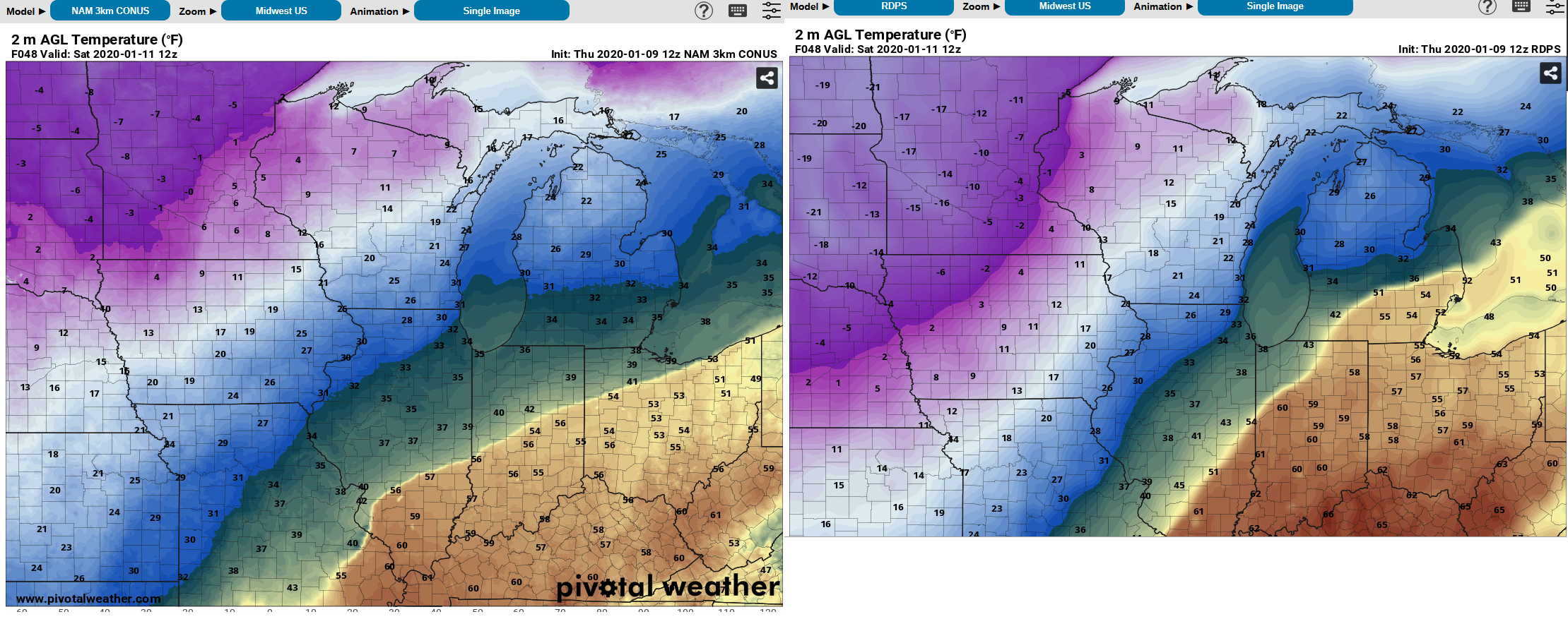
Moosey2323 replied to Thundersnow12's topic in Lakes/Ohio Valley
To illustrate the differences in the warm front placement...Taken at the same time for NAM and RDPS
-
January 10th-12th Winter Storm Potential
Moosey2323 replied to Thundersnow12's topic in Lakes/Ohio Valley
There are still significant differences in terms of the placement of the warm front in Michigan. The NAM and GFS don't have any of the 40s or 50s getting into Michigan before the main precip while the Canadian models show warm temps making it up. This is a major difference because it determines whether the ground will be warm enough to avoid ice accumulation. -
January 10th-12th Winter Storm Potential
Moosey2323 replied to Thundersnow12's topic in Lakes/Ohio Valley
GRR put some watches out -
January 10th-12th Winter Storm Potential
Moosey2323 replied to Thundersnow12's topic in Lakes/Ohio Valley
In terms of headlines, would any watches go out tomorrow? Or Friday? -
January 10th-12th Winter Storm Potential
Moosey2323 replied to Thundersnow12's topic in Lakes/Ohio Valley
Ice is much farther south than the NAM -
January 10th-12th Winter Storm Potential
Moosey2323 replied to Thundersnow12's topic in Lakes/Ohio Valley
Updated WPC forecast for ice meeting warning conditions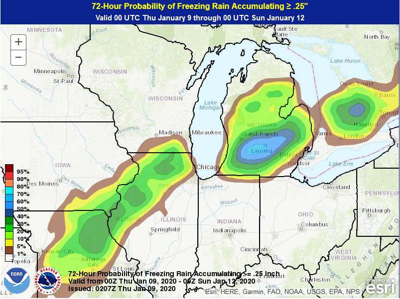
-
January 10th-12th Winter Storm Potential
Moosey2323 replied to Thundersnow12's topic in Lakes/Ohio Valley
The main issue with this freezing rain is going to be anything that is elevated. Trees and powerlines are going to take most of the ice. -
January 10th-12th Winter Storm Potential
Moosey2323 replied to Thundersnow12's topic in Lakes/Ohio Valley
Interesting that the op GFS is the extreme with regards to temperature.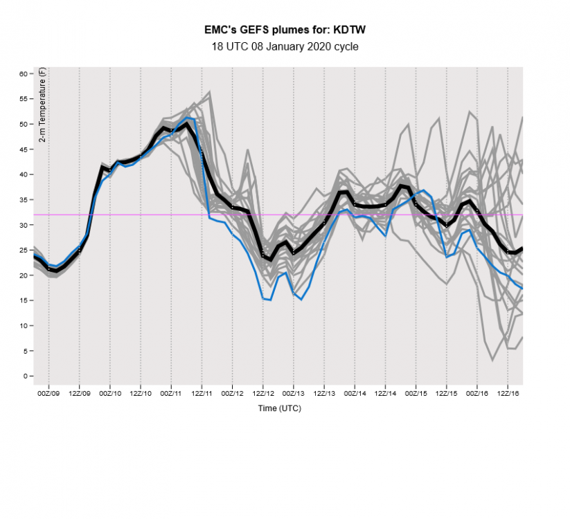
-
January 10th-12th Winter Storm Potential
Moosey2323 replied to Thundersnow12's topic in Lakes/Ohio Valley
Yes, but nothing compared to the numbers on the NAM. Even the LOT AFD acknowledged this was likely erroneous. -
January 10th-12th Winter Storm Potential
Moosey2323 replied to Thundersnow12's topic in Lakes/Ohio Valley
I still think the icing needs to be taken with a grain of salt. The precip rates are going to be quite high. The NAM is definitely overdoing it. -
January 10th-12th Winter Storm Potential
Moosey2323 replied to Thundersnow12's topic in Lakes/Ohio Valley
Canadian has depressed snowfall amounts and also misses Chicago. -
January 10th-12th Winter Storm Potential
Moosey2323 replied to Thundersnow12's topic in Lakes/Ohio Valley
I'm just surprised to see the GFS, Euro, and Canadian showing something similar. It's unusual to see the models jump on the same bandwagon this season. It gives me hope for this one, but I'm also ready to get hurt again. -
January 10th-12th Winter Storm Potential
Moosey2323 replied to Thundersnow12's topic in Lakes/Ohio Valley
The 18z was remarkably similar to the 12z; the line of ice hits the same counties. However, the amounts are slightly depressed. -
Winter 2019-20 Medium/Long Range Discussion
Moosey2323 replied to Hoosier's topic in Lakes/Ohio Valley
Canadian has a similar track but weaker. -
Winter 2019-20 Medium/Long Range Discussion
Moosey2323 replied to Hoosier's topic in Lakes/Ohio Valley
Ice accumulations could be on the lighter side with this storm, especially at the surface. A lot of the areas with freezing rain reach high 40s and even low 50s on Friday afternoon. The wind speeds are also on the slower side. Of course trees and power lines could still be an issue regardless. Just something to keep an eye on. -
DTX AFD