Moosey2323
-
Posts
88 -
Joined
-
Last visited
Content Type
Profiles
Blogs
Forums
American Weather
Media Demo
Store
Gallery
Everything posted by Moosey2323
-
All eyes on this cumulus field -- entering the higher CAPE environment...Cell on the northeast corner seemed to fire off.
- 1,696 replies
-
- 1
-

-
- severe
- thunderstorms
- (and 5 more)
-
2023 Mid-Atlantic Severe Wx Thread (General Discussion)
Moosey2323 replied to Kmlwx's topic in Mid Atlantic
Storm motion is now to the ESE. Line is moving ever so slightly into a better sheared environment -- hence the increasing organization. -
2023 Mid-Atlantic Severe Wx Thread (General Discussion)
Moosey2323 replied to Kmlwx's topic in Mid Atlantic
SPC Mesoanalysis shows > 3500 SBCAPE and > 30 kts of bulk shear. Are we just failing to get a reliable lifting mechanism? That little boundary that passed through seemed to act as one, but the cells still had trouble surviving.- 2,785 replies
-
- 1
-
-
- severe
- thunderstorms
- (and 3 more)
-
2023 Mid-Atlantic Severe Wx Thread (General Discussion)
Moosey2323 replied to Kmlwx's topic in Mid Atlantic
Did these cells form off an outflow boundary? Seeing something like one on Radarscope. -
2023 Mid-Atlantic Severe Wx Thread (General Discussion)
Moosey2323 replied to Kmlwx's topic in Mid Atlantic
I'd argue the lack of upper air divergence is one of the main culprits today. That could've helped initiate many more cells in this thermodynamic environment. Looking at the 300mb analysis on SPC Mesoanalysis...and the locations of those magenta regions are telling. -
2023 Mid-Atlantic Severe Wx Thread (General Discussion)
Moosey2323 replied to Kmlwx's topic in Mid Atlantic
Will this big cirrus shield (that one of the first cells formed) inhibit convection in northern Virginia? -
2023 Mid-Atlantic Severe Wx Thread (General Discussion)
Moosey2323 replied to Kmlwx's topic in Mid Atlantic
71 F on NAM / 61 F on HRRR...that's a pretty large difference. Even if we land somewhere in the middle, that might be enough though. I also wonder if the bust over central Ohio will reduce the amount of cloud cover the region receives tomorrow. -
This storm near Hillsdale....
-
It's been strange from the start...the first Day 3 outlook was general thunder, and they had to the rare reissue to add a marginal area.
-
The wind field is great. Instability could be hit or miss depending on the cloud cover. While some of the hodos look tornado conducive, I think the storm mode will be predominantly linear, limiting any major tornado threat.
-
GRR Discussion:
-
Tuesday Sep 07 has potential. Still some variability between models but my guess is someone in the region will have good shear and cape.
-
Model dewpoints continuing to look worse than yesterday. RAP shows a decent clearing for eastern Michigan by about 14z. If this verifies should be a good wind event.
-
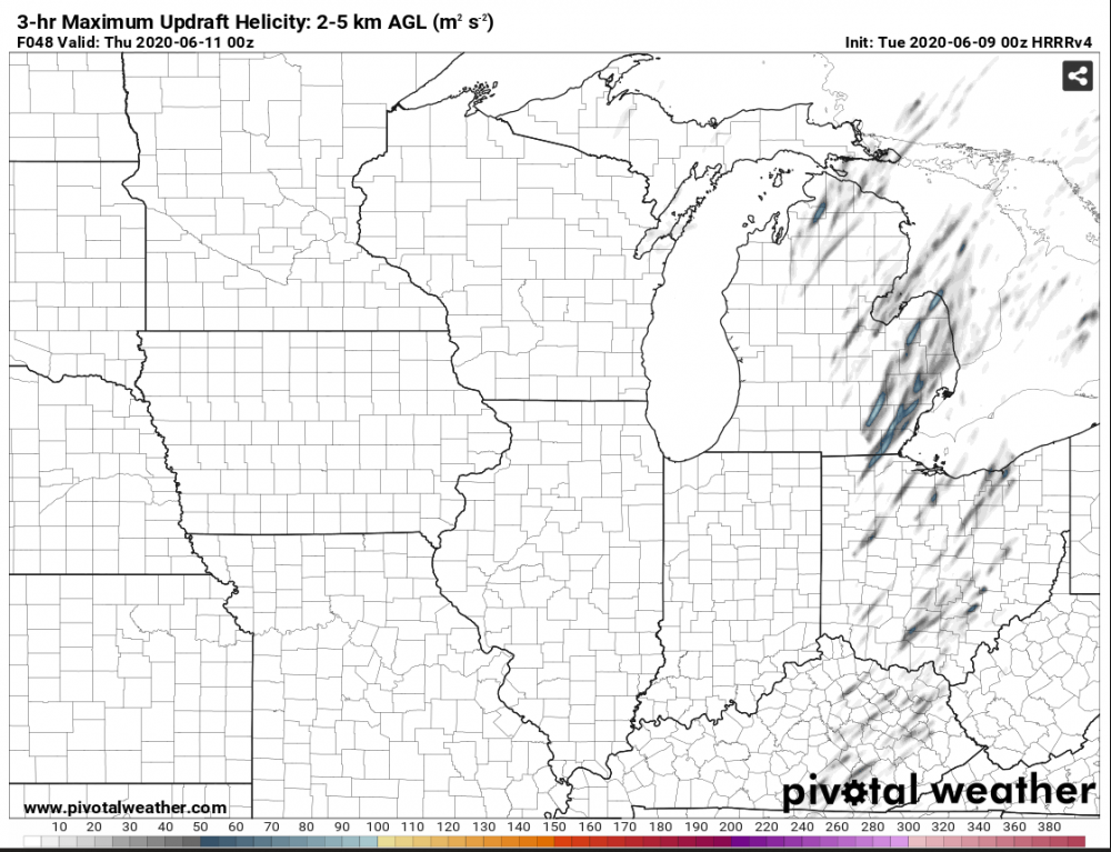
HRRRv4 is a bit weaker on surface dewpoints. NAM3k looks about the same as previous runs. Main question seems to be whether there will be discrete cells ahead of the main line.
-
HRRRv4 shows some cells forming ahead of the line. Will have to keep an eye on those.
-
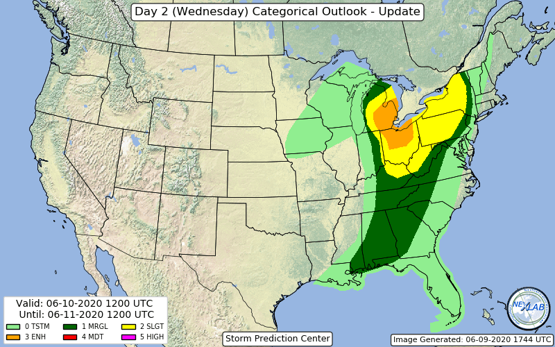
Day 2 upgrade to enhanced.
-
HRRRv4 really slowing down the cold front progression. Wednesday could actually be more active than initially expected for Michigan.
-
Tuesday has my interest. I'm interested to see what the Day 3 outlook looks like tomorrow.
-
May 13-19 Severe/Heavy Rain threats
Moosey2323 replied to Tim from Springfield (IL)'s topic in Lakes/Ohio Valley
Detroit Update to the AFD: -
May 13-19 Severe/Heavy Rain threats
Moosey2323 replied to Tim from Springfield (IL)'s topic in Lakes/Ohio Valley
NAM 3km (18z) shows an interesting feature along the Michigan-Indiana border. Looks like a bowing segment. Will have to keep an eye on that. -
Mid-week potential of something somewhere
Moosey2323 replied to Chicago Storm's topic in Lakes/Ohio Valley
The UK just cancelled the Detroit special
-
Mid-week potential of something somewhere
Moosey2323 replied to Chicago Storm's topic in Lakes/Ohio Valley
Canadian
-
Mid-week potential of something somewhere
Moosey2323 replied to Chicago Storm's topic in Lakes/Ohio Valley
GFS not a good look. I'm interested to see what the GEFS members do. -
Mid-week potential of something somewhere
Moosey2323 replied to Chicago Storm's topic in Lakes/Ohio Valley
GEFS members coming in with the Detroit special -
Mid-week potential of something somewhere
Moosey2323 replied to Chicago Storm's topic in Lakes/Ohio Valley
GEFS looks a lot weaker