Sernest14
-
Posts
423 -
Joined
-
Last visited
Content Type
Profiles
Blogs
Forums
American Weather
Media Demo
Store
Gallery
Everything posted by Sernest14
-
Richmond Metro/Hampton Roads Area Discussion
Sernest14 replied to RIC Airport's topic in Mid Atlantic
9” drifts? Looked about 3” or so on the last page -
Richmond Metro/Hampton Roads Area Discussion
Sernest14 replied to RIC Airport's topic in Mid Atlantic
Now all we need is the low to hug the coast for a while and stall -
Richmond Metro/Hampton Roads Area Discussion
Sernest14 replied to RIC Airport's topic in Mid Atlantic
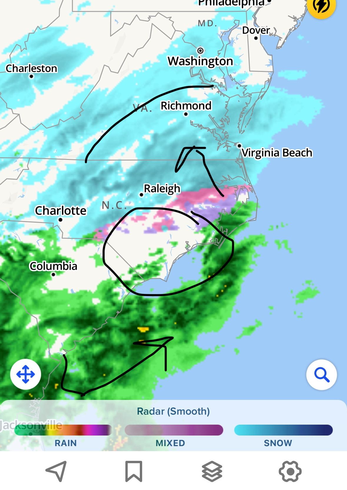
It’s already depicting that on the radar loops, just need to allow the low to keep working its way up -
Richmond Metro/Hampton Roads Area Discussion
Sernest14 replied to RIC Airport's topic in Mid Atlantic
per 12z nam, we were only at .01-05” through 1 pm Hrrr .01-.05” through 2pm As the low creeps up it’s going to fill in more and also push the better returns into our area which is what almost all the models show as well
-
Richmond Metro/Hampton Roads Area Discussion
Sernest14 replied to RIC Airport's topic in Mid Atlantic
its building back in per radar. West is going to continue to show dry due to mountains in western Carolina but will build back in as it crosses into va -
Richmond Metro/Hampton Roads Area Discussion
Sernest14 replied to RIC Airport's topic in Mid Atlantic
Radar depiction down in the south at the gulf looks much more amplified (assuming a stronger low). Hopefully can power through more than what the models show to give us a little shift nw. also looked a couple hours early and is heavier in western/central tn -
Richmond Metro/Hampton Roads Area Discussion
Sernest14 replied to RIC Airport's topic in Mid Atlantic
Assuming they are running with 15:1. Most qpf is around .4-.5 which puts it in the range then the trickle nw that tends to happen as well -
Richmond Metro/Hampton Roads Area Discussion
Sernest14 replied to RIC Airport's topic in Mid Atlantic
Such a lazy forecast- they always do that -
Richmond Metro/Hampton Roads Area Discussion
Sernest14 replied to RIC Airport's topic in Mid Atlantic
any reasoning behind this for the NAM or is it just weakening and dying over the mountains?
-
Richmond Metro/Hampton Roads Area Discussion
Sernest14 replied to RIC Airport's topic in Mid Atlantic
Definitely curious to see what NAM does at 00z, 6/18 have been drier than 00/12 over - also feel like I’ve heard there’s not as much data to work with during 6/18 so not as accurate? No idea how true that is -
Richmond Metro/Hampton Roads Area Discussion
Sernest14 replied to RIC Airport's topic in Mid Atlantic
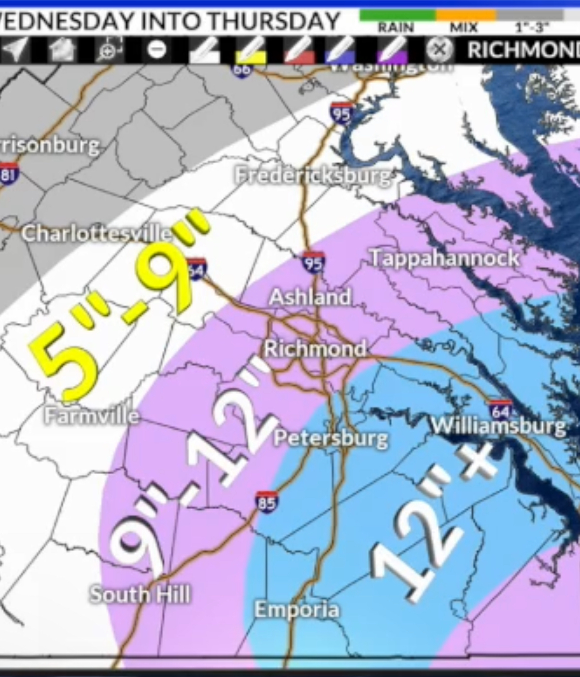
Dinardo’s updated map
-
Richmond Metro/Hampton Roads Area Discussion
Sernest14 replied to RIC Airport's topic in Mid Atlantic
anywhere have the graf free? -
Richmond Metro/Hampton Roads Area Discussion
Sernest14 replied to RIC Airport's topic in Mid Atlantic
12k has a lot more sleet -
Richmond Metro/Hampton Roads Area Discussion
Sernest14 replied to RIC Airport's topic in Mid Atlantic
Its been pretty good in this area all winter -
Richmond Metro/Hampton Roads Area Discussion
Sernest14 replied to RIC Airport's topic in Mid Atlantic
12k NAM looks more robust and better than 6z -
Richmond Metro/Hampton Roads Area Discussion
Sernest14 replied to RIC Airport's topic in Mid Atlantic
NAM looking slightly better through 26 -
Richmond Metro/Hampton Roads Area Discussion
Sernest14 replied to RIC Airport's topic in Mid Atlantic
Definitely more south and colder -
Richmond Metro/Hampton Roads Area Discussion
Sernest14 replied to RIC Airport's topic in Mid Atlantic
It really didn’t perform bad at all and was actually more accurate than the euro if you look at the ensembles -
Richmond Metro/Hampton Roads Area Discussion
Sernest14 replied to RIC Airport's topic in Mid Atlantic
Actually may have just flipped to rain -
Richmond Metro/Hampton Roads Area Discussion
Sernest14 replied to RIC Airport's topic in Mid Atlantic
HRRR and Nam both show freezing precip through 6am -
Ended with 6” with a lot of sleet in between (Ashland). Still heavy sleet and am sure that will continue to compress things a bit. should be frozen still for next few hours though
-
Richmond Metro/Hampton Roads Area Discussion
Sernest14 replied to RIC Airport's topic in Mid Atlantic
Ended with 6” with a lot of sleet in between. Still heavy sleet and am sure that will continue to compress things a bit -
Richmond Metro/Hampton Roads Area Discussion
Sernest14 replied to RIC Airport's topic in Mid Atlantic
Nice little spurt coming up in the next 10-15 -
Richmond Metro/Hampton Roads Area Discussion
Sernest14 replied to RIC Airport's topic in Mid Atlantic
Heaviest snow so far- at ~5” -
Richmond Metro/Hampton Roads Area Discussion
Sernest14 replied to RIC Airport's topic in Mid Atlantic
Heaviest snow so far- at ~5.5”