

clskinsfan
-
Posts
10,002 -
Joined
-
Last visited
Content Type
Profiles
Blogs
Forums
American Weather
Media Demo
Store
Gallery
Everything posted by clskinsfan
-
GFS and Euro are pretty damn close to each other at a 9 day lead. Details to be worked out obviously.
-
18Z GFS looks decent for some falling mashed potatoes out here. Bring it.
-
RGEM pretty similar to the Euro. PSU land would probably see a dusting at least. Maybe a snow shower out this way from a streamer or two. Somebody up in northern MD should probably start a thread. We are 2 days out from our first chance at some flakes.
-
I am feeling pretty confident that a lot of us will see our first flakes later this week. One storm at a time for me going forward.
-
Not having my first flakes out here by Nov 15th usually means a back loaded winter. Clearly nothing scientific about it. But it is rare to not have some flakes by that date here.
-
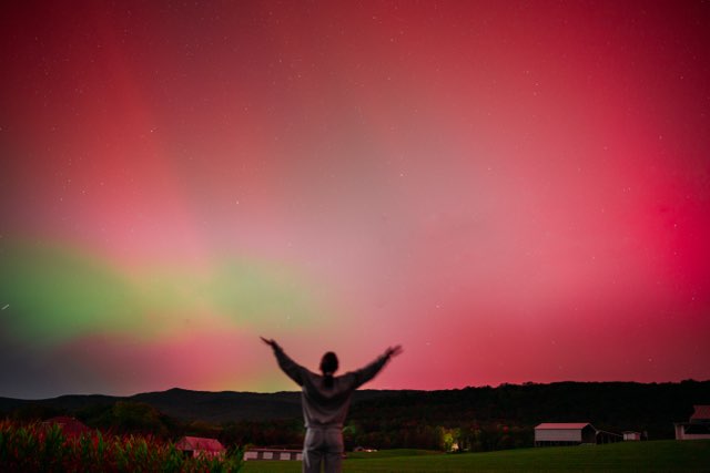
This was out here in the mountains. It was bright enough that the houses in the foreground appeared pink. Most amazing aurora I have ever seen.
-
We are way behind schedule out here in the mountains. My fire bushes are all over half green still. Should be brightly red at this point.
-
I am wondering how much the whacky sst's are effecting the NAO? The Mid Atlantic has had a persistent cold pool with areas to the north warmer than normal. I am of the opinion that is effecting our normal winter baroclinic zone at least. And hence storm tracks.
-
You should have chased the ENFORSEEN tornado outbreak in Florida. A ton of sarcasm here.
-
This tornado outbreak in southern Florida is insane right now. 10 active conformed tornadoes on the ground as I am typing this.
-
Back to a cat 5. Unreal.
-
Isla Perez looks like it will take a direct hit. Could completely erase those small islands.
-
One of the most perfect radar/satellite presentations I have ever seen in the GOM. What a beast.
-
First digital blues for the mountains as well. Winter is coming.
-
Yeah. You are right 26 is still open I guess.
-
Asheville, NC is completely cut off by land. Only air resources are capable of reaching a city of roughly 100000 people. All of the bridges and roads into the city are destroyed. This is a catastrophe of epic proportions.
-
View from the roof of Unicoi County Hospital. https://x.com/smokiesvol/status/1839728726067544246
-
Flooding in Atlanta https://x.com/GAFollowers/status/1839691997776351407
-
https://x.com/WestminsterWCAT/status/1839694563352490215
-
https://x.com/NCDOT_Asheville/status/1839672315254059441
-
Apparently being a Christian here is not accepted anymore. And I am fine with it. Be back in the winter. God Bless!
-
Hugo was a baby compared to this. Tiny little bitch
-
Holy shit. What a fucking monster. Whatch the towers fire off
-
What the actual fuck are you taking about?
-
None


