clskinsfan
-
Posts
10,002 -
Joined
-
Last visited
Content Type
Profiles
Blogs
Forums
American Weather
Media Demo
Store
Gallery
Everything posted by clskinsfan
-

-
RGEM has the low crossing over eastern NC to right over OC. Icy for the cities. It then dumps 30+ inches on NYC.
-
No. 43. Good catch.
-
RGEM is a no.
-
-
Weaker HP on the NAM. Struggled with the CAD. But the NAM struggles with everything.
-
NAM looks good for an inch or two tomorrow.
-
Thanks for this,. That site is awesome.
-
agree. I want the cloud cover to come in while we are close to freezing.
-
-
36/32 The earlier we can get the precip in the better. NWS going with a high of 40 tomorrow.
-
https://nyskiblog.com/directory/weather-data/northeast-us/40-70-benchmark-map/
-
@WinterWxLuvr Here is the link to that thread in the NYC forum. The 3 hour pressure change map is in there I think. Also for everyone else this is a good thread to bookmark for storms: Actually. Disregard this. It appears most of the maps are no longer active in this thread.
-
 I dont want to hijack your thread but do one of you have a bookmark saved for the storm map thread you used to have here? I want to bookmark it to my new computer. Thanks! NVM all. I found it. I hope you all get crushed up here!
 -
I dont know man. The models are saying 1.5 to 2.25 QPF with this one. That is enough for 20 inches with the right ratios.
-
Yes. 09 was definitely colder. But it appears this one is going to have plenty of juice to work with.
-
Much smaller.:)
-
Funny thing is the setup has screamed 20 incher for us for days. I mean the models locked onto a pattern that is just perfect our area. We may not hit 20 but we are gonna get hammered.
-
One of the maps in that NY City maps thread has it. I cant seem to find that thread though.
-
wrong thread
-
Still flurries Thursday morning. What a run.
-
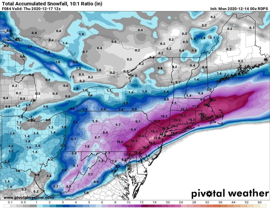
75 the 81 Corridor is smoked. 84. Holy crap. What a beatdown for the western crew.
-
At 63 the 850 line is down at the NC VA border. Looks good so far.
-
CAD showing up nicely at 48.
-
https://meteor.geol.iastate.edu/~ckarsten/cobb/cobb.php?model=namm&site=kmrb