
Hazey
-
Posts
2,705 -
Joined
Content Type
Profiles
Blogs
Forums
American Weather
Media Demo
Store
Gallery
Posts posted by Hazey
-
-
I would ignore that euro run. Must have had a bad burrito or something. No way it's wide right with every other model amped up. Just the euro doing it's usual 3-5 day forecast period tour around the map before it comes back.
-
 2
2
-
-
1 minute ago, cleetussnow said:
I think the 16th storm is going to be wobbly until after the cutter this weekend.
Agreed. Need to get that out of the way then we'll see where we stand.
-
5
-
-
The day 4- 7 model period is getting annoying. I feel lately that that is the time frame when s/w's make big jumps around. Ensembles until day 3 at the earliest. Hopefully has a clue by day 2 but not always. Anyway good period coming up next week. Hopefully someone cashes in.
-
2
-
-
That euro run crushes me. Fits the double cutter pattern reset nicely. Watching closely.
-
1
-
-
That's pretty darn cold at the end of the euro.
-
We need these two cutters to reset things, then its' go time. Sucks but a week will be here and gone in short order. Just hope there is minimal damage in between.
-
Looks like two cutters in the period then pattern resets and we have chances again. Fingers crossed
-
2
-
-
Those two cutters/screamers are gonna hurt. What a shame can't even get cold and dry to enjoy the winter landscape. Ohwell.
-
Congrats guys. Nice way to get back in the game with a big play. Just 2” in my hood. Wasn’t expecting much but looks great. We winter….for a few days.
-
1
-
-
Cutters of yore are nothing like the cutters now. These cutters today are more like mini TC's. High dews, High PWAT's, High winds, high temps. Season destroyers or close to it.
-
2
-
 1
1
-
-
Remember folks to think stats not packs. Days of sculpted driveway mounds is over.
-
 1
1
-
-
Week of 10-17not looking to good atm. The 14-15th s/w might work but we'll need a cold press. Lots of time.
-
I think mother nature is trolling us at this point..lol. Who knows what will happen. Models bouncing between weak and strong s/w’s.
-
1
-
-
Mauled on that gfs run. Wow. Getting interesting now. Still a ways to go.
-
1
-
-
Yup. We watch ensembles. Long range looking intriguing.
-
lol. You guys are a hoot. Yeah no chest pumping yet. Way too much lead time for that. All that can be takin from that run is that there is atleast one threat on the dance floor. We watch. Nice eye candy though.
-
2
-
-
25 minutes ago, ORH_wxman said:
GFS trying to give more room for 1/7-8. Still has 1/5 but it’s a bit SE.
GGEM is more amped for 1/5 but it’s an interior special. Wide right for 1/7.
We ride the ensembles for now. Too much volatility in the OP's.
-
1
-
-
21 minutes ago, jbenedet said:
That’s a well timed Canadian surface HP showing up on the 6z GFS. Watch this trend.
Pay attention Mid Atlantic/extreme southern New England.

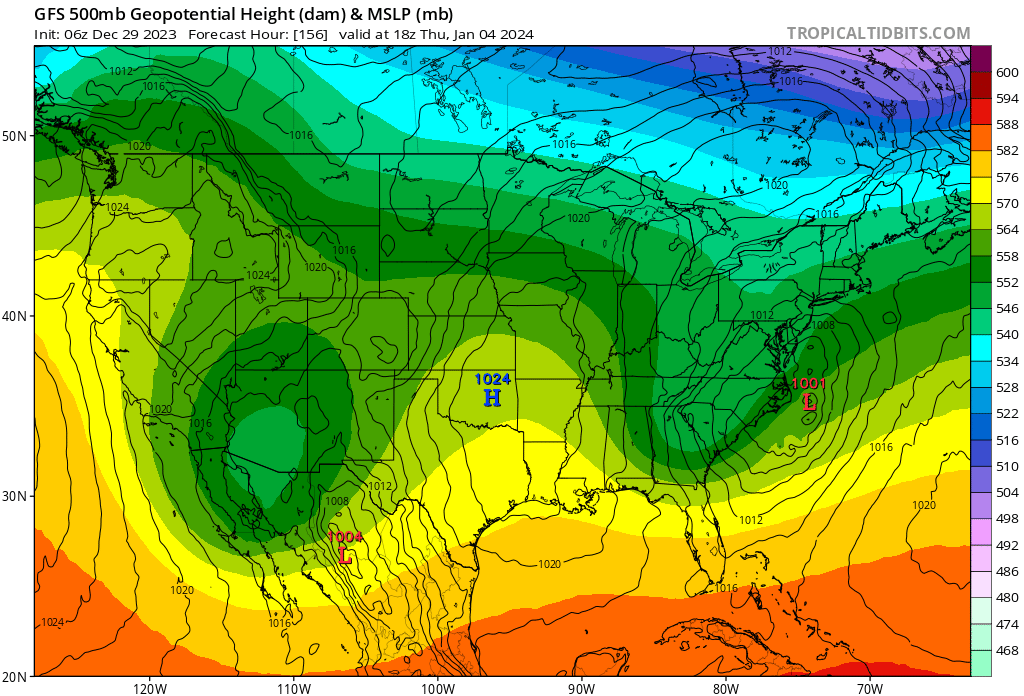
I'm hoping that this catches the Maritimes as well. We watch.
-
Most if not all capital cities in Canada will not have a white Christmas, including some traditionally cold areas like the prarries. My wife is from Winnipeg and is going home for Christmas. No snow otg and temps in the 40’s for Saturday. Green Christmas assured. Very unusual for them.
-
When we finally hit the good period, Watch it be cold and dry.
We need that first week of the month pattern back. Cold enough with s/w’s traversing under us. Shame we couldn’t have kept that going long before it went to shit. -
Seems like we have way more chances for screamers than snowers. Hope that turns around....and fast.
-
1
-
-
That was a full on Grinch. No question. Regardless of snow cover or not(Would've been even worse with more snow on ground). Just sucked the life out of the holiday mood.
-
What a dreadful look for Christmas on GFS. Raging rain storm with a raw warmish NE wind. Good god. Lets hope it's junk but with our luck, that will be the solution.
-
1
-
-
It's just amazing how consistently hostile things get either just before or on Christmas. Year after year no matter the pattern. Blows my mind.
-
1
-
Monitoring some form of significant ( to be determined more precisely) impact winter storm, Jan 16/17th. Moderate seems to be the upper limit - for now
in New England
Posted
Can someone post the 06z EPS please? for those of us who don't get that product.