deer
-
Posts
1,116 -
Joined
-
Last visited
Content Type
Profiles
Blogs
Forums
American Weather
Media Demo
Store
Gallery
Everything posted by deer
-
Lot of yellow and orange returns in WV / SW VA
-
35/6 Sun has disappeared
-
Seeing MBY in eastern Prince William essentially be the jackpot for the last 2 days means the Leesburg/central MD guys are gonna eat well this storm
-
I can see why normal people hate meteorologists
-
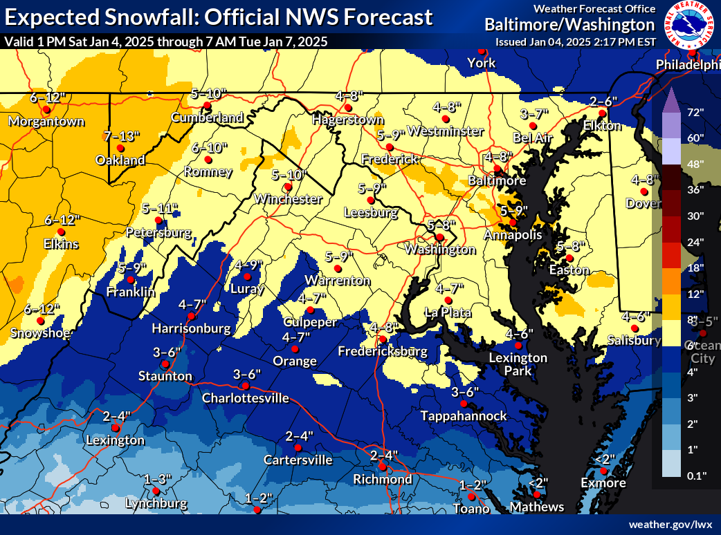
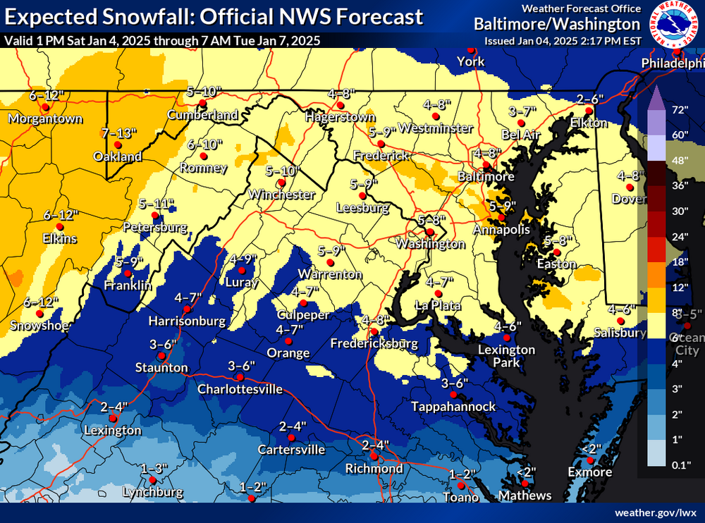
chatGPT summary: Short Term Weather Forecast (Sunday Evening through Monday Night) Overview: A weather system is approaching from the west, consisting of a closed upper low and a surface low that will move eastward from the Central Plains to the Mid-Mississippi Valley, then through the Ohio Valley, and overhead by Monday night. Precipitation Timeline: - Sunday Evening (6-9 PM): Precipitation will begin in the Alleghenies, central Shenandoah Valley, and central Virginia. - Late Evening (9 PM - Midnight): Northern Shenandoah Valley, DC/Baltimore Metros, and southern Maryland will see precipitation start. - After Midnight: Far northeast Maryland will begin to experience precipitation. Precipitation Type: - Initially, all precipitation will be snow, with intensity increasing quickly. - Expect snowfall rates of 1-2 inches per hour during the heaviest bands late Sunday night. Monday Morning: - Heavier precipitation will continue into Monday morning, tapering off late morning through afternoon as warm advection weakens. Monday Night: - The upper-level low will pass overhead, possibly leading to a secondary burst of moderate to heavy snow before precipitation winds down late evening/overnight. Model Guidance: - Bimodal Distribution: There is a split in model predictions regarding the system's track and precipitation amounts/types. - GFS/NAM Models: Suggest a more northern track with significant snowfall across the forecast area, potentially exceeding 6 inches in some areas. - Global Models (Euro, Canadian, UKMET, ICON): Indicate a southern QPF maximum, leading to reduced snowfall north of I-66/US-50, with advisory-level snowfall expected in those areas. Warnings: - A Winter Storm Warning has been issued for areas south of the I-66/US-50 corridor due to expected warning-level impacts from snow or a mix of snow and sleet/freezing rain. - A Winter Storm Watch remains in effect for northern Maryland and parts of the WV Panhandle due to uncertainty in precipitation amounts, which could range from advisory to warning levels. Conclusion: Monitor updates as the situation evolves, especially overnight after new guidance becomes available.
-
-
Seems like a hold for most of the area from 06z
-
90 people in the storm thread tonight!
-
1/3/25 - 0.25"
-
Heard it here too!
-
When I went to take a dump it was not snowing. Came out of the bathroom and the sky is ripping
-
I told myself this year I wasnt looking at this board until I saw snow falling from the sky. Surely showing up 2 days before our first good region-wide chance wont jinx anything! XD
-

The Weekend Rule? Saturday 2/17 - The Icon Storm
deer replied to DDweatherman's topic in Mid Atlantic
Looks like im staying up til 2am on Saturday! -
Jan/Early Feb Medium/Long Range Discussion Part 3
deer replied to WinterWxLuvr's topic in Mid Atlantic
4/30 with a foot+ for DC and very nearly a 5th. That's hot -
12/11: 0.5" 1/15-1/16: 2.8" 1/19: 3.0" Total: 6.3"
-
Still got some flurries going around 2.75" on the deck, spotter totals will probably be around 3" 5" in snow depth!
-
Accumulating again on my cleared areas HRRR says it'll be done here in the next hour or so 2.5"
-
Accumulation has been hard to come by here as well for the last 2 hours or so, even with decent returns. Would need to be in the yellows me thinks
-
Lighter green returns producing nice sized flakes in Lake Ridge. ~2.25"
-
2"
-
Just watched the back building start over Manassas, love to see it
-
Flake size just picked up