Snowcrazed71
-
Posts
2,540 -
Joined
-
Last visited
Content Type
Profiles
Blogs
Forums
American Weather
Media Demo
Store
Gallery
Everything posted by Snowcrazed71
-
You guys still think we'll see over 6" tomorrow later and night? I did get 1.5 today..and it's been pretty moderate to heavy sleet since.
-
I kid you not. He said he likes this model as it seems to be a solid model. I guess we will see though.
-
So... Gil Simmons.. A Met on WTNH in CT just did a live feed on FB. He said only to expect and inch or two tonight....and that most will get above freezing tomorrow during the day ( he said not to bank on closed schools ). He also say that round 2 tomorrow night might bring us 1-3 at the most. I think he is using the 3k NAM ( which he showed ). He seemed very confident that this will be the outcome.so, im guessing these snow maps from the Euro and HRRR aren't accurate. Well...at least we are getting the ground covered. :-)
-
As much as I would like to believe this, I just dont see us coming even close to that in CT. Especially after hearing what one of our METs from WTNH said. Ill post in a second. I would however, love to be wrong!!
-
I agree guys.
-
Okay..i thought that to, thanks
-
The thing I'm a little baffled at is they have northern Fairfield and Litchfield county under the Winter Storm Warning, but, left Hartford and Tolland counties a Winter Weather Advisory? With what I'm seeing..we should be anywhere between 8-12"?
-
Very exciting. Ya think they will finally upgrade us to Winter Storm Warnings?
-
Another next door neighbor. Howdy
-
YES!!! NOW THAT'S A WEENIE MAP. hoping they will finally flip us over to a Winter Storm Warning now ( oh..and there still is round 2, right? )
-
I sure am. I'm a stone's throw from you, so, I would tend to think what you see, I see. This storm had changed so much I've become numb to what will really happen. Lol
-
Ps...what's up neighbor.
-
And round 2?
-
Can anyone post the RGEM?
-
I agree with you. Joe Furey is one of my most favorite and trusted meteorologists. He's passionate oh, really gets into the details, and shares it with his viewers. This just is not our storm
-
This storm is just not ours in Connecticut. And, hey.. Only 7 times of 6+" in over 123 years. This was a lot of angst over the last few days tracking this storm. I'm just going to sit back and watch the Albany area get the big snows! We Will see ours. We will!!
-
Our station in Ct.. Wtnh is now saying they are down playing the totals and that Monday will be mostly dry with light showers of snow sleet. 3-5 for my area. But, I'm seeing otherwise on here. What is going on?
-
But the 12z EPS trended much better for Connecticut
-
I totally agree. We're in the winners circle with even 1-3" at this point of the early season
-
Im not sure I would trust this for CT. It showed a snow hole with not much precip through the state. All we need is a subtle placement change for the new low, and, we will get more snow in the state. Patience my friends. I do believe we will be getting more than modeled. The precip should be more robust once Monday comes along.
-
Im guessing the GEM is on crack?!
-
Thanks man. I snap shot the one I posted. I'll admit.. It looked horrible.. Lol
-
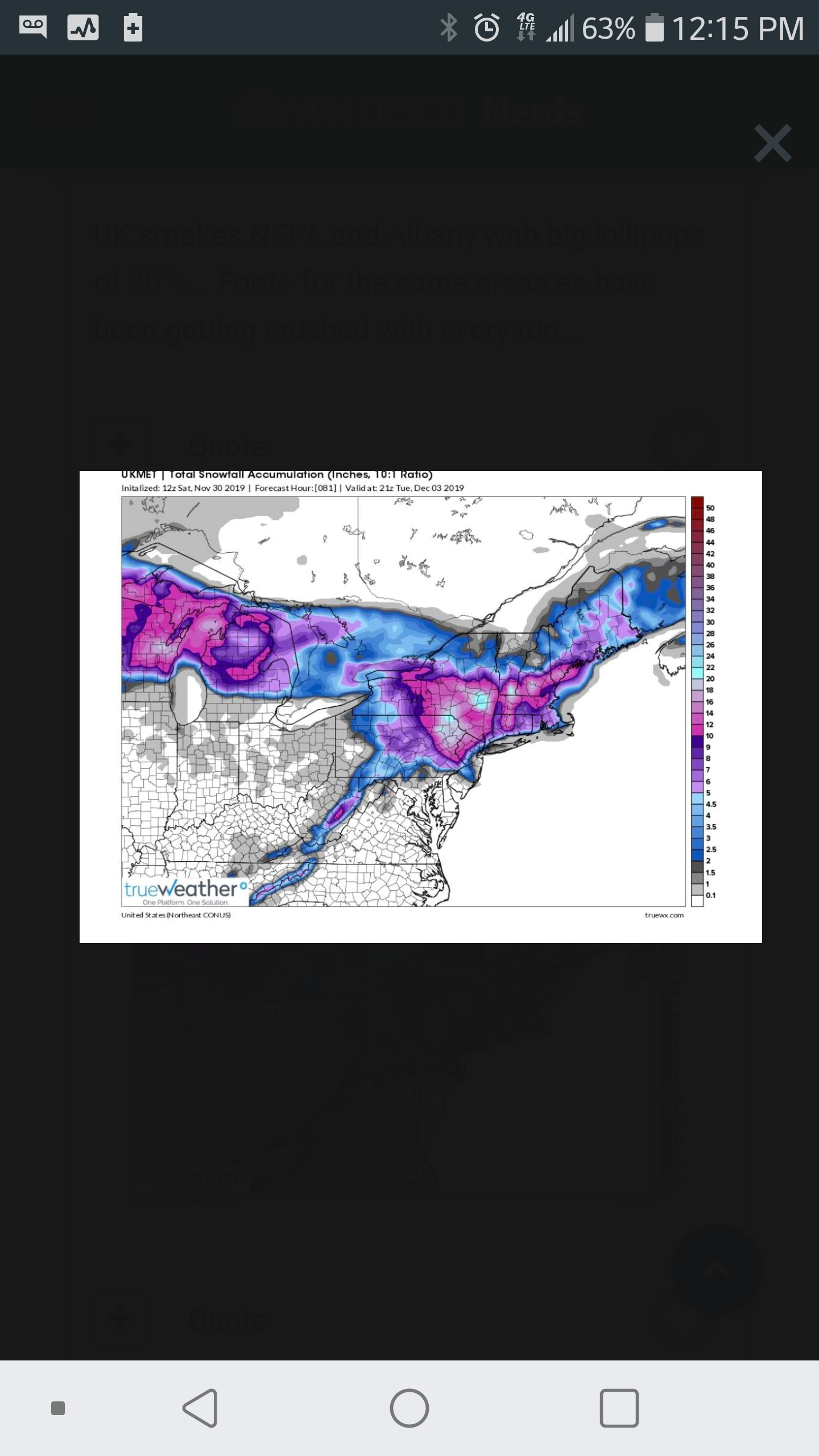
So.. The UKMET brings me back into the 12" range. Didn't someone mention it has done a good job so far with this storm. It definitely came south.
-
Good to see some slight trends back south and east on models. My gut is it will trend a bit more and get Connecticut back to a solid 5-10/6-12 for most of central and northern CT. Especially Monday afternoon and night.
-
Well.. 4"-8" is nothing to shake a stick at for December 1-2. Yes... It kind of is a let down when they had the bigger Snows into most of CT. Could it shift east slightly at the last second? Maybe. But, if that happens, we will only be surprised and excited for that shift. In the end... This is still a great way to get Snoe for the rest of the North East Region. There will be more, and , with this set up...we should have our turn in Southern New England. Im still excited for this one!