miamarsden8
-
Posts
114 -
Joined
-
Last visited
Content Type
Profiles
Blogs
Forums
American Weather
Media Demo
Store
Gallery
Everything posted by miamarsden8
-
Would 20:1 give us better snow totals or?
-
After the kuchera euro, if we are to trust they fixed the bug, 12 inches is possible in Cincy. I am terrified of another NW shift though, it's getting too close to those lower amounts for me.
-
Like I work for a call center IT company, right, and it's based in the south. I never would have imagined in my lifetime I'd see Texas being 100 percent covered in WSWs.
-
I think this is before the last couple of eastward bumps. Regardless, these percentages seem low.
-
I was, I moved out to Cincy about a year and a half ago to try to get better opportunities. I also get much less fun weather out here...until this year.
-
Welp, I'm getting nervous. This is not how I wanted to wake up at all! Stop trending northwest dammit! Seriously, I am on the north side of Cincy, but based on these trends I'm glad I called 6-10. I'm not sure we get there.
-
So meanwhile, in Cincy, they're calling 9-12. I'm still not mega convinced, I'm in the 6-10 range, but even 6-10 with any wind would be a disaster out here. We may be in the bullseye, folks. Here's hoping we hit the jackpot!

-
So meanwhile, in Cincy, the threat grows...high confidence for 6+ inches.
-
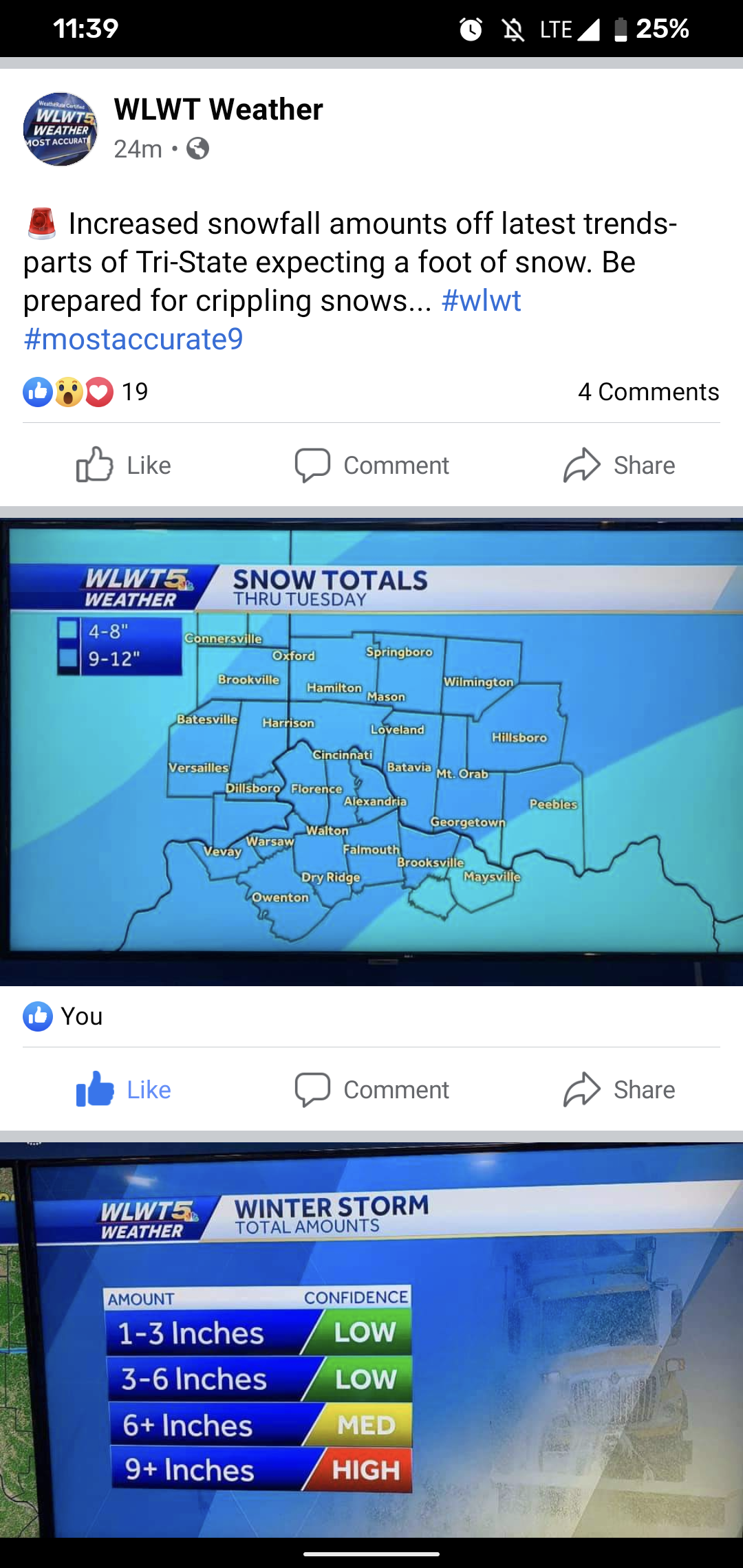
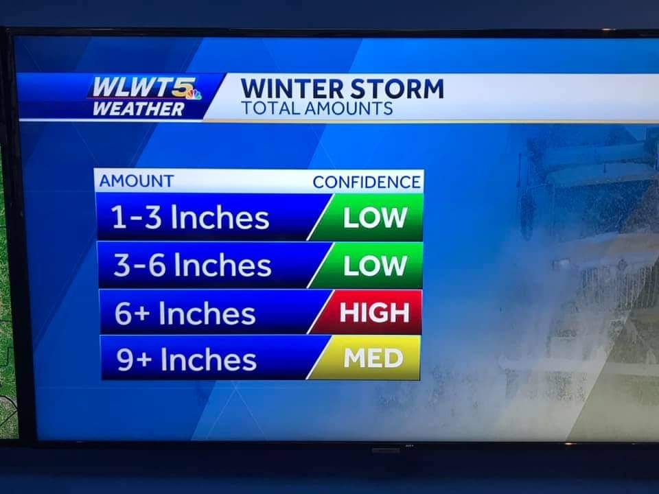
From the ILN area... ...WINTER STORM WATCH IN EFFECT FROM SUNDAY EVENING THROUGH TUESDAY AFTERNOON... * WHAT...Heavy snow possible. Total snow accumulations of 4 to 8 inches. Some sleet and freezing rain may mix in with the snow across South Central Ohio and Northeast Kentucky. * WHERE...Portions of East Central and Southeast Indiana, Northeast and Northern Kentucky and Central, South Central, Southwest and West Central Ohio. * WHEN...From Sunday evening through Tuesday afternoon. * IMPACTS...Travel could be very difficult. The hazardous conditions could impact the morning or evening commute. PRECAUTIONARY/PREPAREDNESS ACTIONS... Monitor the latest forecasts for updates on this situation. Yep, I'm riding this. Only thing that could screw us is if it warms up too much, but I'm feeling this one. 4-8 is a fair amount, but I wouldn't be stunned if it's more. All I know is that I told my s/o that Cincy has weak, boring winters. I have for one year been proven wrong.
-
January 30-February 1 Winter Storm Part 2
miamarsden8 replied to Hoosier's topic in Lakes/Ohio Valley
My call as of the moment is 2-4 for the Cincinnati area. I don't buy above that because only a couple models have tracked in that direction, but I also don't buy that this will be a dusting of snow because of the way the temperatures are running colder. But I have got to move north again one day. I miss western Illinois snowstorms. At least 6-8 inches is fun and we'd get 20 inch weenie runs sometimes to be excited about. -
January 30-February 1 Winter Storm Part 2
miamarsden8 replied to Hoosier's topic in Lakes/Ohio Valley
Reading through these forums, it's depressing moving from the Western Illinois University area, where we see at least some weenie number from time to time, to the Cincinnati metro area, where we're riding the line between 2 and 6 inches. Can we get a 20 mile south Euro shift? Doubtful, but I can hope.