ChiTownSnow
-
Posts
746 -
Joined
-
Last visited
Content Type
Profiles
Blogs
Forums
American Weather
Media Demo
Store
Gallery
Everything posted by ChiTownSnow
-
Seems like HRRR timing is much faster/earlier?
-
Plumes for ORD back up to 0.67 mean qpf. Not all snow verbatim but that can be argued a bit IF all snow, figure mean 7 inches at 10:1. Add in better ratio per LOT at 20:1 for a bit, and can easily argue the 6-10
-
LOT mentions the below caveats In their discussion 1). The leading and secondary troughs phase more than currently anticipated, leading to the surface low path much further northwest than advertised. In this scenario, a much larger portion of area would end up with a cold, wet rain with the southern edge of the snow roughly along a line from Dixon to Waukegan. While displayed by NAM/SREF guidance, we (as well as WPC) believe this outcome is unlikely. 2). Convective episodes across the Lower Mississippi River Valley muddy the surface low pressure pattern leading to a more "sheared" out wave and less forcing overall. While this would not necessarily shift the zone of anticipated accumulating snow, eventual amounts would end up lower than in our forecast (more in the range of 3-5" instead of 6"+). We saw this occur with a similar-looking storm system in February 2020. Of the two possible failure modes, this appears more realistic.
-
Wait. Didn't really materialize
-
Secondary wave playing catch up. Maybe similar to what EURO was showing earlier
-
Ha.. It's more about the trajectory and duration of the event
-
I've learned to be happy with a 5 inch total
-
We need a something to eject that secondary wave out earlier to catch up with the primary. Not sure on all the tech speak
-
Might be close.. I'm sure they have insurance for it.
-
I was just kidding..i didn't know if they still did that stuff either.
-
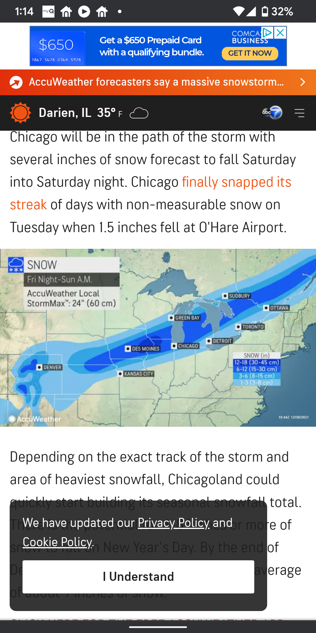
Or u can go all out like the AccuWeather map..

-
Plumes have a Mean qpf of 0.75 at ORD. But has some of that falling as a mix or rain which brings down the snow total mean. If it stays all snow I would agree 6-10 possible with the higher ratio snow falling at backside.
-
3-7. Highest north and near lake
-
I'll take the NAM qpf with the GFS track
-
I want my free car dammit... Throw me a bone.
-
It's like the snow map is miss aligned from surface map.. seems odd
-
More importantly, it looks juiced
-
Are plumes at 10:1 ?
-
Impressive skillz
-
Hopefully that doesn't steal our defo
-
Pretty good difference in temps. Temps colder with this run
-
https://www.spc.noaa.gov/exper/sref/srefplumes/ A little early for this I guess.. but Arp-1 please
-
Idk.. That lake is mighty warm. Not sure how much that might impact it
-
Seems to have a hard time ejecting out into the plains
-
POLL: 2021-2022 Season Snowfall Total @ ORD
ChiTownSnow replied to cyclone77's topic in Lakes/Ohio Valley
Too soon man..too soon