ChiTownSnow
-
Posts
746 -
Joined
-
Last visited
About ChiTownSnow

Recent Profile Visitors
2,399 profile views


-
CMC seemed to have a good handle on the WAA thump that came through for Chicago area.. it does have it ramp up a bit quicker to give us hope for tomorrow
-
im bowing out on the WAA thump.. dont see it materelaizing. see ya'll for severe weathe season.
-
if it smells like a rat, its a rat. i am out on this one. hoping for 1-2 WAA thump tonight.
-
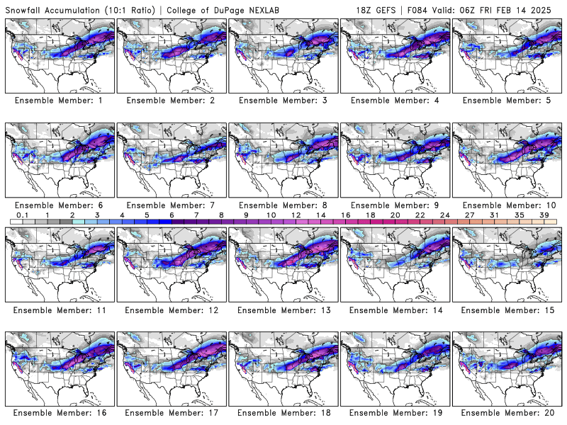
Klot not biting yet...great write up Saturday through Thursday: In the wake of the lead shortwave trough and slug of warm air advection driven precipitation Friday night, attention will turn to the large positively tilted upper trough moving across the region Saturday and Saturday night. The 12z operational ECMWF and GFS both depict precipitation breaking out somewhere in the region Saturday afternoon and evening near the northern terminus of the vort max associated with this trough. While the "look" of the QPF in the models suggests the presence of a developing TROWAL-driven deformation zone, that doesn`t seem to be the case with still an open wave at 700mb and a very baggy, weak closed low at 850mb. A deeper dive into what is driving this precipitation points toward some progressive mid- level frontogenesis, with some pretty substantial differences among the models and their respective ensembles regarding the placement of this QPF with non-trivial number of EPS and GFS ensemble members dry along with the 12z NAM. ECMWF and GFS both show a brief window of favorable upper jet support as 300mb jet streak on the leeward side of the trough strengths, but then our area quickly ends up in the convergent left entrance region of the jet. Hard to rule out some mesoscale driven banded beefier precipitation developing associated with the corresponding mid-level front. The GFS does show some rather strong transient 700-500mb frontogenesis over the region Saturday afternoon and evening. The operational ECMWF would suggest a flaring up of f-gen driven precipitation Saturday evening, which would stand a better chance to be snow, which could theoretically prove to be a better chance at some accumulations as temps would colder by then. The other realistic scenario for Saturday into Saturday evening would be very little measurable precipitation with just some drizzle and/or freezing drizzle. Given the exceedingly low confidence, opted to stick with straight NBM output which has snow and rain across the area Saturday afternoon and Saturday night. The categorical (>80%) NBM pops are higher than what I would have gone with, but confidence is lacking to lower them, particularly with so many models showing precipitation. By late Saturday night into Sunday morning, polar front jet is progged to begin phasing with the subtropical jet with a healthy northern stream shortwave digging into the backside of this trough. Steepening low-level lapse rates in the strengthening cold air advection regime along with this approaching trough could set the stage for some snow showers late Saturday night into Sunday, mainly the first half of the day. - Izzi
-
It's GFS's time to shine..
-
Gefs ensembles have some good members.
-
Winter 2024-25 Medium/Long Range Discussion
ChiTownSnow replied to michsnowfreak's topic in Lakes/Ohio Valley
Gonna have that 'spring feel' to it this week. -
Chicago can't even do lake effect right this year..
-
It's odd.. it's like the trajectory is shifting to more SW to NE but the snow accum map hasn't
-
3k nam keeps that H tucked back in Canada a bit more I agree it's not prime time yet for the nam here...but it is out west
-
Yesterday i would have taken 3 and run with it.. all LE?
-
Trajectory is much different.. but kinda feel we are grasping at this point
-
NAM Northern energy seems a bit stronger and H in Canada weaker/slightly more north @same hour
-
Yeah..I have been watching that tiny wave ahead of it to see if it does the same
-
End of nam run