LeesburgWx
-
Posts
1,501 -
Joined
-
Last visited
Content Type
Profiles
Blogs
Forums
American Weather
Media Demo
Store
Gallery
Everything posted by LeesburgWx
-
1/19 - The Roulette Wheel 29 Black Storm - OBS
LeesburgWx replied to DDweatherman's topic in Mid Atlantic
Damn, that band coming into Loudoun is aimed right at me. Looks heavy! -
1/19 - The Roulette Wheel 29 Black Storm - OBS
LeesburgWx replied to DDweatherman's topic in Mid Atlantic
That dark yellow coming into Southwestern Loudoun right now looks legit -
1/19 - The Roulette Wheel 29 Black Storm - OBS
LeesburgWx replied to DDweatherman's topic in Mid Atlantic
Ripping again. Just took a Jeb walk with the kids. Beautiful out. Loving life right now -
1/19 - The Roulette Wheel 29 Black Storm - OBS
LeesburgWx replied to DDweatherman's topic in Mid Atlantic
Rocking moderate snow again -
1/19 - The Roulette Wheel 29 Black Storm - OBS
LeesburgWx replied to DDweatherman's topic in Mid Atlantic
Sirens everywhere now off RT 7 after that band rolled through. Was heavy heavy snow -
1/19 - The Roulette Wheel 29 Black Storm - OBS
LeesburgWx replied to DDweatherman's topic in Mid Atlantic
This #5 for snow on snow. What a 2 weeks of winter this has been! -
1/19 - The Roulette Wheel 29 Black Storm - OBS
LeesburgWx replied to DDweatherman's topic in Mid Atlantic
Wow, absolutely dumping here! SN+ -
1/19 - The Roulette Wheel 29 Black Storm - OBS
LeesburgWx replied to DDweatherman's topic in Mid Atlantic
Ripping here and roads turning white. That was fast once the change happened. LFG! -
1/19 - The Roulette Wheel 29 Black Storm - OBS
LeesburgWx replied to DDweatherman's topic in Mid Atlantic
ok, its straight ripping now! -
1/19 - The Roulette Wheel 29 Black Storm - OBS
LeesburgWx replied to DDweatherman's topic in Mid Atlantic
coming down nicely here in Hamitlon. Decent rates but you can still see the edges of the flakes are missing -
1/19 - The Roulette Wheel 29 Black Storm - OBS
LeesburgWx replied to DDweatherman's topic in Mid Atlantic
Was under a heavier band for a bit. Now back to drizzle. Rocking a balmy 35-36 atm -
1/19 - The Roulette Wheel 29 Black Storm - OBS
LeesburgWx replied to DDweatherman's topic in Mid Atlantic
Mostly snow here now -
1/19 - The Roulette Wheel 29 Black Storm - OBS
LeesburgWx replied to DDweatherman's topic in Mid Atlantic
Is it over before it even started? -
URGENT - WINTER WEATHER MESSAGE National Weather Service Baltimore MD/Washington DC 1246 PM EST Sat Jan 18 2025 MDZ003>006-502-507-VAZ028-030-031-505-507-WVZ051>053-190200- /O.CON.KLWX.WS.W.0005.250119T1200Z-250120T0000Z/ Washington-Frederick MD-Carroll-Northern Baltimore-Central and Eastern Allegany-Northwest Harford-Frederick VA-Warren-Clarke- Western Loudoun-Northern Virginia Blue Ridge-Morgan-Berkeley- Jefferson- 1246 PM EST Sat Jan 18 2025 ...WINTER STORM WARNING REMAINS IN EFFECT FROM 7 AM TO 7 PM EST SUNDAY... * WHAT...Heavy snow expected. Total snow accumulations between 3 and 6 inches with locally up to 8 across the higher elevations of northern Maryland. * WHERE...Portions of north central, northern, and western Maryland, northern and northwest Virginia, and panhandle West Virginia. * WHEN...From 7 AM to 7 PM EST Sunday. * IMPACTS...Travel could be very difficult. The hazardous conditions will impact travel. * ADDITIONAL DETAILS...Snow will overspread the area Sunday morning and continue through the afternoon before tapering off during the evening. Snowfall rates could approach 1 inch an hour at times. Temperatures will fall into the teens Sunday night so any lingering moisture on area roadways will freeze.
-
This is and always has been a Loudoun special. But anymore movement NW and even Loudoun is in trouble
-
Raining right now. Trying to hold as much snow cover as possible until tomorrow‘a snow and then the freezer coming
-
6” would beat the last storm for me where I only got like 5.5” - but I still have the snow cover. Going for 5x snow on snow tomorrow
-
That’s a Loudoun special right there
-
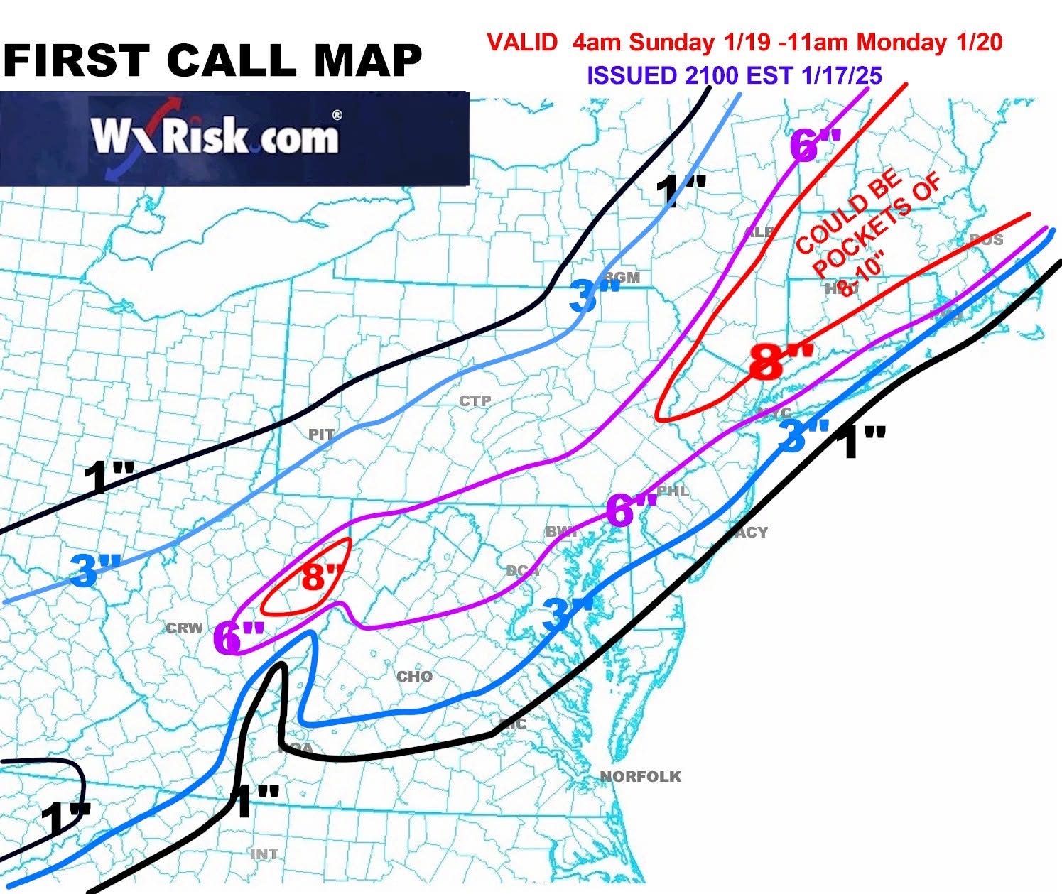
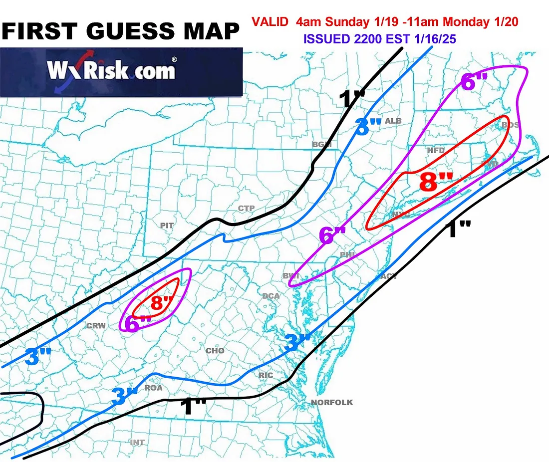
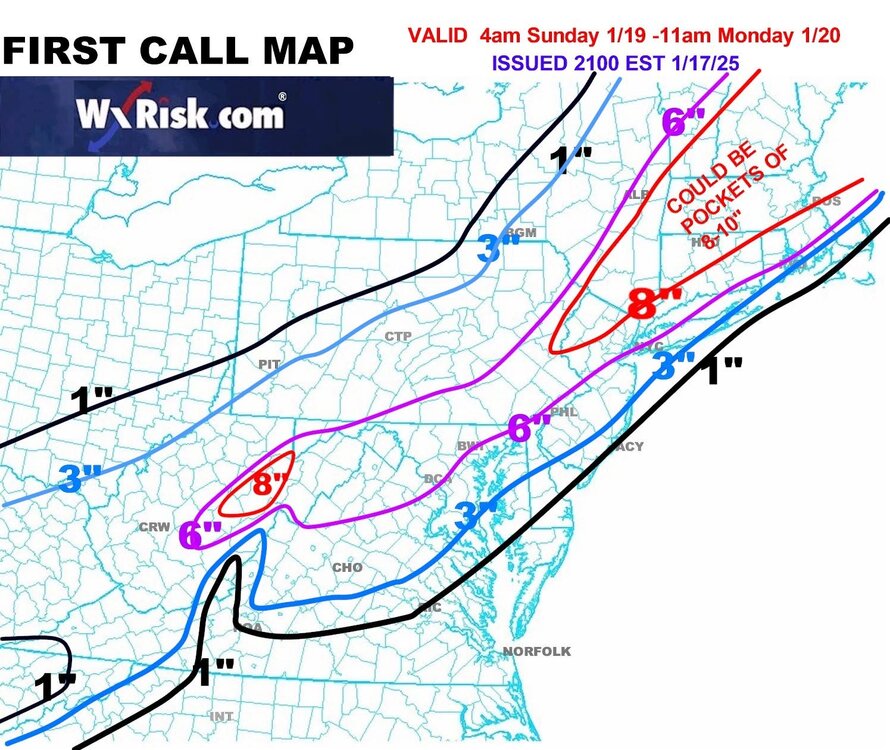
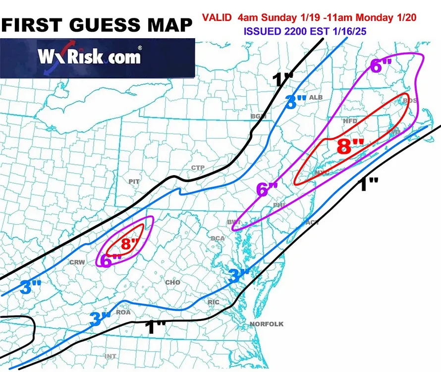
Not a bad map from DT
-
I don’t get it. Are you bi-polar? One second, your posts are reasonable and good. The next, they end up like this.
-
This is the type of storm where I am happy I live in Western Loudoun - need to get some 4-6" lollis out here soon
-
Winter Storm Watch! LFG - Heavy snow wording is gorgeous
-
GFS is gorgeous! When the 10:1 even shows 6", you are golden
-
Acceptable
-
Looks like another band about to roll into Loudoun shortly