

mattny88
-
Posts
92 -
Joined
-
Last visited
Content Type
Profiles
Blogs
Forums
American Weather
Media Demo
Store
Gallery
Everything posted by mattny88
-
Feb 2-4th Snowstorm- Observation Thread
mattny88 replied to BuffaloWeather's topic in Upstate New York/Pennsylvania
Wonder if news Channel 9 will increase there snow totals as well in there 5pm news broadcast based on the latest model runs? I tend to notice they always seem a tad conservative with there totals vs nbc3 and news channel 5...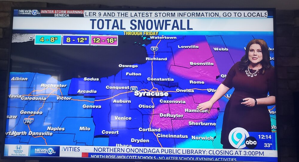
-
Upstate/Eastern New York-Into Winter!
mattny88 replied to BuffaloWeather's topic in Upstate New York/Pennsylvania
WSYR NEWS CHANNEL 9 newest updated snowfall map for tonight... based off this map looks like they have adjusted the highest snow totals and bullseye for the lake effect band to set up over southern oswego county into the night
-
Upstate/Eastern New York-Into Winter!
mattny88 replied to BuffaloWeather's topic in Upstate New York/Pennsylvania
WSYR local meteorologist are calling for 1-3 as the band oscillates and then it looks like they went with more of the southern model run of a band setting up shop over eastern cayuga/southwest onondaga. i am with you tughillmatt, my name is matt as well and i just relocated last year from oswego down here to liverpool right off soule rd about a minute from rte 31...being new to the route 31 corridor, what kind of wind is the best setup for us that can produce a stationary band that doesnt jump right over us? Is there any historical archive maps of northern onondaga county that reflect past big pure lake effect events other then nws maps..i would assume a west to north west wind with more towards a northwest wind would be almost ideal..i was accustomed to oswego getting the winds on a west to slightly west north west wind. but i tended to find that oswego had to have pretty light calm winds for a big time stationary band to set up over the city of oswego... i drive daily from liverpool to oswego and traveling up 481 the fulton/volney area always seems to be the sweet spot..let me know your thoughts with this storm regarding snow amounts and in general for northern onondaga. Also if anyone can help me out and repost what i had seen a picture of from a good while back. it was a picture of the direction of the wind flow it had different arrows coming off the lake and for each arrow it showed the degree of wind flow for each angle. would like a picture to relate to when the national weather service discussion talk about the wind direction degree relating it to my area.. Thanks everyone
-
Upstate/Eastern New York
mattny88 replied to BuffaloWeather's topic in Upstate New York/Pennsylvania
Hey tughill just measured 4.5" not to far from you as i live off soule rd in liverpool..what site do you watch the webcam locations at! We had a lull for past 30 minutes but now its definitly starting to come down again -
Upstate/Eastern New York
mattny88 replied to BuffaloWeather's topic in Upstate New York/Pennsylvania
Per the NWS they just upgraded to a winter storm warning for oswego county...6-12 inches..Wolfie i live within the city of oswego..do you think our location is a tad to far north to get into the real deformation banding zone that they are calling for down south closer to the syracuse area..i just didnt know if that westward jog on the models brought the heavier precip. further northwest to include the lake shore communities..how much you projecting snow amounts for us.. -
Upstate/Eastern New York
mattny88 replied to BuffaloWeather's topic in Upstate New York/Pennsylvania
hey guys,so i live in the city of oswego and out of the nws buffalo AFD the sentence what caught my eye was "with a single plume of heavy snow likely across Oswego county".. with that said how much you think we are talking about..intensity wise of the band and the duration and snowfall amounts?...im assuming there will be a wnw or westerly component to the wind?? the city of oswego usually does will when the winds are lighter being we are right on the lake..some lake effect strorms tend to blow right over us..also was seeing if you guys could post an image or two of the models lake effect run for tuesday evening after the synoptic storm passes..thanks guys -
Upstate/Eastern New York
mattny88 replied to BuffaloWeather's topic in Upstate New York/Pennsylvania
hey guys just wanted to see what the weather is looking for going into next week as the colder air pushes in..is first flakes and/or synoptic/any lake effect snow chances a reality.. i live up here in oswego ny and just am curious because its getting to be that time of year again. I am wanting to start up the chatter and model runs to see the possibilities thanks guys!! -
Upstate/Eastern New York
mattny88 replied to BuffaloWeather's topic in Upstate New York/Pennsylvania
hey there syrmax..looking into relocating in phoenix...is the phoenix area more comparable to fulton or clay (route 31 corridor) when it comes to lake effect snowfall.. i know its sandwiched right in between the two as the transient town from which route 481 connects them i just didnt know what your experience has been like living in clay vs phoenix and in relation to fulton....didnt know if that wnw lake band that desposits over fulton usually extend down into phoenix most of the time during the 2-3 ft lake storms that fulton receives from time to time??

