.jpeg.fb71a75fc71475b59e72598d4a9a6f88.jpeg)
TJW014
-
Posts
800 -
Joined
-
Last visited
Content Type
Profiles
Blogs
Forums
American Weather
Media Demo
Store
Gallery
Everything posted by TJW014
-
.thumb.jpeg.f5c6ba9d911ec96b3b124f8606aee58e.jpeg) There's a reason Freehold is the CNJ snow capital lol
There's a reason Freehold is the CNJ snow capital lol -
Yep, I think we get two distinctive bands with this. One situated on either side of I-95, the other just NW of US-202 and I-287. Bit of a subsidence screw zone in between the two.
-
Power's out. Again. Same area. 5th time this month.
-
Bullseye for me lol
-
It satisfies the whole subforum with a plowable snow. Everybody wins.
-
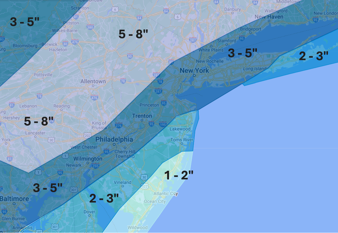
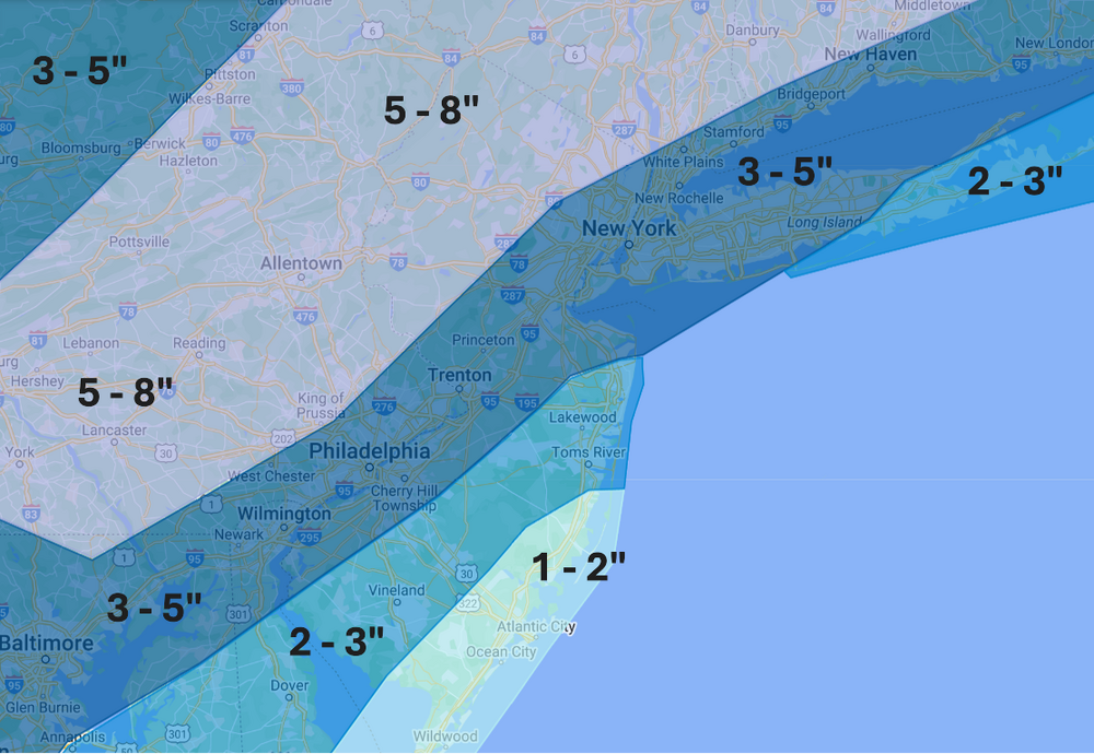
LOL accidentally uploaded the wrong map. Map update: Not too much has changed aside from bumping up totals slightly for pretty much everyone. Looks to be a decent event for 98% of us. I still think the coast mixes initially, but otherwise I'm pretty confident we see an all-snow event for I-95 and NYC.
-
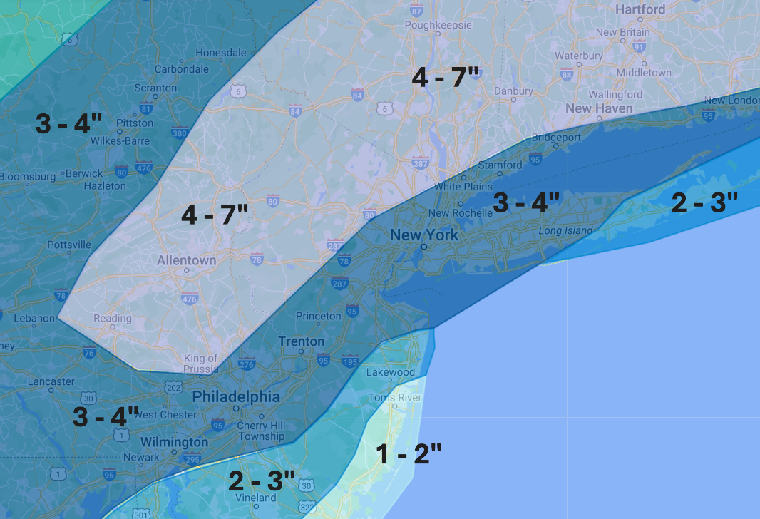
Will update/adjust my snow map pending the Euro. As of now, doesn't look like I'll be making any changes except maybe broadening the 4 - 7" section and maybe bumping totals a little bit more
-
150 miles west 48 hours prior to start time isn't "slightly" west
-
-
Amazing that we are 24 - 30 hours from go time and we still have a 150-mile spread
-
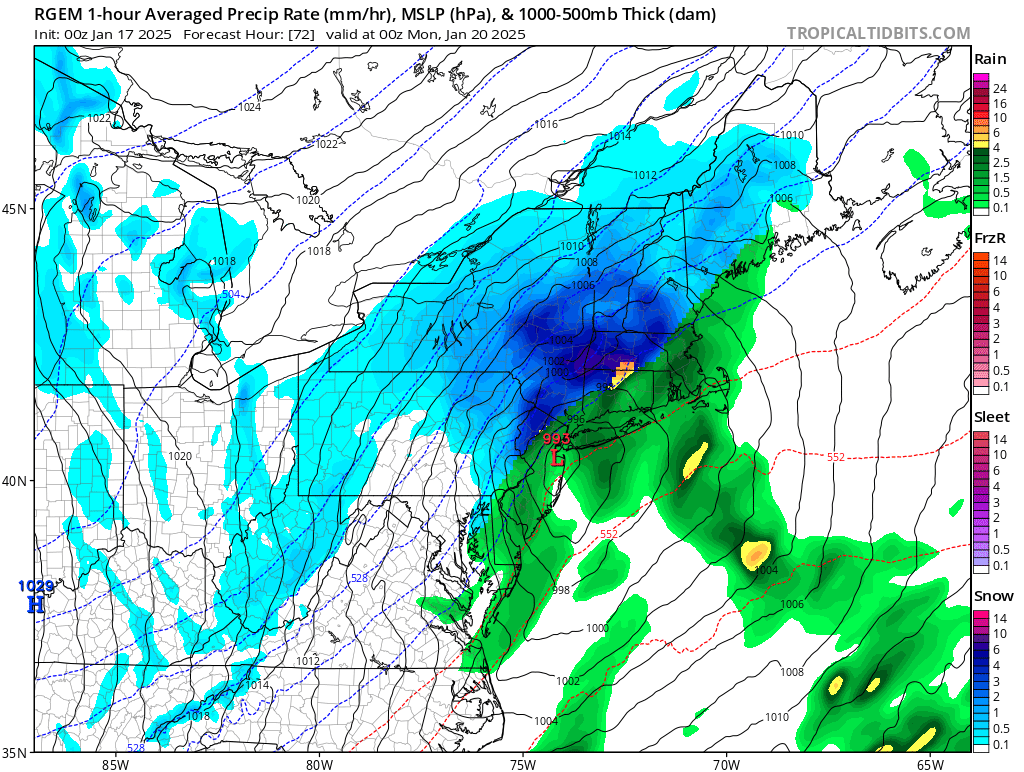
Snow from start to finish for everybody on the NAM.
-
IMO GFS is slightly overdone and Euro slightly underdone. Middle ground would be a good bet for now
-
A broken clock is still right 2X a day...
-
Has me torching in the 50s
-
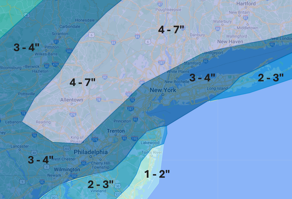
Said f*** it and made a map. For the most part, discounting RGEM/GGEM. I believe it is too strong/amped and will cave to the SE. If it doesn't, a lot of us are going to be unhappy. Pretty confident on a rain/mix at the start for the NJ Coastal Plain (more so here) and some for E Long Island too. Otherwise, I went with a blend of GFS, Ukie, and Euro. Think it comes a bit farther west and lightly stronger/juicer than the Ukie/Euro, but not to GFS/GEM amounts. Overall think it's a good 3 - 4 - 5 inch event for most of us, except for extreme south/east spots. Given the speed of this thing, I think the upper limit is 7, maybe 8 inches somewhere just NW of 287. Aside from the coast, ratios should be increasing as the storm progresses, highest farther NW, up to 15:1. Feel free to roast, criticize, wring me by the neck, etc.
-
Saquon and the tush push will be neutered.
-
One of the reasons why the metro area is such a difficult spot for everyone to cash in. What's good for one can screw someone else.
-
I'd be ecstatic with the Ukie run
-
Paste job for here
-
There's the inevitable shift northwest that always happens
-
Well out of range, HRRR has rain north of I-287
-
Still unchanged from my view of this being a rainstorm for coastal Monmouth/Ocean County + Eastern LI. Thinking the gradient line sets up along I-95/278/Belt Pkwy
-
Reggie with a rainstorm for NYC with the briefest changeover to snow for an hour at the end.

-
NAM at this range is about as useful as my girlfriend trying to decide what she wants for dinner.
-
I'm going to be the Debbie Downer I am and say that I expect this to be more of a rain event than a snow event here. The last place I want to be is already flirting with the R/S line 3 days out, especially given the inevitable final adjustment northwest that we always get. I fully expect a changeover to snow as the low pulls away but not after 85% of the precipitation fell as rain. This will probably be one of those Congrats Freehold Twp events