.jpeg.fb71a75fc71475b59e72598d4a9a6f88.jpeg)
TJW014
-
Posts
800 -
Joined
-
Last visited
Content Type
Profiles
Blogs
Forums
American Weather
Media Demo
Store
Gallery
Everything posted by TJW014
-
.thumb.jpeg.f5c6ba9d911ec96b3b124f8606aee58e.jpeg) Looks about a 30 mile shift to the north. NYC and LI see 0.3" qpf. About 0.5" qpf right over me
Looks about a 30 mile shift to the north. NYC and LI see 0.3" qpf. About 0.5" qpf right over me -
Only frozen precipitation so far has been road salt. Milking that overtime down here. Rain continues
-
Straight rain here. Not even a ping. Started about 10 minutes ago.
-
KDOX/KDIX radars filling in. Looks wetter than the NAM and HRRR are showing. Stop looking at maps. Now is the time for radar/obs
-
Sitting at 30 right now. Sun breaking through the clouds as well. But it was always going to be a sleet to rain event here.
-
NYC would probably have over a 100" seasonal average if Day 5-10 maps verified every time.
-
Try coastal Ocean County
-
Something vs nothing line is going to set up along the Monmouth/Middlesex County line
-
I'd rather a whiff than these snow to slop to rain events. Been either too far north or too far south this winter so far. Ocean County snow hole doing it's thing.
-
Peak gust of 53 mph on the bayfront here
-
Worth mentioning we finally dipped below zero this morning. Down to -2. Last two mornings were 9 and 13.
-
On track here for the driest January on record. Sitting at .29" (inc. melted snow). I believe the record for NJ is 0.51" in 1981. Someone can correct me if I'm wrong
-
Flurries have started
-
This will continue to pivot northwest. City may be in on some flakes. Might get more out of this than last night (1.75")
-
Absolute ripper of a band about to pivot through
-
Radar really filling in off the Jersey Shore
-
More mix with this next ripple of precip moving through
-
Still holding steady at 35. High was forecast to be 41. Max today was 38.5 at midnight
-
Radar beginning to fill in down here. Tiny stripe of precip passing through. Couple fat flakes and raindrops mixed.
-
Ironically the barrier island is running about 2-3 degrees colder than the mainland by me. Looks like temps have plateaued here.
-
Temps slowly climbing but dews holding steady, if not falling slightly. 35/29. Think the Arctic front is pushing offshore now as there's a noticable wind shift out of the NW.
-
App sucks. Use it on my phone because the website on Chrome has pop-ups covering everything. Ads everywhere on Tapatalk too and the scrolling is terrible.
-
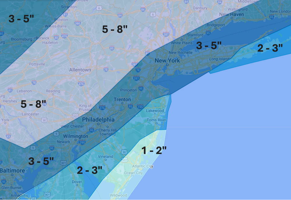
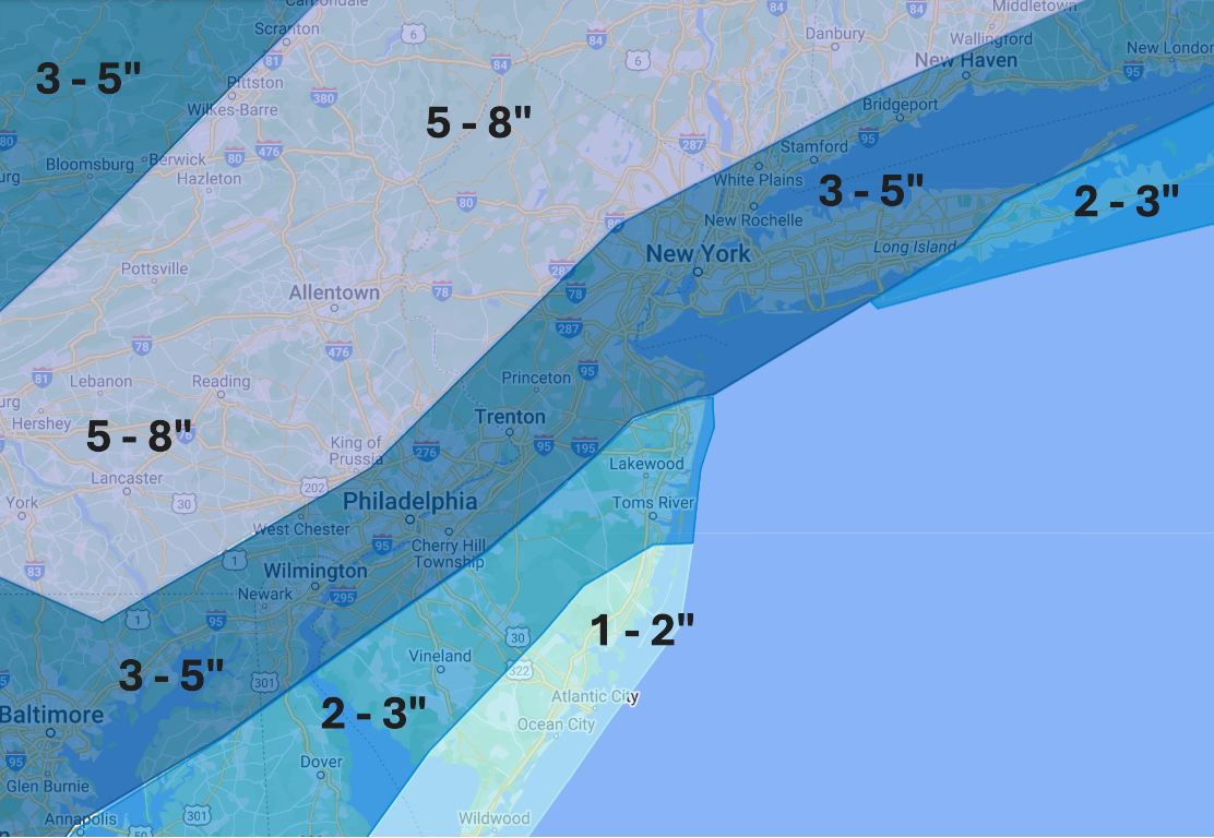
Final call: No changes from yesterday afternoon to my map. I'm not buying into the NAM/GFS/HRRR hype, but think it's worth taking note of them being solutions if we have an all-snow event. Otherwise, it's a plowable snow for all that will be sticking around for a long time given the bitter cold arriving. Worth noting there may be a screw zone somewhere on either side of I-95 due to subsidence between heavier bands. Likewise, anyone sitting under these heavy bands could pick up an extra inch or two if they remain stationary. Coastal areas will likely still have mixing issues at onset. Enjoy everyone!