.jpeg.fb71a75fc71475b59e72598d4a9a6f88.jpeg)
TJW014
-
Posts
800 -
Joined
-
Last visited
Content Type
Profiles
Blogs
Forums
American Weather
Media Demo
Store
Gallery
Everything posted by TJW014
-
.thumb.jpeg.f5c6ba9d911ec96b3b124f8606aee58e.jpeg) Starts between 5-7 AM, wrapping up by 8-9 PM for most. Evening commute might be interesting
Starts between 5-7 AM, wrapping up by 8-9 PM for most. Evening commute might be interesting -
Big winner will somehow be Freehold, NJ. Seems like they always end up squeezing out a little more than anybody else.
-
Sea robin is delicious. Had some on my last visit to FL. Fried with a coconut batter. Easily top 3 fish meal I've eaten. They're related to lionfish, which is also very good eating.
-
East of the GSP, particularly the barrier islands might have some trouble with mixing with the easterly wind. Ocean temps are still in the mid-upper 40s (44091 is 46.5) Early call is 2" here. Could be more, could be less depending on where the Norlun trof sets up.
-
Definitely concerned about the flash freeze potential tonight. Much of us get down to the teens with wind chills near zero. Even treated roads may ice up.
-
Took a ride into IBSP. Up to 37 degrees here. Rain with a few sleet pellets mixing in. About an inch less right along the beach. Windier than I expected. 25 sustained, gusts up to 35 mph.
-
Just flipped over to sleet. 3.5" on the ground here along the bayfront. Heavier band pushing through in a few minutes, might flip it back to snow. Otherwise think that's about it for me here. Side residential roads are a little slushy but main roads have more visible asphalt than not.
-
A hair over an inch here on the grass and car tops. Starting to stick to untreated roads.
-
Light snow reaching the ground here in Toms River. Sticking to the grass and boat cover. Ahead of schedule.
-
35 was our forecast high here today, still sitting down at 28. Definitely has that "it's gonna snow" feel in the air.
-
I personally love events like this. Just enough to make everything look pretty outside and coming down at a rate slow enough that the roads don't become a nightmare. Seems like all we ever get now is either 8 inches or more or 2" of rain. I'd much rather have 10 of these events than just one blockbuster storm all winter. That all said, little concerned with temps here right along the Shore. If we stay cold, expecting about 2" here.
-
Two Mdt to high impact events NYC subforum; wknd Jan 6-7 Incl OBS, and mid week Jan 9-10 (incl OBS). Total water equiv by 00z/11 general 2", possibly 6" includes snow-ice mainly interior. RVR flood potential increases Jan 10 and beyond. Damaging wind.
TJW014 replied to wdrag's topic in New York City Metro
From OKX that's 90 miles away. Beam height is 8000 feet @0.5 tilt. Same velocities (some even higher) can be seen on DIX radar too. -
Two Mdt to high impact events NYC subforum; wknd Jan 6-7 Incl OBS, and mid week Jan 9-10 (incl OBS). Total water equiv by 00z/11 general 2", possibly 6" includes snow-ice mainly interior. RVR flood potential increases Jan 10 and beyond. Damaging wind.
TJW014 replied to wdrag's topic in New York City Metro
From KDIX radar, 110 mph velocities are at a beam height of 2500 feet, 30 miles away from the radar. . -
Two Mdt to high impact events NYC subforum; wknd Jan 6-7 Incl OBS, and mid week Jan 9-10 (incl OBS). Total water equiv by 00z/11 general 2", possibly 6" includes snow-ice mainly interior. RVR flood potential increases Jan 10 and beyond. Damaging wind.
TJW014 replied to wdrag's topic in New York City Metro
I installed that station there at the bathhouse pavilion when working for the state. Guess I mounted it in a really nice spot.- 3,610 replies
-
- 3
-

-
- snow
- heavy rain
- (and 5 more)
-
Two Mdt to high impact events NYC subforum; wknd Jan 6-7 Incl OBS, and mid week Jan 9-10 (incl OBS). Total water equiv by 00z/11 general 2", possibly 6" includes snow-ice mainly interior. RVR flood potential increases Jan 10 and beyond. Damaging wind.
TJW014 replied to wdrag's topic in New York City Metro
62 mph in Barnegat Bay- 3,610 replies
-
- 1
-
-
- snow
- heavy rain
- (and 5 more)
-
Two Mdt to high impact events NYC subforum; wknd Jan 6-7 Incl OBS, and mid week Jan 9-10 (incl OBS). Total water equiv by 00z/11 general 2", possibly 6" includes snow-ice mainly interior. RVR flood potential increases Jan 10 and beyond. Damaging wind.
TJW014 replied to wdrag's topic in New York City Metro
Sustained 64 mph with a peak gust of 75 mph at Cape Fear, NC -
Two Mdt to high impact events NYC subforum; wknd Jan 6-7 Incl OBS, and mid week Jan 9-10 (incl OBS). Total water equiv by 00z/11 general 2", possibly 6" includes snow-ice mainly interior. RVR flood potential increases Jan 10 and beyond. Damaging wind.
TJW014 replied to wdrag's topic in New York City Metro
Wind gusts already to 35 mph on the marshes in Barnegat Bay.- 3,610 replies
-
- 1
-
-
- snow
- heavy rain
- (and 5 more)
-
Two Mdt to high impact events NYC subforum; wknd Jan 6-7 Incl OBS, and mid week Jan 9-10 (incl OBS). Total water equiv by 00z/11 general 2", possibly 6" includes snow-ice mainly interior. RVR flood potential increases Jan 10 and beyond. Damaging wind.
TJW014 replied to wdrag's topic in New York City Metro
This will be a fun flight home from RSW - EWR tomorrow night.- 3,610 replies
-
- 2
-

-
- snow
- heavy rain
- (and 5 more)
-
Two Mdt to high impact events NYC subforum; wknd Jan 6-7 Incl OBS, and mid week Jan 9-10 (incl OBS). Total water equiv by 00z/11 general 2", possibly 6" includes snow-ice mainly interior. RVR flood potential increases Jan 10 and beyond. Damaging wind.
TJW014 replied to wdrag's topic in New York City Metro
Well, it seems to just be my fantastic luck that I will be out of state for 10 days, so of course it'll snow at home. I spent winter 2021-22 in Florida and Jan/Feb 2022 was a great time for snow on the Jersey Shore. -
Moderate-High Impact Storm Noon Sun Dec 17, 2023 - 4PM Mon Dec 18. Flooding rain I95 corridor northwestward, coastal tidal flooding, brief periods of damaging 50 MPH+ wind gusts LI/CT Monday, ends as a little wet snow interior elevations Tue morning.
TJW014 replied to wdrag's topic in New York City Metro
https://www.wpc.ncep.noaa.gov/metwatch/metwatch_mpd_multi.php?md=1206&yr=2023 -
Moderate-High Impact Storm Noon Sun Dec 17, 2023 - 4PM Mon Dec 18. Flooding rain I95 corridor northwestward, coastal tidal flooding, brief periods of damaging 50 MPH+ wind gusts LI/CT Monday, ends as a little wet snow interior elevations Tue morning.
TJW014 replied to wdrag's topic in New York City Metro
Of course my do decides to wake me up to go use the bathroom when the rain is at its heaviest. Nasty out right now. Almost feels tropical. Peak wind gust of 57 mph so far. Nearby PWS at the beach peaked at 62 mph a few min ago. I come back inside and well, what do ya know? The roof is leaking. Smh.- 489 replies
-
- 1
-

-
- flooding rains
- coastal flooding
- (and 4 more)
-
Moderate-High Impact Storm Noon Sun Dec 17, 2023 - 4PM Mon Dec 18. Flooding rain I95 corridor northwestward, coastal tidal flooding, brief periods of damaging 50 MPH+ wind gusts LI/CT Monday, ends as a little wet snow interior elevations Tue morning.
TJW014 replied to wdrag's topic in New York City Metro
Steadier rains falling now. First gust over 40 mph at the beach (41 mph). KDIX radar velocities showing 70 mph above me (1000 feet beam height) -
Moderate-High Impact Storm Noon Sun Dec 17, 2023 - 4PM Mon Dec 18. Flooding rain I95 corridor northwestward, coastal tidal flooding, brief periods of damaging 50 MPH+ wind gusts LI/CT Monday, ends as a little wet snow interior elevations Tue morning.
TJW014 replied to wdrag's topic in New York City Metro
Sustained 22-25 mph with gusts around 30 mph here at the beach since 9:30 AM (Seaside, NJ) -
Moderate-High Impact Storm Noon Sun Dec 17, 2023 - 4PM Mon Dec 18. Flooding rain I95 corridor northwestward, coastal tidal flooding, brief periods of damaging 50 MPH+ wind gusts LI/CT Monday, ends as a little wet snow interior elevations Tue morning.
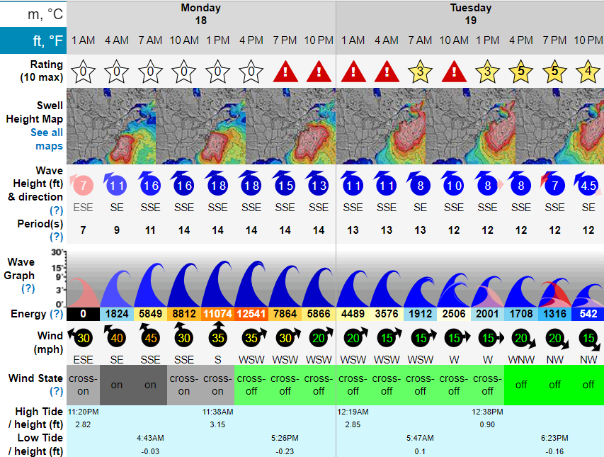
TJW014 replied to wdrag's topic in New York City Metro
Surf Forecast for Westhampton Beach (Cupsogue). Swell energy is insane. Beaches are going to take a serious beating. Very lucky to not have to deal with Full/New Moon tides