Ecanem
-
Posts
129 -
Joined
-
Last visited
Content Type
Profiles
Blogs
Forums
American Weather
Media Demo
Store
Gallery
Everything posted by Ecanem
-
Western PA/Pittsburgh Winter 2021/22 Discussion
Ecanem replied to meatwad's topic in Upstate New York/Pennsylvania
I was 11. Probably thought it was a minor storm compared to 93. -
Western PA/Pittsburgh Winter 2021/22 Discussion
Ecanem replied to meatwad's topic in Upstate New York/Pennsylvania
What’s the closest analogy to this storm? Honestly I’ve been following storms since the accuweather forums and I just can’t remember one that has this much QPF -
Western PA/Pittsburgh Winter 2021/22 Discussion
Ecanem replied to meatwad's topic in Upstate New York/Pennsylvania
All this talk makes me question. Hrrr vs NAM. And then I found this. and im still confused -
Western PA/Pittsburgh Winter 2021/22 Discussion
Ecanem replied to meatwad's topic in Upstate New York/Pennsylvania
Is anyone as nervously excited that I am? My friends and family know me as the ‘weather guy’ asking me what I think is going to happen. I’m optimistic for a good snow but the 2019? WSW bust is still fresh in memory. -
Western PA/Pittsburgh Winter 2021/22 Discussion
Ecanem replied to meatwad's topic in Upstate New York/Pennsylvania
So I’m really wondering how much snow we’re gonna get here at seven springs. There’s always a few more inches than the forecasts. I’m wondering we we could go to 1-2 feet -
Western PA/Pittsburgh Winter 2021/22 Discussion
Ecanem replied to meatwad's topic in Upstate New York/Pennsylvania
Well if we are in the dry slot this early. That means we should be good come storm time. -
Western PA/Pittsburgh Winter 2021/22 Discussion
Ecanem replied to meatwad's topic in Upstate New York/Pennsylvania
I’ve seen some still question a coastal track. That seems so dead to me at this point. -
Western PA/Pittsburgh Winter 2021/22 Discussion
Ecanem replied to meatwad's topic in Upstate New York/Pennsylvania
I know you say this. But storms always seem to shift east at the last minute. At least we are in that zone now. -
Western PA/Pittsburgh Winter 2021/22 Discussion
Ecanem replied to meatwad's topic in Upstate New York/Pennsylvania
Gfs is very similar. -
Western PA/Pittsburgh Winter 2021/22 Discussion
Ecanem replied to meatwad's topic in Upstate New York/Pennsylvania
Gfs through 12z Sunday isn’t looking much different than 18z. The 500mb dips a little more into GOM. -
Western PA/Pittsburgh Winter 2021/22 Discussion
Ecanem replied to meatwad's topic in Upstate New York/Pennsylvania

-
Western PA/Pittsburgh Winter 2021/22 Discussion
Ecanem replied to meatwad's topic in Upstate New York/Pennsylvania
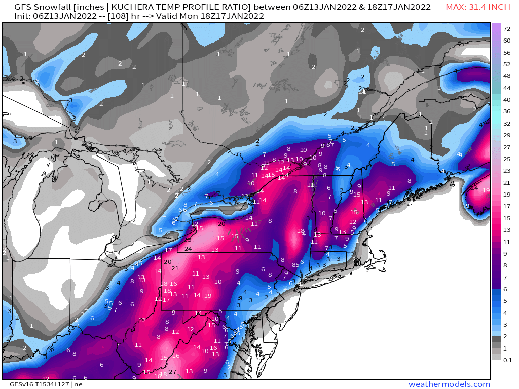
6Z GFS vs 00Z Euro, tracks arent that far off. 0Z Euro seems less amped. Both snow track and low location on Monday morning,.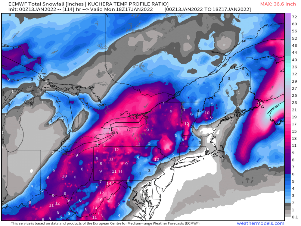

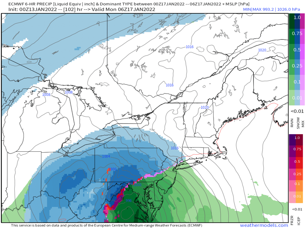
-
Western PA/Pittsburgh Winter 2021/22 Discussion
Ecanem replied to meatwad's topic in Upstate New York/Pennsylvania
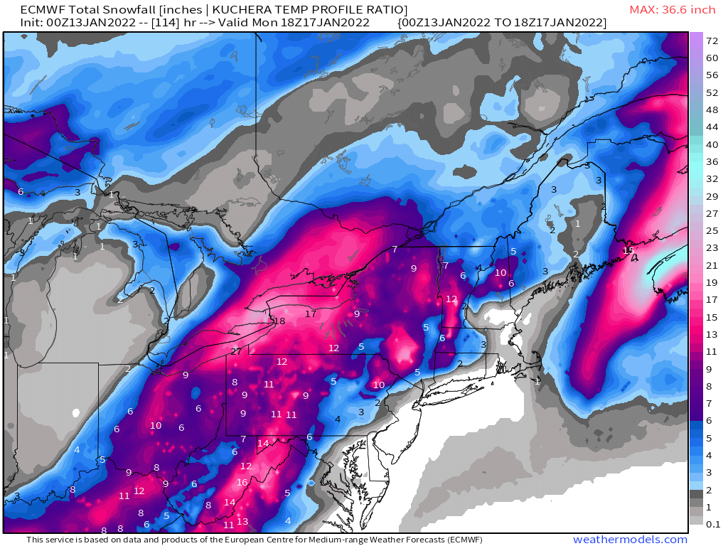
Seven Springs. Aka in that euro 22” zone. -
Western PA/Pittsburgh Winter 2021/22 Discussion
Ecanem replied to meatwad's topic in Upstate New York/Pennsylvania
Soooo I am going skiing this weekend.... really would stink to get 'snowed in' on monday and tuesday. -
Western PA/Pittsburgh Winter 2021/22 Discussion
Ecanem replied to meatwad's topic in Upstate New York/Pennsylvania
GFS 12Z rolling in is looking closer to 00Z looks a little stronger on the 500mb too. Let's see where it goes. -
Western PA/Pittsburgh Spring Discussion 2021
Ecanem replied to Ahoff's topic in Upstate New York/Pennsylvania
Didn’t realize we had a new thread. Posting for alerts. -
Western Pa / Pittsburgh area Winter Discussion ❄️☃️
Ecanem replied to north pgh's topic in Upstate New York/Pennsylvania
Shocked that this thread is dead after the snow today. My grass is almost completely covered. -
Western Pa / Pittsburgh area Winter Discussion ❄️☃️
Ecanem replied to north pgh's topic in Upstate New York/Pennsylvania
As a skier. This winter was an A+++++ probably too 1-2 of the last decade. -
Western Pa / Pittsburgh area Winter Discussion ❄️☃️
Ecanem replied to north pgh's topic in Upstate New York/Pennsylvania
I should be more clear, Monday Morning with the system. -
Western Pa / Pittsburgh area Winter Discussion ❄️☃️
Ecanem replied to north pgh's topic in Upstate New York/Pennsylvania
The NAM is really Bullish on the cold for Monday. -
Western Pa / Pittsburgh area Winter Discussion ❄️☃️
Ecanem replied to north pgh's topic in Upstate New York/Pennsylvania
Don't look now, but the Euro and GFS are sniffing another storm next Friday. -
Western Pa / Pittsburgh area Winter Discussion ❄️☃️
Ecanem replied to north pgh's topic in Upstate New York/Pennsylvania
Looks like we should get trickles throughout the day and night for another 1-2”. I only got 1.25” from last night -
Western Pa / Pittsburgh area Winter Discussion ❄️☃️
Ecanem replied to north pgh's topic in Upstate New York/Pennsylvania
Welp. It’s a WWA. We can expect about .5” of snow (this is sarcasm) -
Western Pa / Pittsburgh area Winter Discussion ❄️☃️
Ecanem replied to north pgh's topic in Upstate New York/Pennsylvania
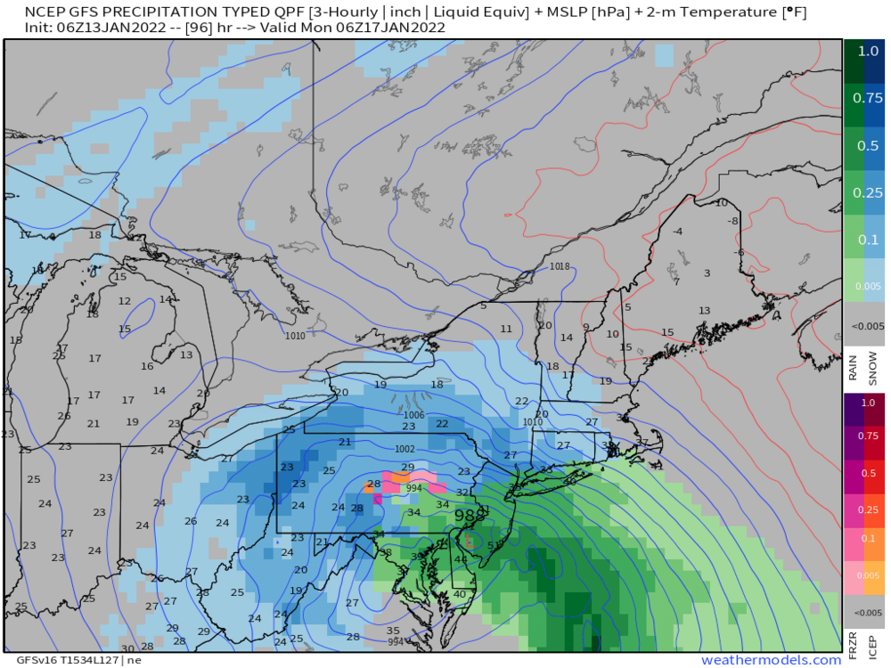
The NAM is a good 50+ miles north of both the GFS and the Euro as well as it has a much broader precipitation shield. Actually looking at the 12z model suites. NAM and HRRR are further north and again much broader precip shield whereas Euro has a huge cutoff and even leaves central PA out to dry. It's pretty amazing again how inconsistent these models are this close to the storm. -
Western Pa / Pittsburgh area Winter Discussion ❄️☃️
Ecanem replied to north pgh's topic in Upstate New York/Pennsylvania
GFS doesnt show major snow totals for us but it also brings the rain/sleet line almost to allegheny county.