RamblinRed
-
Posts
51 -
Joined
-
Last visited
About RamblinRed

-
That's a pretty view of Emory, Cheeznado. I'm in Canton so very likely no snow for me. My colleague in Buckhead says it is snowing there.
-
In fairness on 2014, since I lived through that - the roads went from drivable to ice rinks in about a 30 minute timespan. As soon as they iced everything became impassable because of accidents and the inability of cars to drive up icy hills. Thankfully I worked from home that day but I had teammates who went in to town to work and they got stuck on those roads. They brined the highways but it rained first and washed it all away. Then the temp dropped and the frozen precip started. There is a great time lapse somewhere of traffic in Atlanta that day. It went from every road being green to every road being red in about 45 minutes.
-
Alot of discussion from NWS Atlanta
-
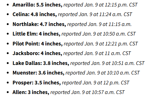
FWIW, here is a snowmap from NWS. Some pretty good totals just north of Dallas. Keeping the fingers crossed (all we can do at this point). https://www.weather.gov/source/crh/snowmap.html
-
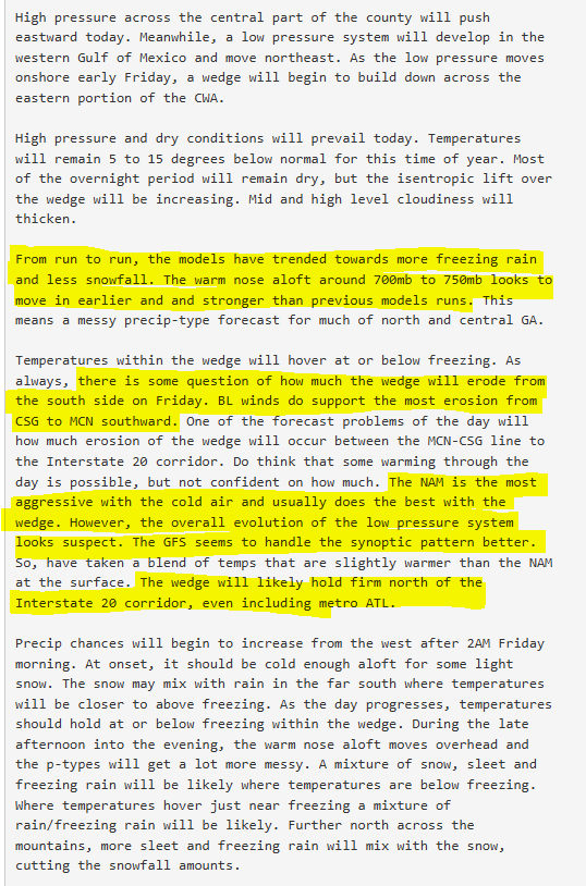
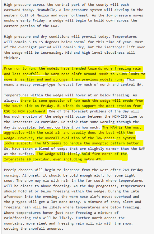
Discussion from the NWS Atlanta. I found it particularly interesting that it is mentioned that the NAM's overall evolution of the low is suspect and that the GFS has a better handle on the synoptic pattern.
-
Hopefully the moisture and temperature levels in the SE will be like what is showing in DFW right now (more moisture and lower temperature than what modeling is providing).
-
Watched the various ATL weather people this morning. Have definitely backed off the snow some here, now more playing up the ice potential. One station even talked about the warm nose. They have been moving up the start time here - as soon as 6 am for some, and also moving up changeover to freezing precip. More 12 pm now. For my area (Cherokee County) they seem to be thinking 2 inches of snow and then maybe .1-.2 ice. Yesterday forcast was 3-5, today 1-3. I suspect by later this afternoon all the metro schools will announce closings or remote learning days for Friday. I also expect almost all businesses to tell their employees to work from home. no one will want a repeat of 2014.
-
Either the Euro or UK would be pretty good for me. UK would give me 2-3" while the Euro would be 4+. Would be thrilled with either given 6 years of no snow.
-
Those Freezing rain totals would be disastrous for metro Atlanta. Roads would be impassable and the power outages would likely be high due to all the trees. I just want 3 inches of snow. Haven't had snow in 6 years here.
-
I'm in Cherokee Co, GA (NW ATL). Just hoping for 3+ here. We got a new sled after the 2018 storm and haven't had a chance to use it yet. Now in a development that has large hills. Son would have a blast if we get legit snow. My daughter is hoping for snow Friday so she doesn't have to drive downtown. May get her wish. That NAM run would create a huge mess from about Buckhead south to Macon with ice.
-
That run would give the northern ATL suburbs (Cherokee, N. Fulton, Forsyth, N. Gwinett, Hall) their biggest winter event in at least 5-6 years. Some snow with a good layer of freezing crap as well. That would definitely mess up that side of town.
-
https://www.washingtonpost.com/climate-environment/interactive/2024/southern-us-sea-level-rise-risk-cities/ For this analysis, The Post relied on tide gauge data, which reflects the rise in sea level and sinking of land. For example, Galveston, TX (Galveston Pier 21 gauge) has seen 6.1 inches of Sea Level rise from 1980 to 2009 and an additional 8.4 inches of sea level rise from 2010-2023. That's 14.5 inches in 44 years with the majority of the rise occuring in the last 14 years as the pace has increased. The Fort Pulaski guage outside of Savannah, GA has seen 7.3 inches of sea level rise in the last 14 years. (After 3.7 inches of rise in the previous 30 years). The most interesting part of their analysis is dividing it up by time. It allows you to see how much the rates of rise are increasing. Also interesting to note that the article goes into some detail it is not only sea level rise (that is the biggest part), but also the sinking of land. Finally, it is not consistent across the country, or the world. Some areas are seeing sea level rise at much faster rates than other areas. In the US it is the SE - particularly the Gulf of Mexico and the Southern Atlantic that is seeing the fastest sea level rise. The rates in that area are often 2-3 times faster than in the mid-atlantic or NE.
-
My wife's best friend has a home on Little Gasparilla Island that she shared with her sister. That home is now part of the Gulf of Mexico. The only thing left are the pylons the house was on. It was the third house from the beach. The two in front of it were destroyed by Helene and then their house was destroyed by Milton. There is still alot of loss from this hurricane and give the NHC credit for doing an incredible job with all its forecasting for this one. On the main thread they were discussing potential landfall at St. Pete as late as 4 pm that afternoon. It is only then that Milton started to take the hard right turn. If it had taken the turn 1-2 hours later we would have had a much worse story.
-
It also seems like the earlier a model projects landfall it seems to be slightly farther north. Maybe because that means less time for the East turn. CMC is the outlier there, but it has been a southern outlier the entire way. This just looks so close. One wobble to the North could put Tampa right in the cross hairs.
-
winds are starting to spread out Hurricane-force winds extend outward up to 35 miles (55 km) from the center and tropical-storm-force winds extend outward up to 175 miles (280 km). A NOAA saildrone (SD-1083) located approximately 80 miles northeast of the center recently reported a sustained wind of 44 mph (71 km/h) with a gust of 57 mph (91 km/h).