cptcatz
-
Posts
1,028 -
Joined
-
Last visited
Content Type
Profiles
Blogs
Forums
American Weather
Media Demo
Store
Gallery
Everything posted by cptcatz
-
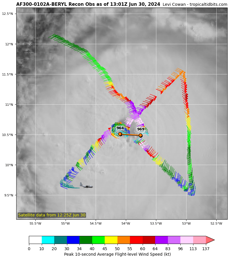
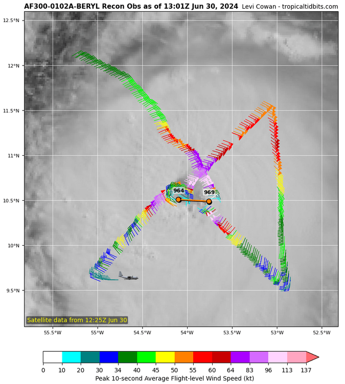
Recon just picked up its first hurricane force wind at flight level (66 knots). Satellite also showing big convection popping up around the eye...
-
I think you are analyzing this the wrong way. Again, the storm isn't a sentient being. Everything that has happened is because of physical occurrences that happened in the atmosphere. I don't think you can even say "this storm has done well in a high shear environment". There's a scientific answer to that, although I'm not sure what it is. Maybe the shear simply wasn't as strong as scientists think it was, or there's some other reason why this specific storm wasn't impacted by that specific shear in that specific environment. But all those specifics has nothing to do with what's happening right now a thousand miles away from that previous occurrence.
-
But the center is now back over water and it's a pretty good bit east.
-
Don't forget the two 2020 Greek storms that did this same thing. Delta went over the Yucatan and weakened to a cat 1, Zeta went over the Yucatan and weakened to a tropical storm, and both made landfall in Louisiana as major hurricanes...
-
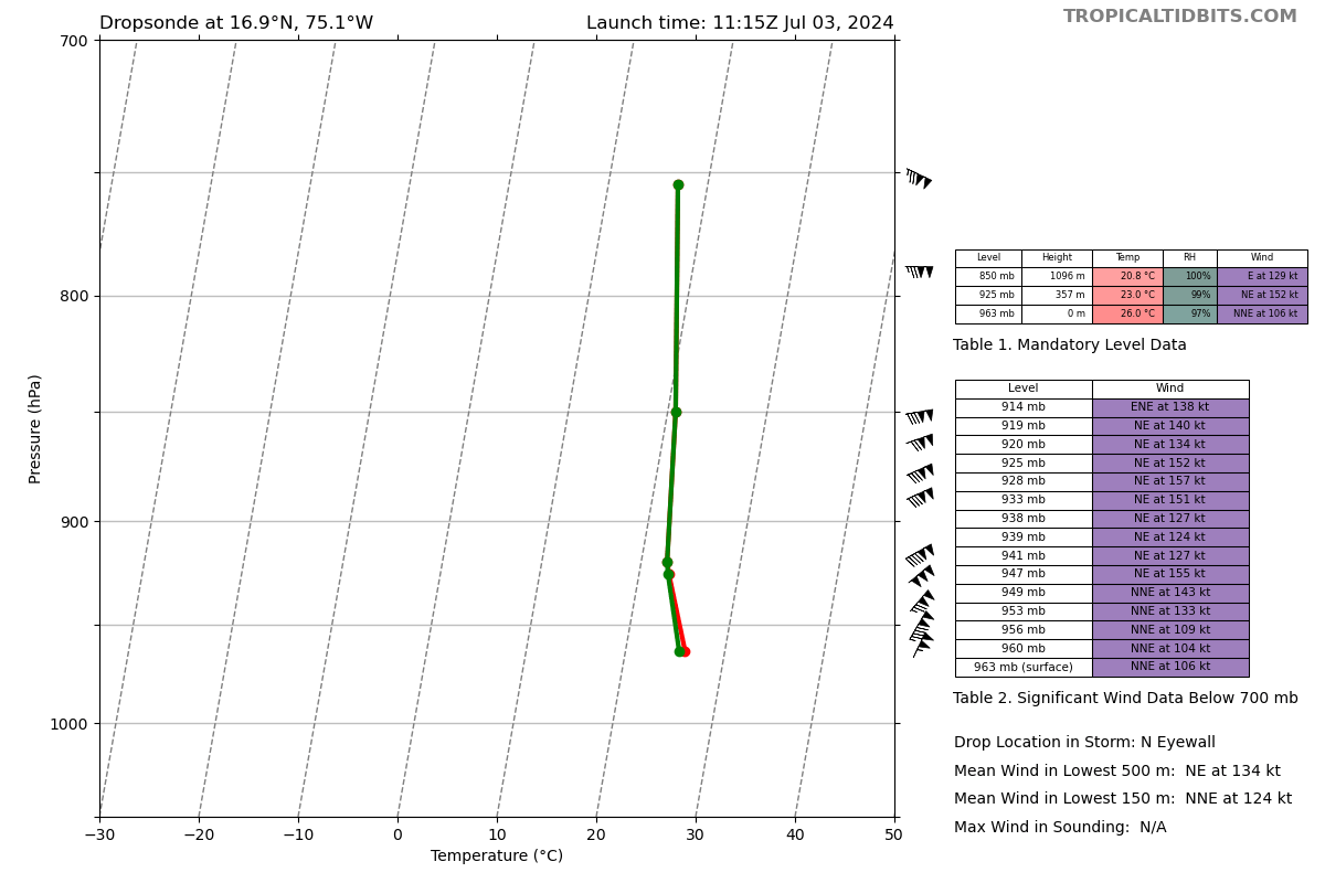
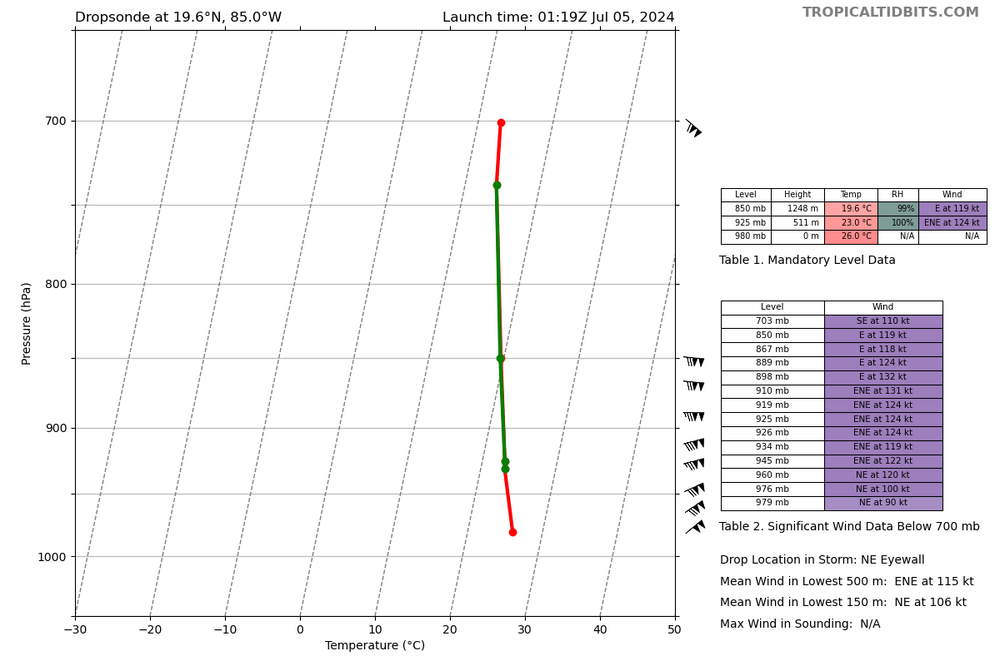
Impressive dropsonde from a storm that was supposed to be weakening
-
Still impressive dropsonde on the northern eyewall. Jamaica is in for it as it looks like it will get hit with that northern side.

-
2024 Atlantic Hurricane Season
cptcatz replied to Stormchaserchuck1's topic in Tropical Headquarters
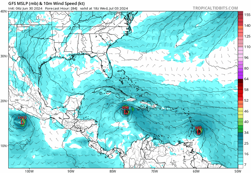
96L is still showing a nice big area of convection and models have it developing in the Gulf. Might need to keep an eye on that. -
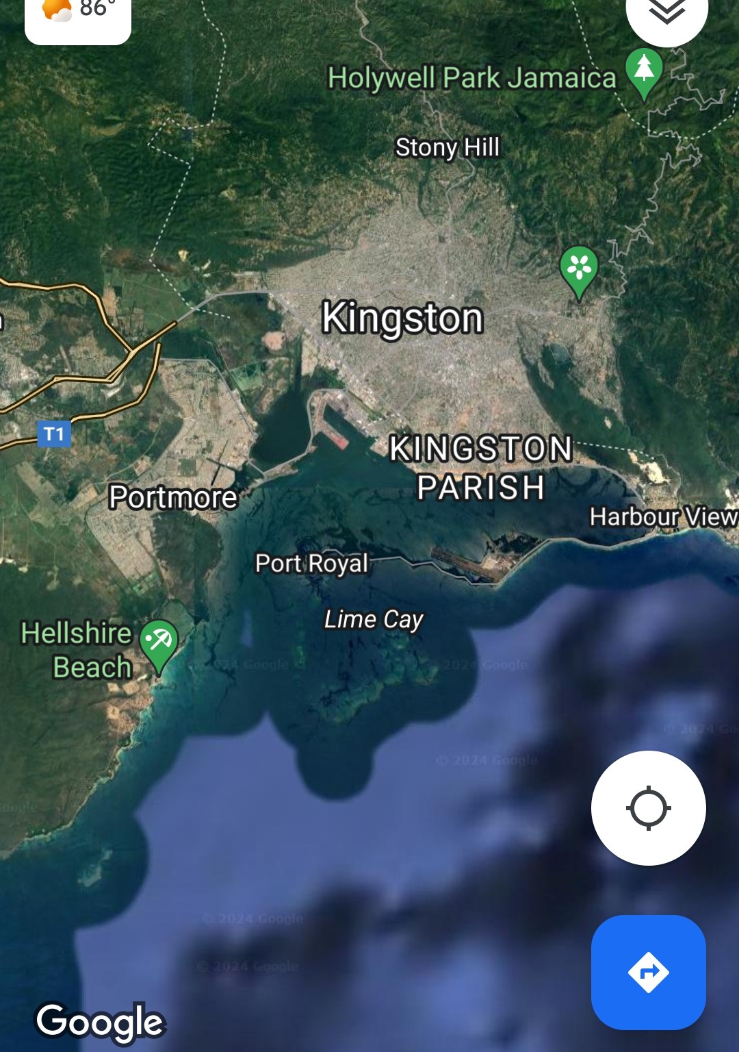
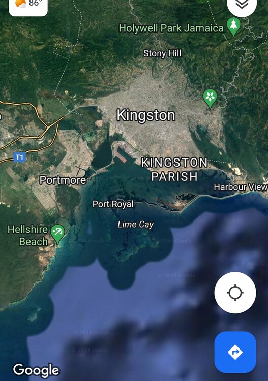
Not sure what you're talking about. The low lying areas of Kingston are incredibly surge prone to this exact track. If the north side of the storm passes over Kingston, it will pile up the water right into this bay.
-
Could be some catastrophic storm surge in Jamaica. Doesn't matter if it weakens at all at this point. The wall of water this thing is pushing on its north side is going to be massive. Absolute worst case scenario if Jamaica gets the north side.
-
Impressive dropsonde. Not sure I remember seeing a 170 knot gust in quite a while.
-
That's what people probably said about Dennis in 2005. Then Emily said hold my beer. Then Katrina said hold my beer. Then Rita said hold my beer. Then Wilma said hold my beer. Might we get one to beat Wilma?
-
130 knot FL wind on that northeast pass, pressure dropping. Oh boy...
-
955 mb on this new recon pass. NW winds no higher but we'll need to see the NE pass
-
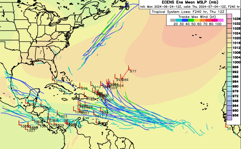
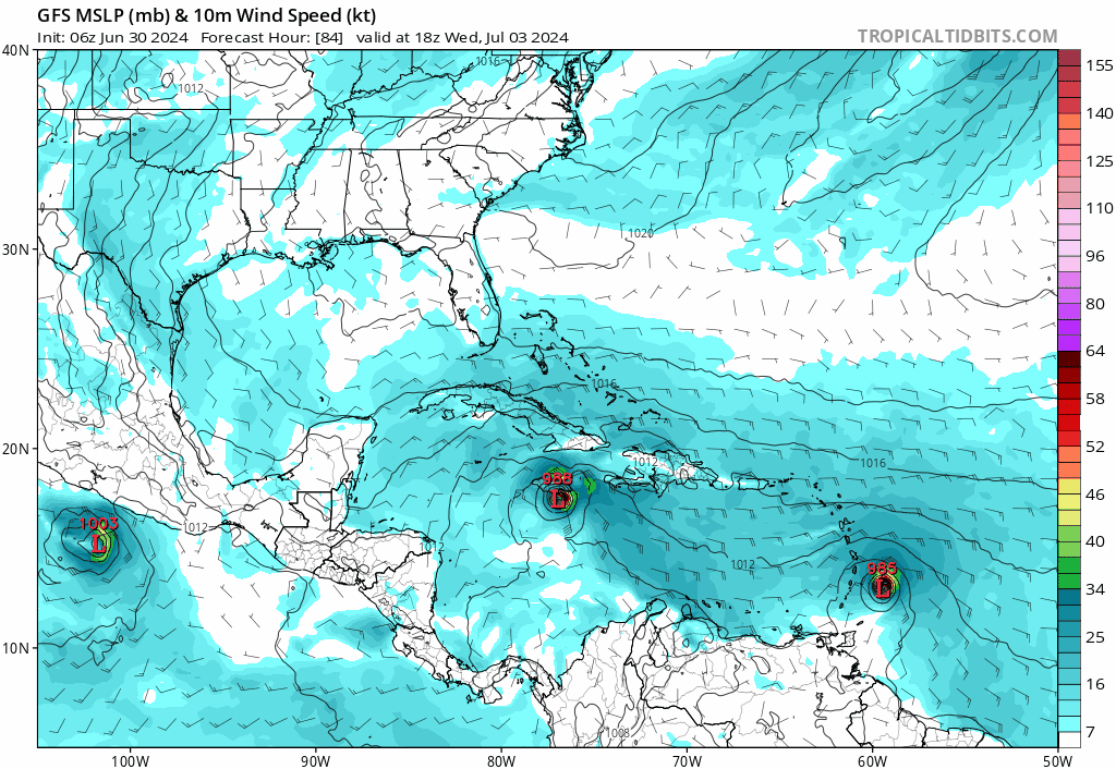
Euro initializes at 996, crosses the islands at 990, continues to deepen in the eastern Caribbean reaching Jamaica at a staggering 966, and then weakens. This is similar to what Icon showed. The question is are these models correct with how conducive for strengthening the eastern Caribbean is? Both models showed it deepening by 30 mb in that time. Could we be seeing a 930 mb storm near Jamaica?
-
It's clearly north of due west. The current 5-hour satelite loop on TT shows the eye starting at 10.5 N and ends at 11 N. At the same time it went 1.5 degrees latitude. So the slope of the path is roughly 1/3. That track would miss Barbados and probably just south of the Saint Vincent island, bringing it through one of the small Grenadines islands.
-
Icon and CMC both show a strengthening strong hurricane making landfall in Texas. Still 7 days out but I wouldn't discount a chaseable situation on the gulf coast. That's why Josh moved to the gulf coast, he can just make a day trip drive from his house to chase a storm.
-
Not sure how much reliance to put into Icon but this run brings it into Galveston at its lowest pressure of the run...
-
Interesting run of the Icon coming in right now. Obviously it's initializing way too high at 1004 mb but by the time it hits the islands it's down to 989 and then it continues to intensify all the way through the eastern Caribbean to where it's at 971 just south of Jamaica in 72 hours. The massive takeaway from that is it's forecasting an extremely conducive environment for the next 3 days...
-
Looking to back to the first TD advisory (Friday 5pm, not even 48 hours ago), the NHC forecasted at this point it would be between 60 and 75 mph storm. With the 8am being at 115 mph and coming up on the full 11am advisory in a few minutes, any guesses on what the max forecast will be? I say they forecast 135 mph by tomorrow morning with an actual recorded max of 145 mph before leveling out in the Caribbean.
-
5 mb drop in an hour...
-
A non-saving grace for the islands could be the second hurricane to hit the same spot 3 freaking days later...
-
If you're going to bring up global warming, you'll need to account for all global tropical cyclones, not just one basin. All other basins have been completely dead this year and global cyclone frequency has seen no increase over the past 40 years.
-
Jeanne 2004 was retired
-
If it hits the islands as a major there's a good chance it will be retired. Here's a question for the history buffs: how many major hurricanes have made landfall and not retired? Idalia from last year fits that bill. Any others?
-
2024 Atlantic Hurricane Season
cptcatz replied to Stormchaserchuck1's topic in Tropical Headquarters
This is far more interesting to me than any typical June homegrown slop. If we're getting this kind of MDR signal in late June, what the hell is September gonna bring?