cptcatz
-
Posts
1,028 -
Joined
-
Last visited
Content Type
Profiles
Blogs
Forums
American Weather
Media Demo
Store
Gallery
Everything posted by cptcatz
-
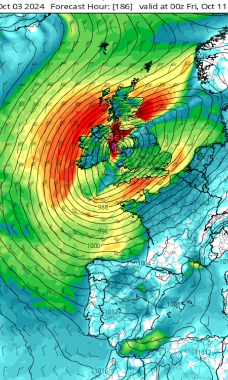
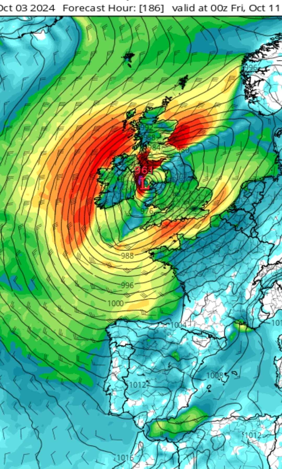
Models actually show Kirk impacting land big time. I'm not really familiar with northern European storm systems... what would this scenario actually look like for the UK/Ireland? Would they experience hurricane conditions and storm surge?
-
2024 Atlantic Hurricane Season
cptcatz replied to Stormchaserchuck1's topic in Tropical Headquarters
Looking likely that there will be two concurrent major hurricanes (Kirk and the next one right on its heels) in the central Atlantic on the first week of October. Pretty logical to have 5x ACE given that situation this time of year. Let's see what happens with this Gulf system though... -
2024 Atlantic Hurricane Season
cptcatz replied to Stormchaserchuck1's topic in Tropical Headquarters
Will need a few more to surpass 2020 or 2005. For US Gulf Coast landfalls, 2024 is at 4/4/1 (Beryl, Debby, Francine, Helene) 2020 was 8/5/2 2005 was 6/5/4 -
2024 Atlantic Hurricane Season
cptcatz replied to Stormchaserchuck1's topic in Tropical Headquarters
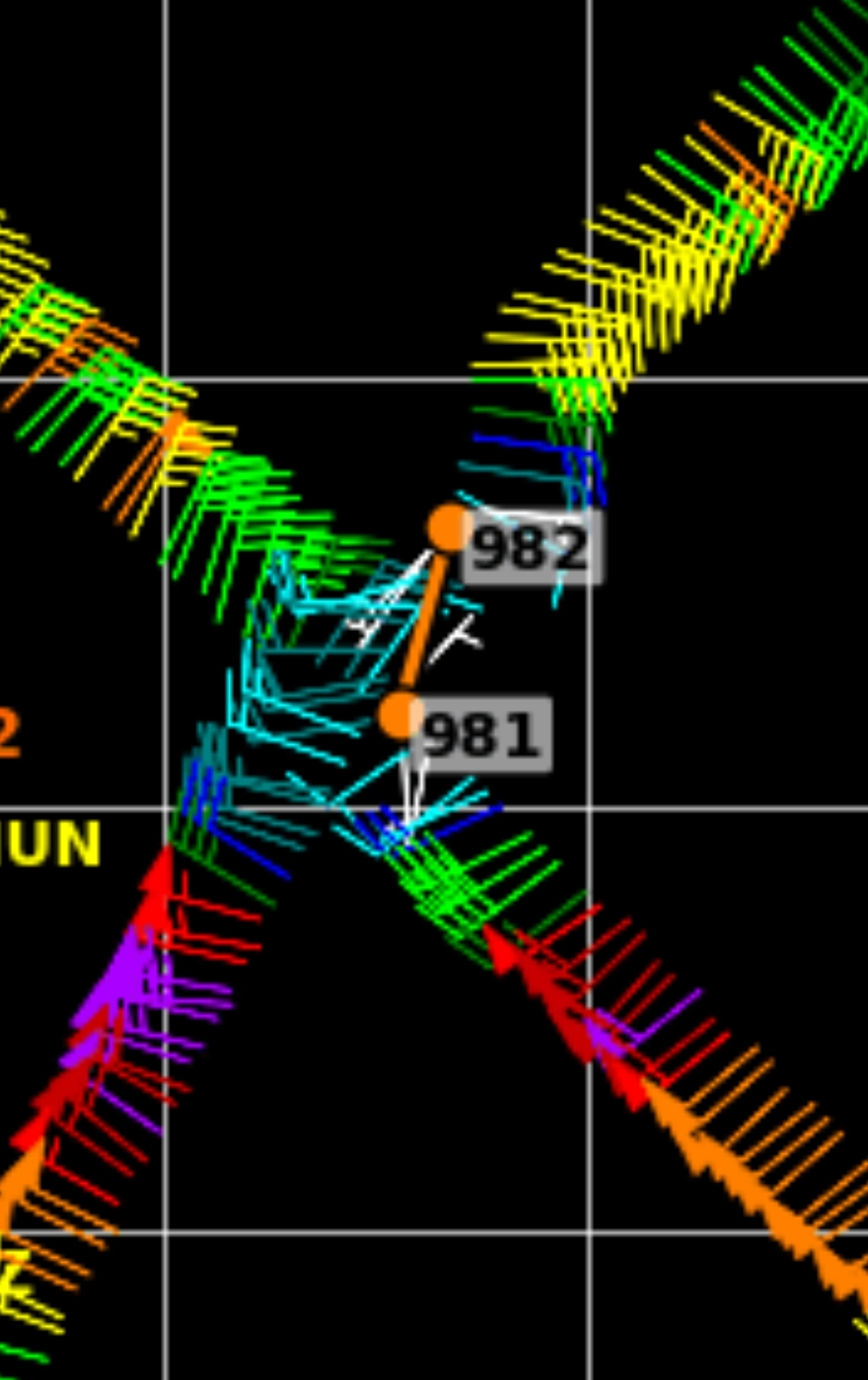
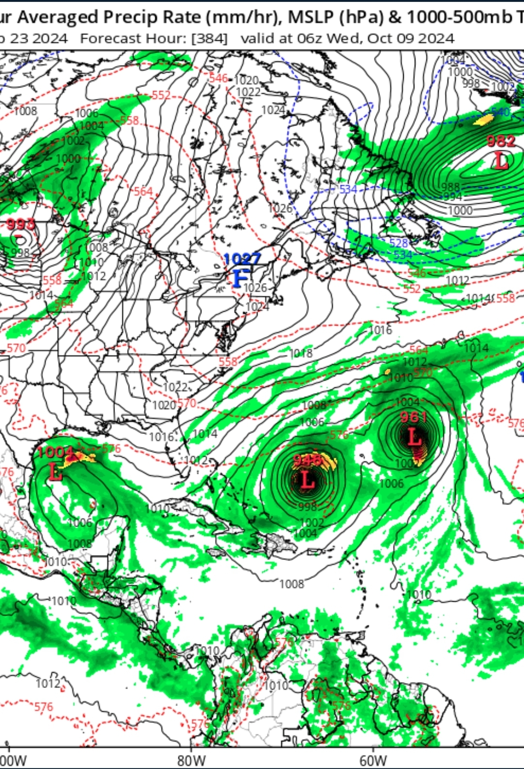
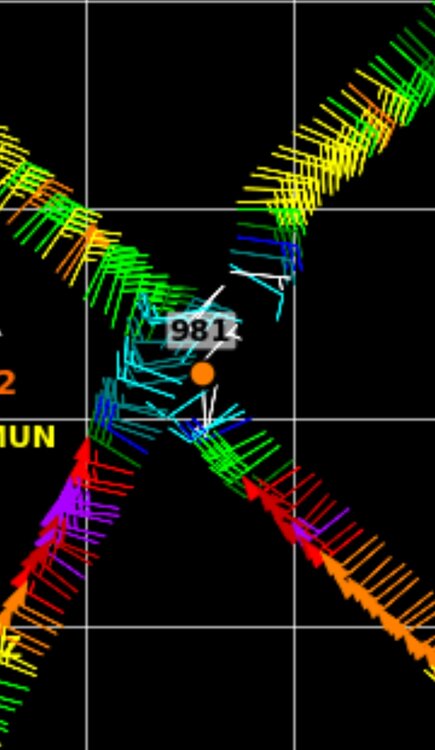
Yep, just did a little case study. Helene mad landfall the night of 9/26 at a pressure of 938 mb. Let's see what the Euro models showed at landfall: 9/21 12z: 991 mb 9/22 00z: 989 mb 9/22 12z: 981 mb 9/23 00z: 982 mb 9/23 12z: 983 mb 9/24 00z: 984 mb 9/24 12z: 978 mb 9/25 00z: 959 mb Euro really didn't catch on to this being a strong hurricane until the day before it made landfall. The fact that the super bearish Euro model is showing a 998 mb storm in the Gulf 9 days out right now should definitely tell you to keep your eye on this one. Especially with GFS showing the same system at 958 mb. -
2024 Atlantic Hurricane Season
cptcatz replied to Stormchaserchuck1's topic in Tropical Headquarters
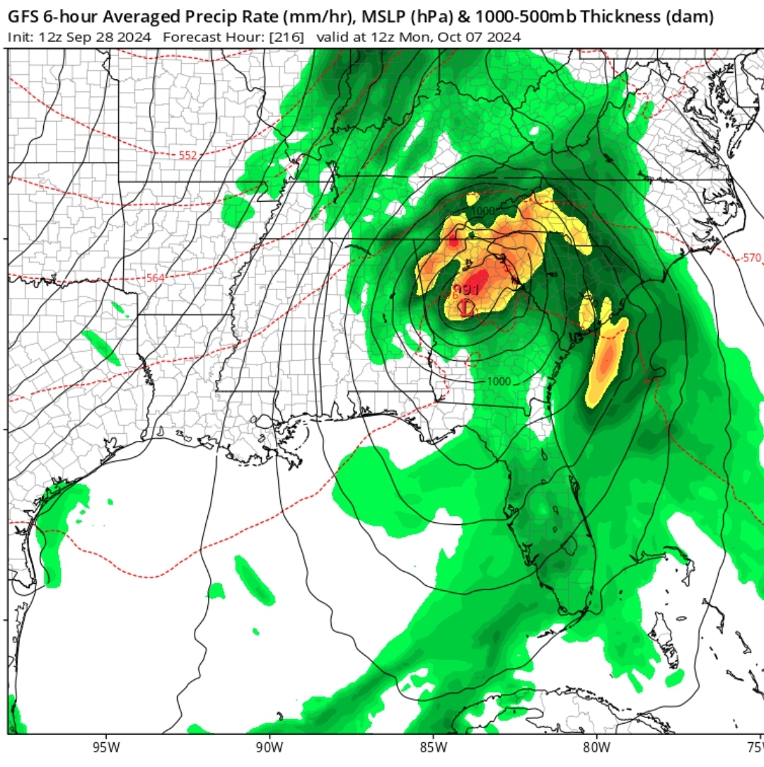
12z GFS not only brings a 958 mb hurricane into the Gulf coast, but probably even more devastating is that it brings the peak rain into the western Carolinas. Shows a tropical storm forming in only 72 hours from now, as well as another monster major fish storm in the central Atlantic.
-
I believe Andy Hazelton was on that flight. If so, he's a big tweeter so we should get a nice recap of what it was like.
-
Those winds die down REAL quick on the west side...
.thumb.png.87572a07deb6aa516d9a570038c11052.png)
-
Assuming the plane that's about to get there took off with a full tank of gas there's no reason to believe it will need to land before landfall.
-
I'm gonna get weenied here but satellite looks like it's making a significant northeast motion and making a bee line into the penninsula. I'm calling landfall around Cedar Key. If it doesn't turn more north, the surge in Tampa could be even worse than thought.
-
And there it is. Is this the real turn to the northeast happening? Would be significantly earlier than models showed...

-
Interested to see where they mark the center from this last pass but from eyeballing the barbs, it looks like it's western movement has ended. Looks possibly a tad east of due north.
-
The name lists are rotated every 6 years. Every name this year also occurred in those years except for ones that replaced retired names.
-
2024 Atlantic Hurricane Season
cptcatz replied to Stormchaserchuck1's topic in Tropical Headquarters
Might be getting ahead of myself here but after Helene, it looks like the next threat may be the MDR storm which will come off Africa this weekend. There's a strong signal across all models for a low rider that looks like could make it to the caribbean and could be strong. Euro here: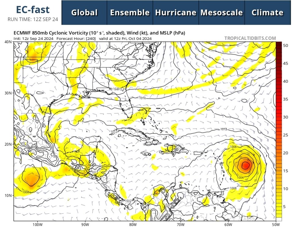
-
Impressive amount of convection popping now off the Yucatan coast. Seems the sheer is gone. Should wrap up now.
-
Last few frames of visible satelite make it look like that naked swirl is moving almost due south.
-
2024 Atlantic Hurricane Season
cptcatz replied to Stormchaserchuck1's topic in Tropical Headquarters
Hour 384 of this morning's GFS make October 9 look more like September 9. MDR season is definitely not over yet.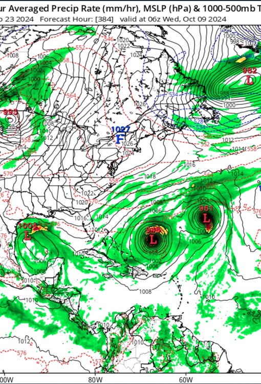
-
Not seeing that. 06z has two members anywhere on the west coast of florida. All others are big bend and west.
-
8am up to 10/70 and we now have an X on the map. Hopefully that means in invest is coming later today.
-
18z GFS coming in hot. 951 mb headed towards the Panhandle at h126
-
Also tornado threat with these big broad tropical storms moving into the gulf coast.
-
2024 Atlantic Hurricane Season
cptcatz replied to Stormchaserchuck1's topic in Tropical Headquarters
Looking ahead, the long range GFS is finally showing big action with 4 hurricanes in the next 15 days. It does seem that this season will just be back loaded. -
2024 Atlantic Hurricane Season
cptcatz replied to Stormchaserchuck1's topic in Tropical Headquarters
Wild GFS run with that MDR storm making it's way into the caribbean as well... -
2024 Atlantic Hurricane Season
cptcatz replied to Stormchaserchuck1's topic in Tropical Headquarters
Watch out with that next MDR storm. I'm actually surprised the NHC hasn't marked it yet, models are showing TCG taking place in the eastern Atlantic at a very similar time as the caribbean. The caribbean storm could very well be the dreaded I storm if it takes its time to organize... -
2024 Atlantic Hurricane Season
cptcatz replied to Stormchaserchuck1's topic in Tropical Headquarters
Interesting thing to note is how big the models are showing this storm being. Remember that storm surge isn't about the max winds of the eye wall but the size of the storm and the time over water are far more impactful. This set up could result in historic storm surge.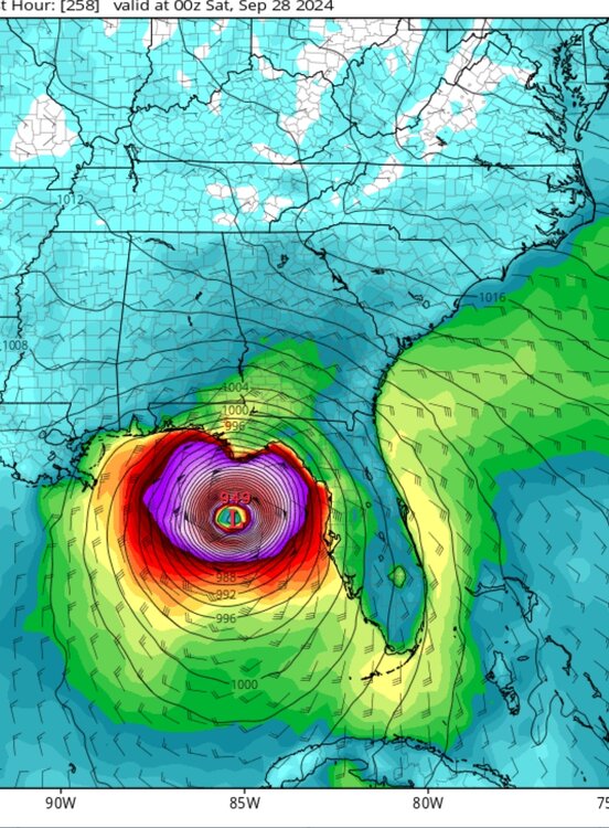
-
2024 Atlantic Hurricane Season
cptcatz replied to Stormchaserchuck1's topic in Tropical Headquarters
GFS now with 4 runs in a row with a major hurricane in the Gulf/Florida Straits. That 0z run demolishes the entire east coast. GFS and CMC now in good agreement, just need to see if Euro comes in board or not.


.png.f3adb44acde729a76d734d324656e468.png)