fluoronium
-
Posts
219 -
Joined
-
Last visited
Content Type
Profiles
Blogs
Forums
American Weather
Media Demo
Store
Gallery
Everything posted by fluoronium
-
It's beautiful outside now. Most of my best storms in recent years have started with anomalously warm temps the day before the main event. HRRR is suggesting some heavy banding further west in central IL. Peoria area posters would like this scenario.
-
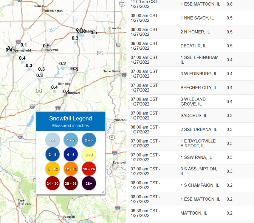
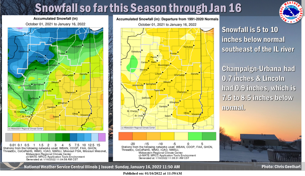
This is quite a change compared to such an abysmal start to winter in eastern IL. Has Champaign even received a 1" snowfall yet this season?
-
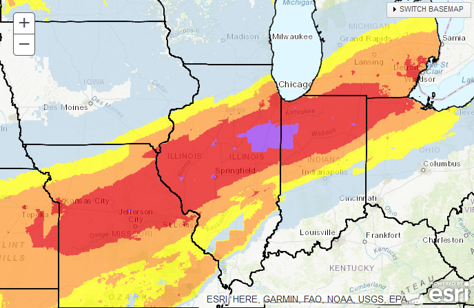
Decent sized area of "extreme" shown on the winter storm severity index forecast.
-
What are the chances of lightning in the the heaviest bands here? I've seen thundersnow from intense fgen bands before but I really don't know what to look for on the models to have an idea of this possibility. From my understanding, slantwise instability isn't apparent from simply looking at skew-T diagrams, and there's probably more to it than just a sharp horizontal temperature gradient. I'd love to hear input from some of the more knowledgeable members here.
-
It actually wasn't. That 36" in 24 hour snow total was in Astoria, IL in 1900. There must have been some tight banding with that system, since Peoria only received half of that. https://www.ncdc.noaa.gov/extremes/scec/records
-
Bonkers seeing ensemble mean totals like that. The operational 18z GFS is nearly an all time weenie run for my backyard. It would be incredible to have such a garbage season drop a monster storm of even half of what was is modeled there. I know it has happened to Chicago in recent years, but I've missed out on most of the fun in recent Februarys.
-
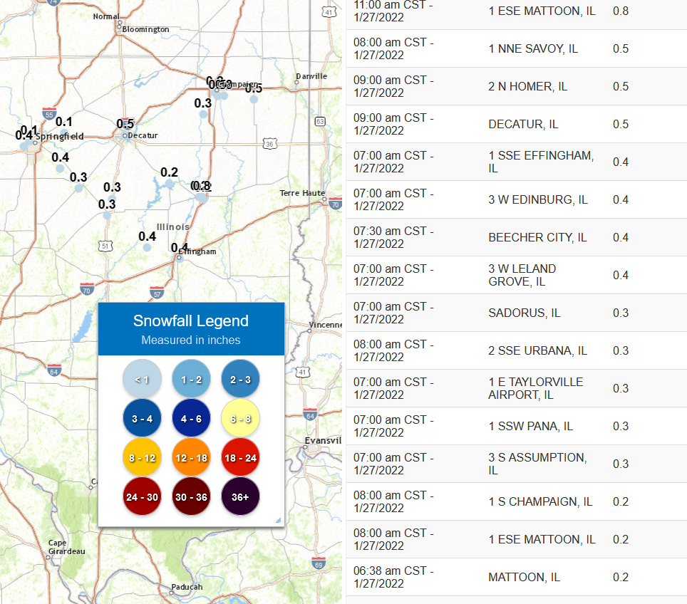
Crazy things happening in east central IL this morning, with multiple locations already reporting the biggest snow of the season. Effingham's accumulation is roughly infinity times larger than their entire season to date snowfall.
-
Wind chill advisory and a bare ground. Rough times here in central IL.
-
Not a good look going into an extended period of cold and dry.
-
Winter 2021-22 Short/Medium Range Discussion
fluoronium replied to Chicago Storm's topic in Lakes/Ohio Valley
I lost all of my rhododendrons and a lot of other plants rated for zone 4 in that cold snap, and I'm in zone 5b. Now I welcome these sudden cold snaps, since they are good for beating down invasive insect populations like Japanese beetles and emerald ash borer. Plus, what plants I had survive that snap should be able to tolerate future extreme cold here. -
December 15th-16th Warmth, Wind, and Severe Threat
fluoronium replied to Geoboy645's topic in Lakes/Ohio Valley
Oh here's a scary/cool video from this outbreak: -
December 15th-16th Warmth, Wind, and Severe Threat
fluoronium replied to Geoboy645's topic in Lakes/Ohio Valley
I have no idea what he was thinking, since models had been consistent on an outbreak setup for at least a week prior to that. I mean just the anomalous warmth in December alone is a pretty solid bet for at least some severe weather. In Broyles defense, he did call the 3/28/20 crapvection bust 4 days out, and he was also the mastermind behind this amazing resource for violent tornadoes: https://www.spc.noaa.gov/exper/outbreaks/outbreaks-small.php# -
December 15th-16th Warmth, Wind, and Severe Threat
fluoronium replied to Geoboy645's topic in Lakes/Ohio Valley
I'm glad I saved a copy of this gem. We can't let the SPC cover up this one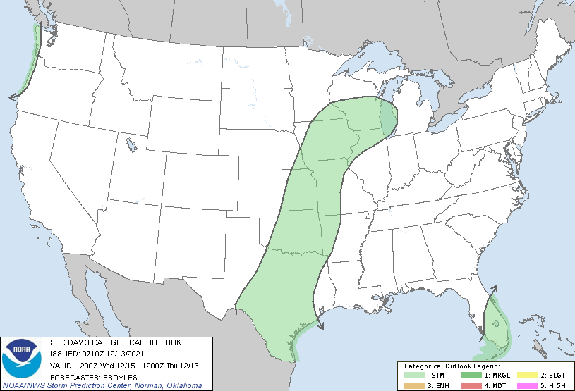
-
I've been sitting right at the cutoff most of the day, getting a mix of sleet and snow accumulating to about 2". For such dense ratios, the snow is surprisingly dry and not sticking to the trees much. Funny how winter is finally starting here on January 1st, just like last year.
-
POLL: 2021-2022 Season Snowfall Total @ ORD
fluoronium replied to cyclone77's topic in Lakes/Ohio Valley
40"+ or bust -
Winter 2021-22 Short/Medium Range Discussion
fluoronium replied to Chicago Storm's topic in Lakes/Ohio Valley
Stop poking it!!!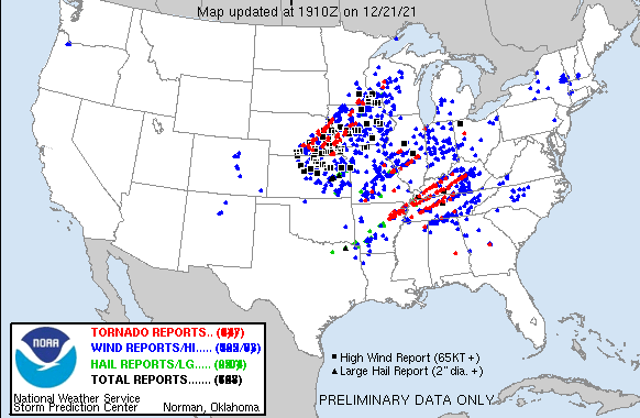
-
December 15th-16th Warmth, Wind, and Severe Threat
fluoronium replied to Geoboy645's topic in Lakes/Ohio Valley
Any amount of severe weather in that region would be historic for the time of year, so this has the potential to be absolutely insane. It's too bad storms are going to be mainly at night and moving at incredibly fast speeds. -
It's a crazy we have a threat like this so close to the shortest day of the year, but then again, cold season has been the severe season in my area in recent years. It's a shame initiation will likely be after sunset, but regardless I'll be chasing anyway due to the rarity of the event. This is actually quite a scary setup considering the giant area of the warm sector, the screaming storm motions, and nighttime initiation. Plus many will be caught off guard due to the fact that it's December. Even crazier is that we might get another tornado threat next week much further to the NW.
-
There's still a consistent signal for severe in the southern portions of this subforum for the 10th. I'd be happy without seeing a single flake of snow this month if it meant I got to see an elusive December tornado.
-
At this point I've conceded that December is merely an extra month of fall. If it's not going to snow, torch it. Maybe we can squeeze out some cold season severe with that SE ridge that keeps showing up on the models.
-
I've never seen a tornado in anything above a SPC 5% tornado risk
-
A nice thing about chasing a setup like this is that even if all the supercells crap out, you'll still get treated to a nice MCS at the end of the chase. Point your car into the wind and enjoy
-
I'd be more interested in future supercells that develop along/south of that boundary. If I was closer I'd be chasing it.
-
I can't believe there's no flash flood watch out in central IL for this rain band of death
-
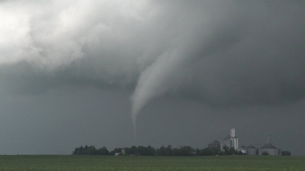
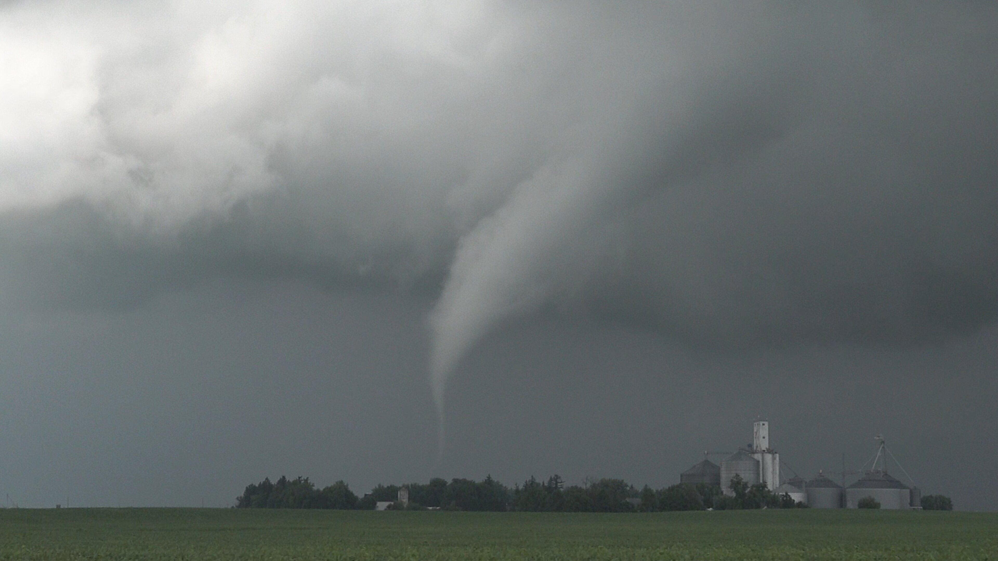
I'm still feeling the afterglow from my August 9th chase. All time best chase for me! So many tornadoes with beautiful, textbook structure!! It's been a brutal couple of years for storm chasing locally so it is so nice to have a day perform like that.