JakkelWx
-
Posts
3,337 -
Joined
-
Last visited
Content Type
Profiles
Blogs
Forums
American Weather
Media Demo
Store
Gallery
Everything posted by JakkelWx
-
33ar does have some cutthroat subs though. They have this one thread called "index to papers and presentations" and I dind it very nteresting.
-
Who's Jakkel138? He seems like a really great guy. At least it got 8 reactions!
-
Yeah their rule has a few flaws. But RIP my inbox
-
GEFS looks very nice for the December 22 threat. Unfortunately I won't be posting maps anymore because the information I get is from 33andrain. Can't be ripping maps from that forum man! Here is the reminder, in case anyone hasn't read it yet: By the way, I DO admit to taking screenshotting content from 33andrain in the past. I am 100% guilty of doing this.

-
I have a feeling snowboy19 is a clone of Dr Dewche
-
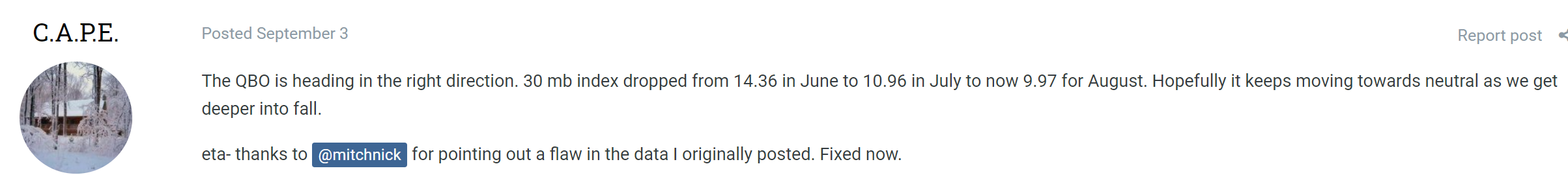
Does anyone have the latest QBO data? I'm not so sure where to look. Any websites? @C.A.P.E. So far the QBO has been one of the factors has or is going to work in our favor moving forward. Now that it's December and the QBO is in a favorable spot and has granted CAPE's wishes so far, hopefully it stays between -5 and +5 throughout the winter.

-
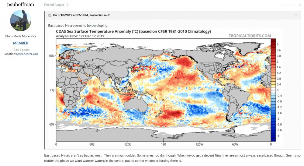
A follow up on my post from Aug. 10 from the "Is next winter looking like a disaster" thread: PSU alluded to my post about how east based Nina's are better than west. While I do see that the east based cooling has somewhat expanded westward, I see a Modoki signature in the western central Pacific. ENSO progression to me still doesn't look less favorable than it did in August. Wouldn't mind slightly more warming in the CPAC tho. I see above average water temps in the NAtl near Greenland as well, which indicates a -NAO. Pacific somewhat resembles a victoria mode PDO. One thing I wish I did was save the ENSO anomaly map on that day and put it in one of my file folders for future reference.
-
The 12z EPS is BN from about 12/17 to the end of the run.
-
I still got a snowpack in a shady area behind my house. Will it last into Christmas? Side note: I took some of that snow and put it into my freezer so when Christmas comes I'll spread the hardened snow over the grass so I get a white Christmas.
-
We flash freeze into a tray of ice cubes if that verifies
-
A new New Jersey?
-
GFS is still showing a similar HECS albeit 3 days earlier. Lock it in:
-
What's Delaware?
-
GEFS has a nice blocking signal. Would crush weenie dreams if this didn't verify.
-
GFS with the sh*ts and giggles at the end of the run
-
32/31 and 1''
-
Didn't expect to wake up to about an inch of snow OTG this morning, eyeballing it. I was expecting a dusting at most when I woke up, which I usually do three quarters before 6 AM Edit: Unfortunately it's ending earlier than I expected though.
-
Down to 47/45 here. DP dropping like a rock as well as temperature while it's raining. Mesoscale analysis shows an 8 degree temp drop over C MD last 3 hours.
-
Has a strong scand ridge forming around D9 and remains in place to the end of the run. Can see it feeding the -NAO in the NAO region. GEFS also supports the OP with a scand ridge forming around the same timeframe as the HH GFS. Edit: Ninja'd by Bob
-
Just had a burst of wind and a 3 degree temp drop. Down to 49 now.
-
Hint?
-
52 here. I think you might see a changeover before I do.
-
Lock it in!
-
Or a potential MECS if the canadian high trends stronger and we time it just right with the TPV staying back.
-
But judah said mild winter coming because the pv will fail to split!