JakkelWx
-
Posts
3,337 -
Joined
-
Last visited
Content Type
Profiles
Blogs
Forums
American Weather
Media Demo
Store
Gallery
Everything posted by JakkelWx
-
I will gladly shovel some rain off my driveway and place it in your rain guage.
-
Holy the newest NAM 15z run is MUCH colder and shows snowfall rates of over 10 inches an hour
-
PSU getting fringed summer style?
-
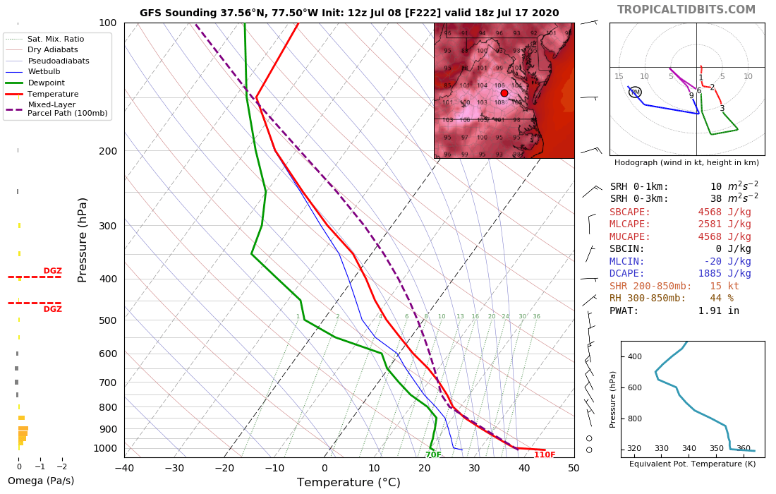
RIC 110F in under 10 days?

-
12z GFS is an absolute torch over the central and eastern U.S starting around the end of next week
-
Only a matter of time before there's a semi permanent Ridiculously Resilient Ridge (RRR) over the U.S during every summer.
-
The SPC needs to brush up on their drawing skills
-
I researched it a little and turns out its a "wake low" which sometimes forms typically on the northern edge of a MCS squall line. I don't think it's an artifact.
-
Some sort of mesolow right over central DE which appears to be spinning on radar.
-
Can't imagine how hot next summer's gonna be with the 11 year solar cycle thing and what not.
-
I hope we get some T&L this weekend from the late week system.
-
This thing appears to be heading straight towards me. Gonna get in a shelter just in case
-
The National Weather Service in Mount Holly NJ has issued a * Tornado Warning for... Northeastern Queen Anne`s County in northeastern Maryland... North central Caroline County in eastern Maryland... Central Kent County in northeastern Maryland... * Until 800 PM EDT. * At 722 PM EDT, a severe thunderstorm capable of producing a tornado was located near Old Town, or 8 miles north of Centerville, moving southeast at 30 mph. HAZARD...Tornado and quarter size hail. SOURCE...Radar indicated rotation. IMPACT...Flying debris will be dangerous to those caught without shelter. Mobile homes will be damaged or destroyed. Damage to roofs, windows, and vehicles will occur. Tree damage is likely.
-
Very cold cloud tops on IR
-
Me and @C.A.P.E.
-
We are about to get rocked.
-
All that this OFB is doing so far is producing broken up clouds that never make it to storm status and just fall apart.
-
Looks like there may be 2 main areas of development: DC - SEPA, and the eastern shore into Delaware as there's two OFBs about to collide over the DE Bay as mentioned earlier.
-
Radar showing 2 outflow boundaries heading towards each other over the DE bay.
-
Hardly a CU field at all here as well, meh.
-
Flooding rescues happening in Philly currently
-
July 2020 General Discussions & Observations Thread
JakkelWx replied to Rtd208's topic in New York City Metro
Plenty of lightning with that cell. Insane. -
Craven/Brooks SigSvr up to 40 in SEPA with 30+ all around the area along with a wide expanse of 4,500 J/kg SBCAPE/3000-3500 MLCAPE and DCAPE values 900-1100.
-
No FFW here, probably because of abnormally dry conditions raising FFG