
brianc33710
-
Posts
281 -
Joined
-
Last visited
Content Type
Profiles
Blogs
Forums
American Weather
Media Demo
Store
Gallery
Everything posted by brianc33710
-

Mid to Long Range Discussion ~ 2024
brianc33710 replied to buckeyefan1's topic in Southeastern States
This has accumulated snow all the way down to Tampa Bay! -
Mid to Long Range Discussion ~ 2024
brianc33710 replied to buckeyefan1's topic in Southeastern States
One model now even has a changeover to snow on Monday across N AL due to the incoming cold. ABC 3340 showed that at 1115 am. -
Mid to Long Range Discussion ~ 2024
brianc33710 replied to buckeyefan1's topic in Southeastern States
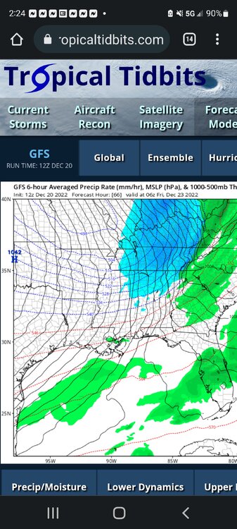
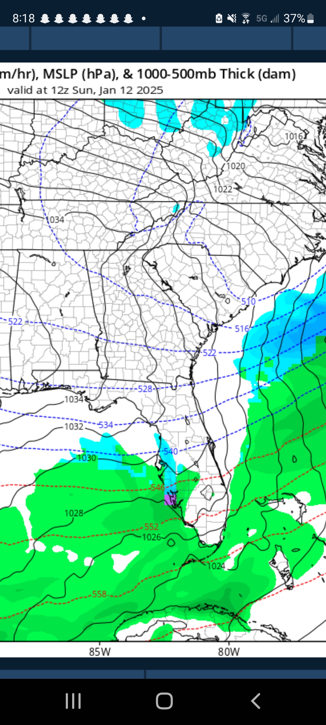
GFS actually showed some snow not just in Tampa but down to Ft. Myers lol on 12 Jan. I took a screenshot b/c I knew this is something I wouldn't see many times in my life lol.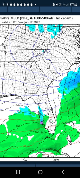
-
Yeah I noticed that too.
-
The local NWS offices issue "Extreme Wind Warnings" for along where the eyewall comes ashore. But the SPC & the NHC separate hurricane winds with severe storm winds. Local NWS offices do as well. They issue Tropical Storm & Hurricane Warnings to address high wind events from Tropical systems. They'll issue tornado warnings but not severe thunderstorm warnings.
-
But last night the winds were 175-180 at these pressures. That's why I'm asking. Especially when he fell from 905 to 902. Thank you @DDweatherman!
-
OK officially 902 mb. So why haven't the winds fallen with the pressure tonight? Monday Milton had higher winds & pressures than now. And I sincerely apologize for the wrong info earlier.
-
That's what I was thinking! I figured Milton had finished the EWRC.
-
3rd, behind #1 Wilma & #2 Felix. @DDweatherman I tend to think Milton makes 1 more run for 185 mph & sub 900 mb pressure, given the almost perfect intensification conditiconditions he has Tuesday in the loop with no shear. As a bigger & stronger storm, winding down from shear & dry air may take longer. I think 135, a low end Cat 4, is the landfall windspeed, not 125.
-
Lutz is north of town though.
-
May 16 - June 4, 2024 Severe Weather
brianc33710 replied to Quincy's topic in Central/Western States
The SPC Almost issued a day 2 High Risk. This looks serious. @Quincy Wichita appears to be in the bullseye tonight riskwise at least. They are in 15% hatched tornado, 45% hatched wind & 30% hatched hail--the max SPC has assigned--even if Wichita isn't in the middle of the MOD Risk. Overnight/early am we'll probably see a High Risk somewhere in the MOD. -
May 16 - June 4, 2024 Severe Weather
brianc33710 replied to Quincy's topic in Central/Western States
Day Two Moderate Storm Prediction Center May 20, 2024 1730 UTC Day 2 Convective Outlook (noaa.gov) -
May 16 - June 4, 2024 Severe Weather
brianc33710 replied to Quincy's topic in Central/Western States
95/90 wind & 95/80 hail, SPC warned for 75-100 mph winds when they raised to MOD. @Gobucks15 That’s what the SPC fears is happening & why they went with a rare PDS Severe Thunderstorm Watch. -
PDS Severe Tstm Watch in Cen MS. Storm Prediction Center PDS Severe Thunderstorm Watch 293 (noaa.gov)
-
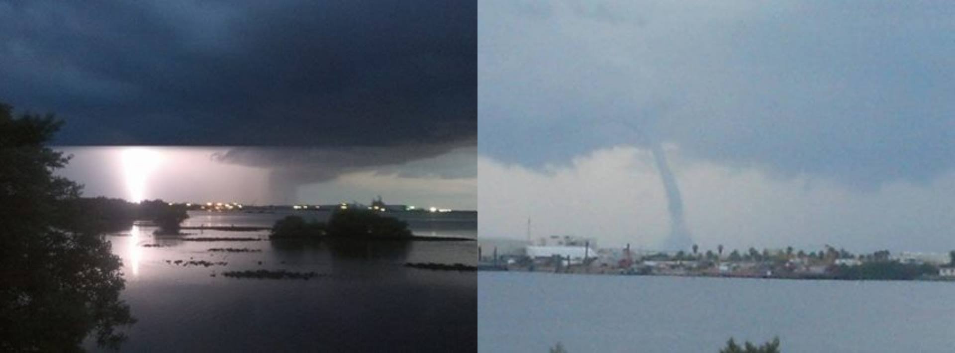
Well successfully tracking down a tornado that's just a little shit is better than no tornadoes at all lol. I remember 2013 when my apartment overlooked Tampa Bay I got a bunch of great waterspout pictures & videos. But my ex apparently deleted all of them from my Facebook without my permission (& a ton more). I only have 1 background picture that's 1/2 lightning strike & 1/2 waterspout left.
-
AL was spared a fairly significant severe weather outbreak a few weeks back due to this warm capping. Most of the other ingredients were there for a notable event. Will this hold through the night? A strong storm headed toward San Antonio died before getting there.
-
So for Day 1 do we have 2 MODS, 1 big MOD, 1 HIGH & 1 MOD, or 2 HIGHS? I'll go with 2 MODS but will fully admit I thought the SPC HIGHS were an overreaction Friday. I wish I had been right.
-
The tiniest possible corner of NW AL is in the 2/5 now. Literally, if there's a house on the AL/MS/TN front yard is Slight & the house & back yard are Marginal lol.
-
Concerns me that the potential for a more extensive & violent outbreak has returned. I apologize for not making that more clear.
-
The SPC didn't mention the possible inhibiting factors they mentioned in previous update. That concerns me.
-
I remember at least 2 2022 severe weather events in AL that were expected to be fairly extensive, 3(E)-4(W)/5 threats. The models showed a warm & humid influx of air from the Gulf. While the warm air mass arrived the humidity didn't. We had 80s/30C temps with >50 mph/80 kmph wind gusts but dewpoints held in the low 50s/10s in Bham & not much higher in Tuscaloosa which is almost always more humid than Bham. Usually the baseline dewpoints here for severe weather weather is 55F/12.5C. As a result we actually had a number of wildfires because of downed powerlines in advance of the delayed rain. But instead of a tornado outbreak we had less severe straight line winds. The dewpoints finally reached 60F/15.5C when the rain arrived but not before.
-
IF you look at the "max" in the bottom right corner it's 25.47. Look closely cause it's not on the picture itself. I just messaged you too. Please read it when you get a chance.
-
Check out some of these STPs. I thought the max was 20! https://twitter.com/realStarInBox/status/1642715078809067521/photo/1 OK so this may or may not work..... EDIT The link opens. I just couldn't share the photo itself. EDIT 2: I had shared a hodograph using the above given STPs but didn't want to use someone else's work from another forum. So I deleted the follow up message.
-
Historic Christmas Cold & maybe snow?! Dec 23rd-30th
brianc33710 replied to Wurbus's topic in Tennessee Valley
I saw Spann got caught off guard tonight when the model showed a 6F/-14.5C for Bham in this outbreak. This must be what you found. He felt the reading was too low. I'm still sticking with 7F/-14C as Bham lowest, which would match Jans '03 & '14. -
The GFS shows some snow for Friday. Given the severity & speed of the air mass I find it impossible to believe we wont at least briefly switch to sleet &/or snow. The GFS has Bham at 7F/-14C & Euro has 9F/-13C.