largetornado
-
Posts
137 -
Joined
-
Last visited
Content Type
Profiles
Blogs
Forums
American Weather
Media Demo
Store
Gallery
Everything posted by largetornado
-
The blatant disregard for life and property in this thread is appalling.
-
Is it possibly the start of an eyewall replacement cycle?
-
160k without power in Cincinnati.
-
I ended up on 64 in shelby county kentucky. Pretty sure i was in a circulation but could not punch in front of the line as the winds were incredibly intense and visibility was all of 5 feet. I finally called it quits after being in it for a solid 30 minutes. Most intense driving ive experienced. One hell of a storm. And FWIW a mesonet station in Shelby county recorded a 75 mph gust
-
The bottom sill plate is missing and broken in places. I also saw another post where an anchor bolt was visible in a CMU foundation but survey noted “no connection.” this survey is bogus.
-
Tim mentioned vehicles on his Facebook. That’s a joke. The average new vehicle is heavier and more aerodynamic than in the past. This is a poor rating
-
I AM NOT DISCOUNTING THE DAMAGE. However, that concrete work was improperly done. They didn’t pull the rebar up and it basically sat at the bottom of the pour (if they pulled it up, no way that concrete breaks like that or there would at least be evidence of the rebar in the concrete). In other words, that rebar provided little if any strength) I’m very curious where the hell that rebar grid went as post tornado pictures just show gravel.
-
Reed timmer posted a video from someone showing it as a wedge on approach to the Mississippi River. He tweeted “likely 1 tornado”
-
8 dead, 8 missing at candle factory. Not 70 dead like early estimates per AP and candle factory spokesman
-
Completely leveled. Insanity
-
I’m kinda curious why the storms aren’t spinning more. Srh of 400+ per mesoanalysis. Not surfaced based storms?
-
Models continue you to trend tomorrow’s system north. Not sure if separate thread is warranted. But latest models have significant sfc-1km srh values extending to i70 and Indiana is covered in UH tracks
-
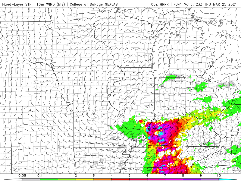
FWIW, it looks as if the threat to the southern half of subforum is growing for Thursday. 06z HRRR popped some significant STP values.
-
2019 Short/Medium Range Severe Weather Thread
largetornado replied to snowlover2's topic in Lakes/Ohio Valley
ILN vwp hodo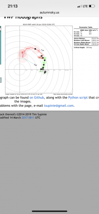
-
2019 Short/Medium Range Severe Weather Thread
largetornado replied to snowlover2's topic in Lakes/Ohio Valley
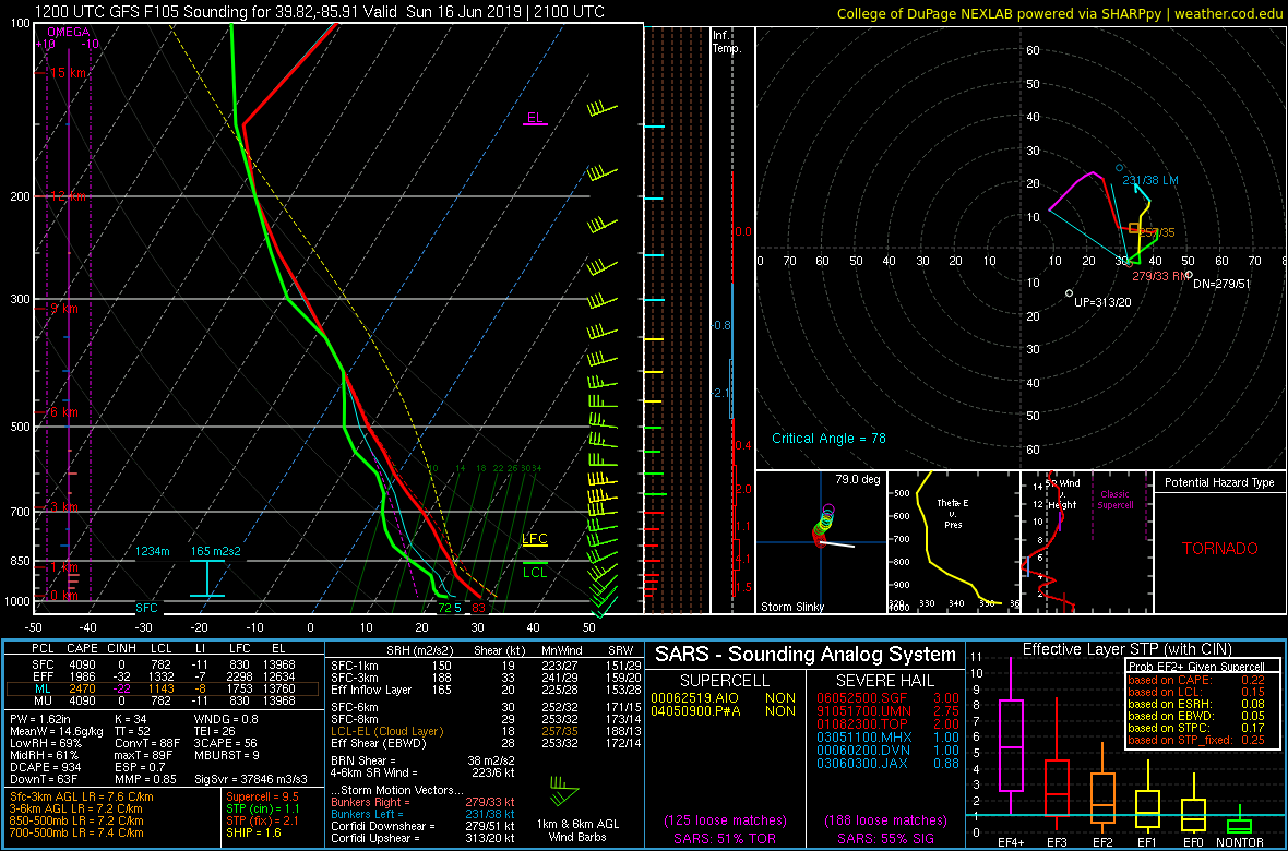
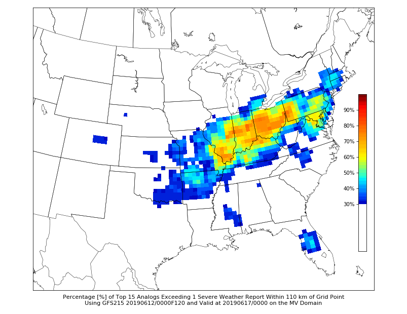
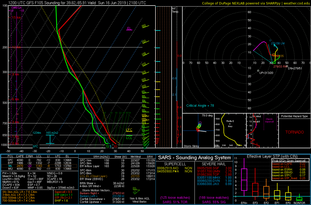
Sunday may be the first of a series of active days across the subforum. Analogs have a few solid tornado events. (6/22/91, 6/6/2010, 6/4/2008) Sounding is from around indy at 21z. Not overly impressed with wind profile. Pretty veered at surface and highish LCL's.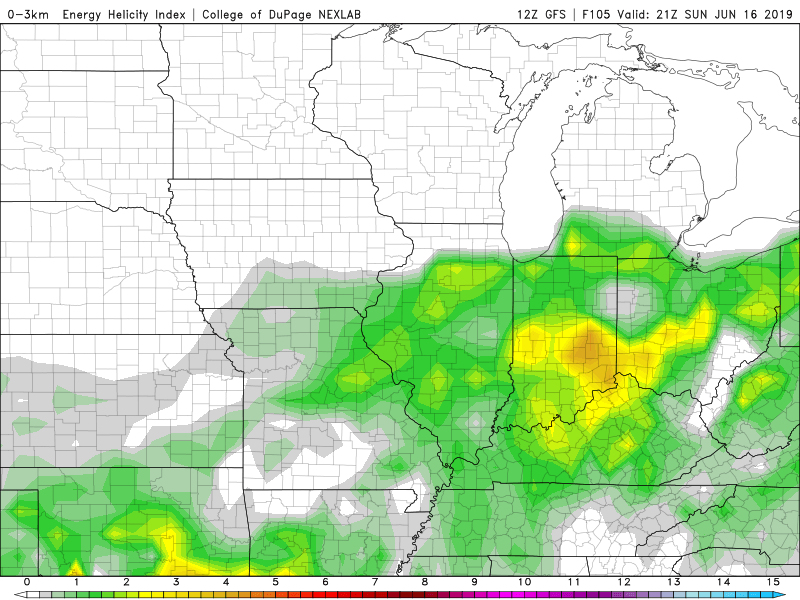
-
2019 Short/Medium Range Severe Weather Thread
largetornado replied to snowlover2's topic in Lakes/Ohio Valley
Couple severe thunderstorm warnings in Kentucky. Surprised that SPC does not have out MD or watch.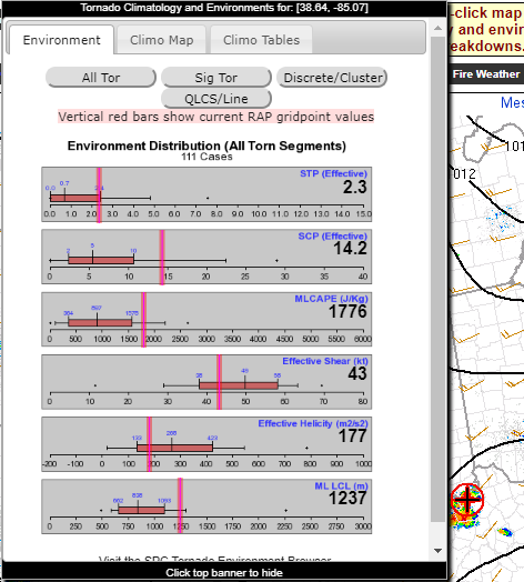
-
2019 Short/Medium Range Severe Weather Thread
largetornado replied to snowlover2's topic in Lakes/Ohio Valley
Indiana has pretty good parameters tomorrow...Might be a late sleeper if stuff can form. -
2019 Short/Medium Range Severe Weather Thread
largetornado replied to snowlover2's topic in Lakes/Ohio Valley
Large part of the subforum under a marginal risk today. ...Ohio Valley/central Appalachians... Widely scattered thunderstorms are possible this afternoon, offering sporadic wind damage, with isolated severe (50+ kt) gusts and marginally severe hail possible. A narrow corridor of favorable return-flow moisture should advect northeastward through the warm sector just ahead of the front, with surface dew points in the mid 50s to low 60s F. This will offset modest midlevel lapse rates to yield a field of 500-1000 J/kg MLCAPE for a few hours this afternoon, with surface-based effective-inflow parcels at least briefly possible as far northeast as western NY. Low-level and deep-tropospheric speed shear should be favorable, though the prefrontal flow will be nearly unidirectional in vertical profile.
-
1777 tornadoes with the first high risk coming on April 23rd in central illinois
-
Central/Western Medium-Long Range Discussion
largetornado replied to andyhb's topic in Central/Western States
CFS disagrees lol -
Central/Western Medium-Long Range Discussion
largetornado replied to andyhb's topic in Central/Western States
Legit question...Will we even see 600 tornadoes this year? At 320ish now. -
Central/Western Medium-Long Range Discussion
largetornado replied to andyhb's topic in Central/Western States
This nugget in the D4-8 outlook.....