largetornado
-
Posts
141 -
Joined
-
Last visited
Content Type
Profiles
Blogs
Forums
American Weather
Media Demo
Store
Gallery
Everything posted by largetornado
-
4/2-4/3 Potential Major Severe WX Outbreak
largetornado replied to Geoboy645's topic in Lakes/Ohio Valley
Latest data does suggest that corridor may be the winner. Im liking between lafayette and indy right now. -
4/2-4/3 Potential Major Severe WX Outbreak
largetornado replied to Geoboy645's topic in Lakes/Ohio Valley
Makes no sense that we get a D2 enhanced when sunday was a D2 enhanced and this is a much more potent setup. Unfortunately, this confuses the public and they will think its the same as sunday which was a relative bust to most people. -
4/2-4/3 Potential Major Severe WX Outbreak
largetornado replied to Geoboy645's topic in Lakes/Ohio Valley
While the severe threat is noteworthy, i feel like the flooding potential for the southern subforum could be catastrophic. 6-10" of rain along the ohio river from missouri to cincinnati. -
Spring 2025 Medium/Long Range Discussion
largetornado replied to Chicago Storm's topic in Lakes/Ohio Valley
Honestly not sure why they issued this. Screenshot is EURO 500 MB for sunday night. GFS has a more pronounced trough but thermos need work. Given that the models are so different at 500 mb, i think this outlook is a bad call. Maybe Little Rock to evansville to bowling green to nashville. There is veering in GFS soundings. I agree there is a risk on sunday, but this large area...i dont see anything that supports it, especially as far north as michigan..png.d81471999d199daa333b73b9dfa9f5ef.png)
-
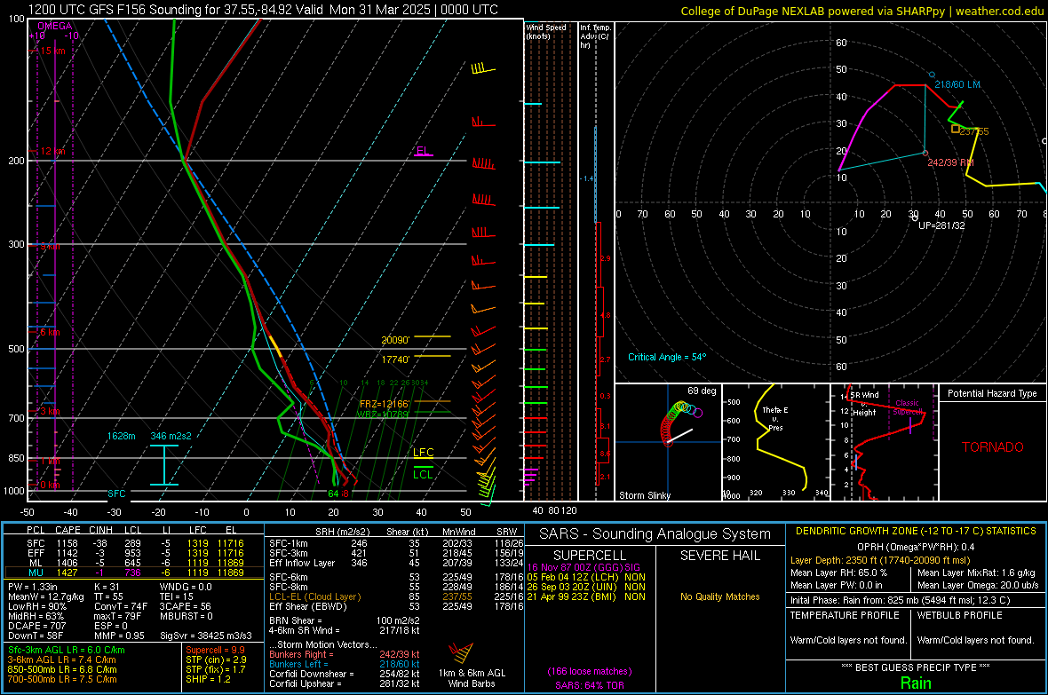
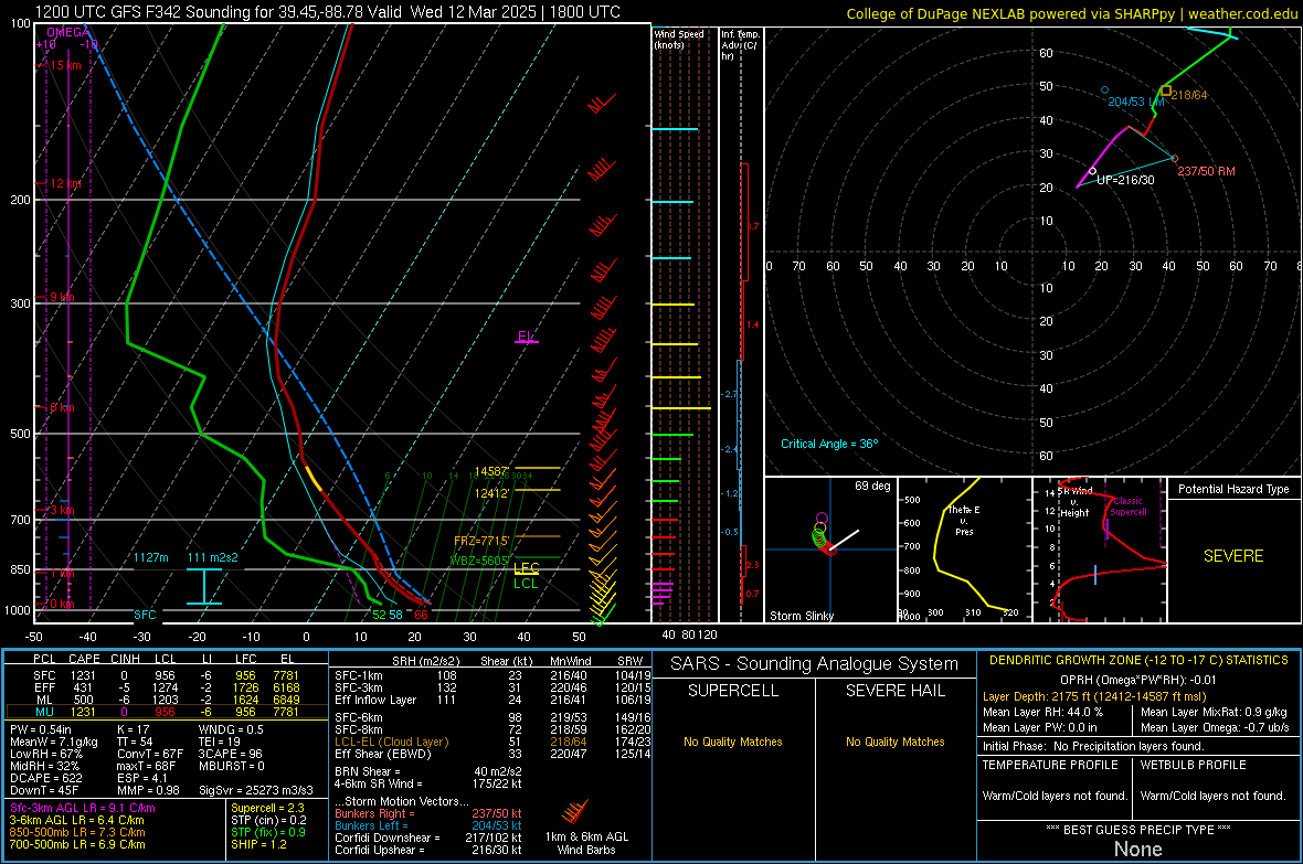
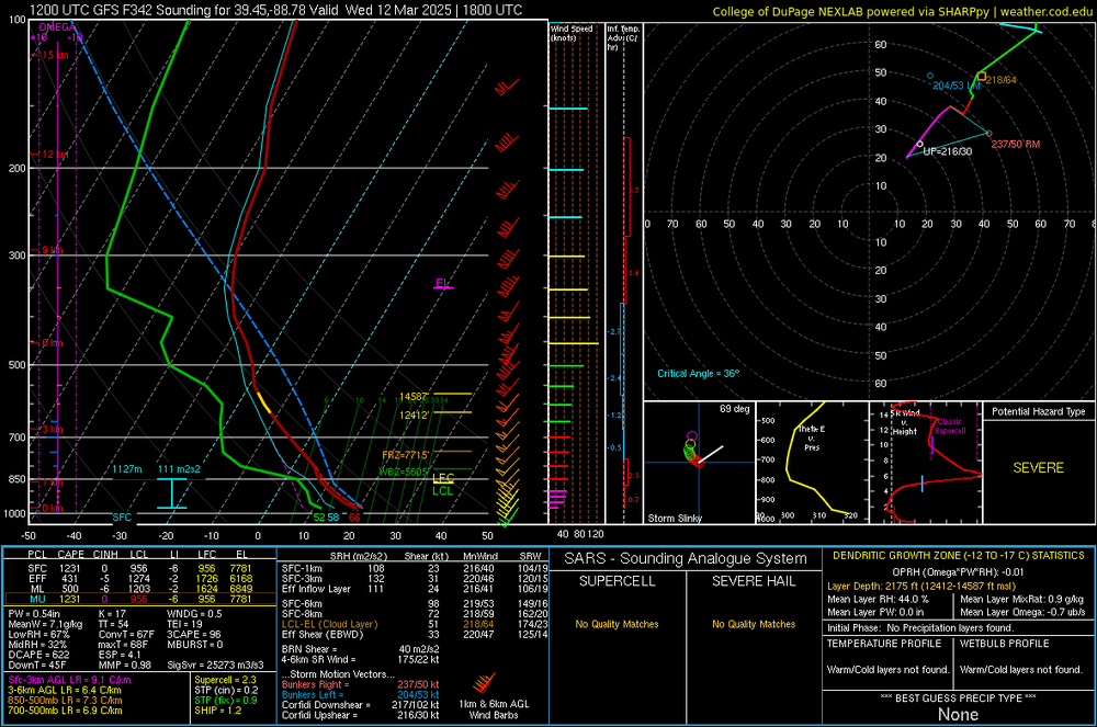
GFS sounding for illinois at 348 hours. not really that note worthy...but the one thing that caught my eye are the lapse rates. sign of things to come?
-
Rumblings of a multi day severe setup around march 4th starting the the plains with a 991 GL cutter the following day. I have a gut feeling we are in for a nasty severe wx season.
-
2/19-2/20 Significant Winter Storm
largetornado replied to largetornado's topic in Lakes/Ohio Valley
-
Southern portion of the subforum is looking at a significant Winter storm tuesday into wednesday. NWS Louisville already has posted winter storm watches for 4+ inches. Models are consistent on a heavy band of 6-10" snow totals along the I71 corridor or just south. I anticipate this will trend a little bit more towards the north but we will see.

-
Had about 9" in cincy. 1/2" of sleet/freezing rain in between two 4-5" layers light and fluffy snow. Without the ice, easily a foot plus storm.
-
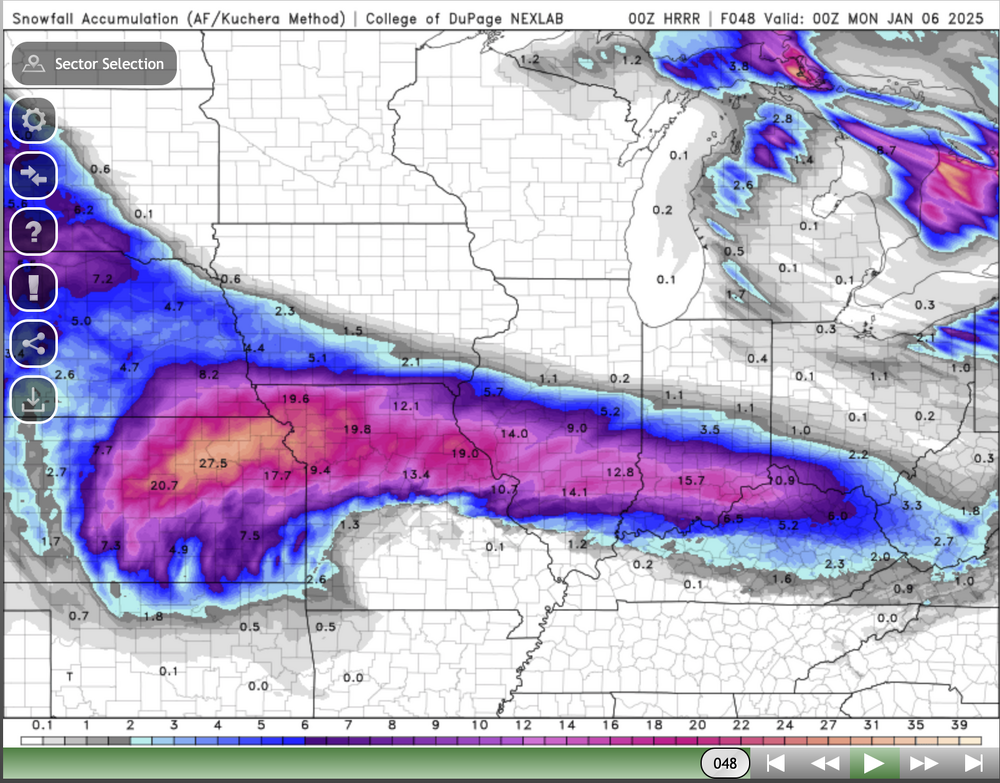
HRRR snow fall. Lol and the storm isnt even over in this run.
-
Can anyone explain why the foreign models (EURO, GPDS, UKMET) have the heaviest snow band south of the ohio river whereas the American models have the heaviest snow band tracking near i70?
-
That hotspot will pull Milton North. $50 says landfall is 2 Miles NW Tampa Bay.
-
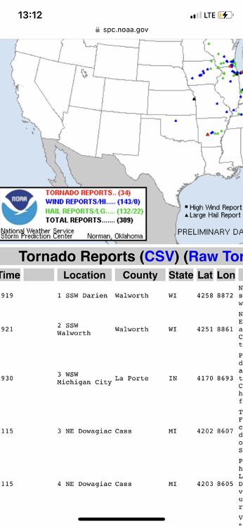
Update to my last post…it was not a storm chaser killed near Corning. Death toll appears to be 4 in greenfield and 1 north of corning
-
Preliminary reports indicating a storm chaser was among the fatalaties

-
Yesterday had more tor reports than Monday
-
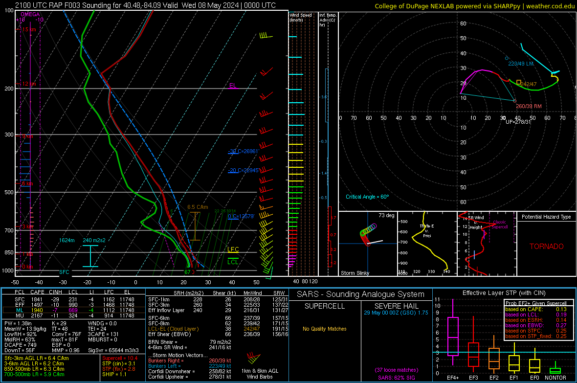
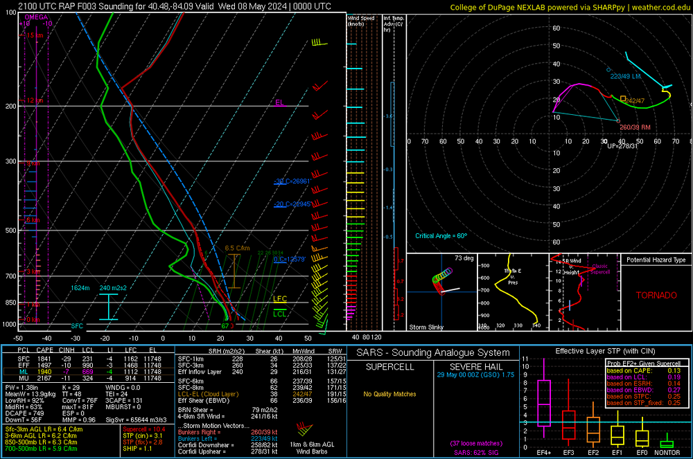
Rap sounding from northwest Ohio. What prevented a mode significant tornado?
-
I really think they need an office for the northern plains, central plains, Midwest, and Dixie. All have those areas have their nuances with tornado forecasting
-
Did damage west of oakwood.
-
The daytime portion definitely busted. The nighttime portion still has time but we will see. Ohio warm fronts are bad news.
-
TDAY is down until further notice. Anyone chasing in that area will be critical to the early warning process as the lowest WSD88 beam is 5-7k ft in parts of Ohio.
-
Slight risk for D2. Little surprising
-
well thats a concerning development. NAM is starting to show a secondary low over illinois.
-
I definitely got ahead of myself. Runs today have significantly downtrended the northern end of the threat.
-
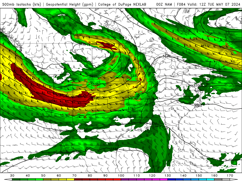
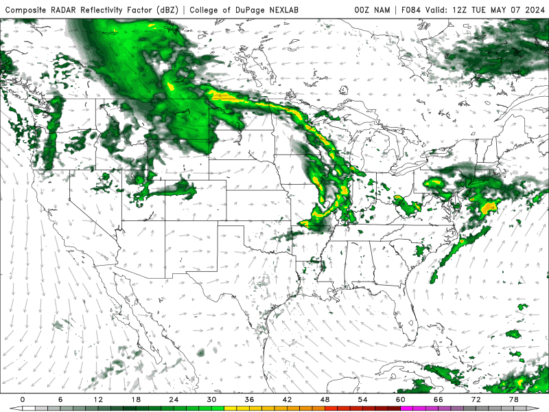
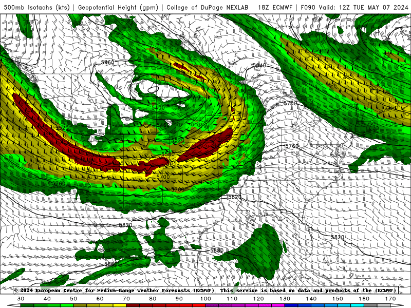
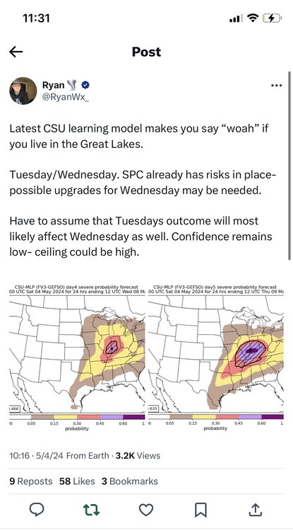
https://x.com/ryanwx_/status/1786761871485219061?s=46 Tuesday and Wednesday continue to look impressive With a decent EML advecting in, morning convection shouldn’t really pose that much of an issue. Per the nam, fairly discrete storms could be expected
-
Tuesday is now coming into range of the nam. Looks like a stout MCS forms in the evening on Monday and rapidly moves east. Based on trends, I expect illinois to be rain free by 15z Tuesday. Also seems like a faster solution is more likely pushing the threat further east on Tuesday. 18z euro is a little bit more amplified and a little slower.