digital snow
-
Posts
144 -
Joined
-
Last visited
About digital snow

-
The “I bring the mojo” Jan 30-Feb 1 potential winter storm
digital snow replied to lilj4425's topic in Southeastern States
Raleigh is getting snow from this. Trust -
The “I bring the mojo” Jan 30-Feb 1 potential winter storm
digital snow replied to lilj4425's topic in Southeastern States
pouring snow and wind whipping near downtown Durham. Closing in on an inch -
January 30th- Feb 1st ULL and coastal storm obs
digital snow replied to JoshM's topic in Southeastern States
Not a flake here. I heard that folks in wnc had their vacuums out last night and sucked up my snowstorm. -
The “I bring the mojo” Jan 30-Feb 1 potential winter storm
digital snow replied to lilj4425's topic in Southeastern States
I don't think someone has to get screwed here. More interaction and a low closer to the coast should backfill nicely. Maybe on the NW side of the low, wherever that ends up?? -
The “I bring the mojo” Jan 30-Feb 1 potential winter storm
digital snow replied to lilj4425's topic in Southeastern States
This one -
The “I bring the mojo” Jan 30-Feb 1 potential winter storm
digital snow replied to lilj4425's topic in Southeastern States
no warnings yet... will someone get a blizzard warning? Never officially happened here. Not out of the question for down east. -
The “I bring the mojo” Jan 30-Feb 1 potential winter storm
digital snow replied to lilj4425's topic in Southeastern States
Getting spicy!
-
The “I bring the mojo” Jan 30-Feb 1 potential winter storm
digital snow replied to lilj4425's topic in Southeastern States
Doom and gloom on this board over a possible epic storm. You guys like snow, right? We are chasing snow in the south. Isn't the reason that we track because of the possibility of a super rare event, and that's exciting? Stop chasing every model run, they are all wrong. That is what makes this a fun hobby, that they all might be wrong. Your gf didn't dump you if the gfs comes in south. Let's keep it in perspective. I hope y'all score! No, I am not that new here -
The “I bring the mojo” Jan 30-Feb 1 potential winter storm
digital snow replied to lilj4425's topic in Southeastern States
Yes, it won't look like the map. Someone will see way less, maybe (probably) me. It is just odd that the models show certain trends and the tv mets are dry slot this lower totals that and the professionals keep putting out graphics that say hold my beer. New graphics just came out, no change. It's fascinating. -
The “I bring the mojo” Jan 30-Feb 1 potential winter storm
digital snow replied to lilj4425's topic in Southeastern States
RAH maps have consistently been showing more snow than forecast. TV mets have to be conservative, and I don't pay attention to social media mets for the obvious reasons. NWS has been consistently showing a jackpot from southern pines north to alamace/orange county line. I am with y'all. The models are not spitting out those numbers for the most part, but the nws maps keep going up. When that reverses course, I will change my thinking. I also remember a storm in early/mid 2000's that dropped heavy snow 12+ in in Charlotte and 12+ on the obx while rdu had a few inches. Bush was visiting Charlotte that day. I can't remember important shit, but I remember that for some reason. Anyway, the double jackpot dry slot blah blah can and has happened, but until the nws maps change, I am not buying it. -
The “I bring the mojo” Jan 30-Feb 1 potential winter storm
digital snow replied to lilj4425's topic in Southeastern States
Yes, it is very likely that RDU sees a significant snow, but not the low percentage boom scenario. But if this baby booms, nws says it booms imby. Ill take that all day! -
The “I bring the mojo” Jan 30-Feb 1 potential winter storm
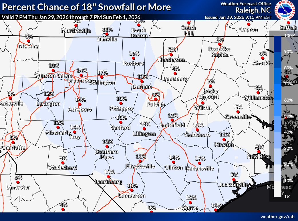
digital snow replied to lilj4425's topic in Southeastern States
Hot off the press! I've never seen a double digit percentage for 18+ in CNC. I like to gamble, let's bring it home!
-
The “I bring the mojo” Jan 30-Feb 1 potential winter storm
digital snow replied to lilj4425's topic in Southeastern States
NWS Bullish with boom scenario -
The “I bring the mojo” Jan 30-Feb 1 potential winter storm
digital snow replied to lilj4425's topic in Southeastern States
-
The “I bring the mojo” Jan 30-Feb 1 potential winter storm
digital snow replied to lilj4425's topic in Southeastern States
My grandpa used to say....That ocean is rather warm Laddie and these bastards always tick NW