

Holston_River_Rambler
-
Posts
5,560 -
Joined
-
Last visited
Content Type
Profiles
Blogs
Forums
American Weather
Media Demo
Store
Gallery
Everything posted by Holston_River_Rambler
-

Leap Days Clipper Parade: February 26th-29th 2020
Holston_River_Rambler replied to John1122's topic in Tennessee Valley
Radar looks promising upstream if it all holds together: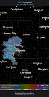
-
Wild Speculation for Winter 20 -21
Holston_River_Rambler replied to Holston_River_Rambler's topic in Tennessee Valley
Thanks @weathertree4u @nrgjeff and @Windspeed for the thoughts on that guy. I saw that Masiello followed him when he created his account, so thought at that time that maybe he had some good info. I suspected he was trying to sell the low solar = better winters or hurricane seasons, but he was pretty obfuscate about how he did it and I just couldn't make heads or tails of it. -
Leap Days Clipper Parade: February 26th-29th 2020
Holston_River_Rambler replied to John1122's topic in Tennessee Valley
Got a nice dusting on some grass and the deck, but that's about it here. -
Leap Days Clipper Parade: February 26th-29th 2020
Holston_River_Rambler replied to John1122's topic in Tennessee Valley
Finally mostly snow for me. -
Leap Days Clipper Parade: February 26th-29th 2020
Holston_River_Rambler replied to John1122's topic in Tennessee Valley
Wind is howling up here in MoCo. One of the windiest cold front passages that I can remember this winter. -
Leap Days Clipper Parade: February 26th-29th 2020
Holston_River_Rambler replied to John1122's topic in Tennessee Valley
A few flakes mixed in on the drive up the plateau in Morgan County. -
February/March 2020 Winter's Last Chance Thread
Holston_River_Rambler replied to John1122's topic in Tennessee Valley
Yeah, the lower heights toward the pole on the Euro look more stretched that I have seen them this winter -
Leap Days Clipper Parade: February 26th-29th 2020
Holston_River_Rambler replied to John1122's topic in Tennessee Valley
RGEM getting a little excited about the second wave: not that is much, but it looks better than the NAM -
Leap Days Clipper Parade: February 26th-29th 2020
Holston_River_Rambler replied to John1122's topic in Tennessee Valley
Kind of hard to see, but the HREF even has some probability of blizzard conditions above maybe 5000 feet: -
Wild Speculation for Winter 20 -21
Holston_River_Rambler replied to Holston_River_Rambler's topic in Tennessee Valley
Same here, lol. -
Fall/Winter Banter 2019-2020
Holston_River_Rambler replied to Carvers Gap's topic in Tennessee Valley
Mt Mitchell for the win: -
February/March 2020 Winter's Last Chance Thread
Holston_River_Rambler replied to John1122's topic in Tennessee Valley
MRX goes with an Special Weater Statement and is pretty bullish for just the Wednesday Night - Thursday system for areas above 2500 ft: ...Wintry Conditions Expected across the far east Tennessee Mountains and Mountains of southwest Virginia for late Wednesday through Thursday Morning... Rain will develop Wednesday as a frontal boundary moves across the region. The periods of rain will change over to snow late Wednesday with snow showers likely through Thursday morning, especially across the higher elevations. Snowfall amounts of 2 to 4 inches are expected at or above 2500 feet across the far east Tennessee Mountains and Mountains of southwest Virginia. Locally higher amounts in excess of 6 inches are possible in the highest peaks of the Smoky Mountains. Travel may become difficult due to snow covered roads and reduced visibility. If you must travel, use caution while driving across higher elevations roads. Across the Plateau, and lower elevations of southwest Virginia and northeast Tennessee, light snow accumulations are possible, mainly on grassy and elevated surfaces. I do wonder sometimes if the plateau is included in this or just Smokies/ Roan, etc... -
February/March 2020 Winter's Last Chance Thread
Holston_River_Rambler replied to John1122's topic in Tennessee Valley
Latest NAM changes Blunderstorm over to snow by nightfall tomorrow: -
Wild Speculation for Winter 20 -21
Holston_River_Rambler replied to Holston_River_Rambler's topic in Tennessee Valley
Anyone want to take a stab at deciphering this guy? -
February/March 2020 Winter's Last Chance Thread
Holston_River_Rambler replied to John1122's topic in Tennessee Valley
EPS still likes the little clippery thingy Friday into Saturday: -
Overnight Euro OP looks pretty good for y'all in terms of its pattern. As is my custom, here is some random map that I don't quite understand, but since I'm still paying these people for access to their stuff, might as well use it for something.
-
February/March 2020 Winter's Last Chance Thread
Holston_River_Rambler replied to John1122's topic in Tennessee Valley
Actually looked fairly interesting with the energy dropping in toward the end of its run: -
February/March 2020 Winter's Last Chance Thread
Holston_River_Rambler replied to John1122's topic in Tennessee Valley
Fair enough, I started the NAO bit this AM, so will get back on track with the 12z UKMET run that looks interesting for KY and parts of W TN: -
I don't think it is off topic at all @Save the itchy algae!. Good questions and a fair point. I think it definitely is, as raindancewx states and you suggest, "relative" given the major recent losses in sea ice up there. I had actually not looked at it and just from hearing what people had been saying, assumed the ++++AO and +++EPO had to rebuild quite a bit. However, sho nuff, you're right. https://nsidc.org/arcticseaicenews/charctic-interactive-sea-ice-graph/ Since it was in banter and raindancewx didn't cite sources, it could be that this article: https://link.springer.com/article/10.1007/s00382-017-3618-9#Sec15 was the one he was using for the claim (conclusions from that study): The spatial pattern of those CI persistent anomalies that lead the NAO by 1 year is quasi-annular about the Arctic-high latitudes coast, extending over the West Baffin Bay-Davis Strait-Labrador coast and the North-East Okhotsk sea (with positive anomalies leading the NAO positive phase). The maximal phase of this co-variability is triggered when a high pressure anomaly develops 1 year before the NAO+ (low pressure for NAO-) over the Central Arctic extending over North Greenland-Canadian Archipelago-Baffin Bay with centres also over the Laptev Sea and North Barents Sea. This “Arctic bridge” appears as a pre-conditioning feature of the maximal NAO phase, being systematic under transient climates. Its role is linked to cold advection over both: the North-Western Atlantic and North-Western Pacific with evaporative ocean cooling, low pressure formation and persistent latent heat advection over the mid-latitudes land. So a persistent, annular, negative meridional thermal gradient is achieved about the Arctic coast, leading positive vorticity over Central Arctic the following year (when leading NAO+). A mode of CI variability captures this pattern and is leading the NAO index by 1 year, having similar spectral properties to the NAO index. The highest leading correlation of this mode is obtained over ([35°N–90°N]), domain that couples the Arctic with the high-latitudes. Another thing to consider is that the NAO is measured at sea level, not higher up where we usually want it for blocking and I'm guessing most researchers, even if they like snow like us, have to go by how the measurement is taken to get their results published. While he may be on shakier ground concerning the sea ice, there has also been talk of the lag after the solar minimum producing an NAO, so I thought I'd look at that too. Probably the most famous once of these is 2009 - 10: and here is the solar plot: That hypothesis also checks out in 1998 or so: It gets less evident in the late 80s though: As you go further back there is a correlation again, but that was also with an favorable AMO, so that could have had a say too.
-
February/March 2020 Winter's Last Chance Thread
Holston_River_Rambler replied to John1122's topic in Tennessee Valley
Hot off the raindancewx press, found it the NE panic room: "Long term, there is a weak correlation between solar activity (annualized) and min/max of Arctic sea ice extent. So the current (relatively) large extent, plus soon to be rising solar activity both support a -NAO in winter next year. If you annualized solar activity to July-June, each year following the min since 1950 has seen a somewhat to very -NAO in winter." -
Satellite actually shows it may have originated near Big Stone Gap: Looks like there were actually three bands, but only one showed up on radar. More to the North aimed at Boone.
-
Bays Mt. Lee band strikes again, this time randomly in the middle of the night (230 - 3 AM). Looks like you have to get the wind at just the right angle. Winds flowing over Bays mt and the three other ridges south of it downsloping and spreading out, then winds banking up against the mountains, then the general flow down the valley:
-
February/March 2020 Winter's Last Chance Thread
Holston_River_Rambler replied to John1122's topic in Tennessee Valley
Overnight Euro continues to advertise some chances after day 5: Lots of moving pieces, but as John pointed out, BL temps look to be a concern. EPS still likes that idea to. Will be interesting to see how the NAM and other meso-models handle these systems. They look much more consolidated which may give the Euro an edge this time, but fiesty, shorter wavelengths may spice things up a bit. -
Clear and cold now. All remaining slush is ice.
-
I'll even add, after looking at the loop a few more times, you can almost see the bands bend more SW as the flow banks up against the Smokies and shunts the flow more SW than S


