

Holston_River_Rambler
-
Posts
5,560 -
Joined
-
Last visited
Content Type
Profiles
Blogs
Forums
American Weather
Media Demo
Store
Gallery
Everything posted by Holston_River_Rambler
-

Fall/Winter Banter - Football, Basketball, Snowball?
Holston_River_Rambler replied to John1122's topic in Tennessee Valley
It's almost SREF plume time boys and girls!!!! Above is for Crossville -
December 2020 Medium/Long Term Pattern Discussion.
Holston_River_Rambler replied to John1122's topic in Tennessee Valley
For you western TN folks, the 18z 3km NAM looking interesting towards 10 PM and midnight Sunday night into the wee hours of Monday AM: Looks like it is associated with the 500 mb vort, as the N stream races in to try and catch it. Meanwhile, for those of us further east, the 18z RGEM still handling the secondary N. stream energy a little more aggressively: And it's not all upslope driven. Not quite sure if we get in the left exit region of the jet to the south over GA and the Carolinas, but we're close. -
December 2020 Medium/Long Term Pattern Discussion.
Holston_River_Rambler replied to John1122's topic in Tennessee Valley
Sorry I was talking about a different one, just as an addendum to what you had already said. Should have been clearer in how I phrased it. -
December 2020 Medium/Long Term Pattern Discussion.
Holston_River_Rambler replied to John1122's topic in Tennessee Valley
EPS looked like it was seeing a signal for anther Gulf storm at the end of its run. Too far out to say much more than that for now. -
December 2020 Medium/Long Term Pattern Discussion.
Holston_River_Rambler replied to John1122's topic in Tennessee Valley
I will say the 6z RGEM has an interesting solution at the end of its run. The initial low does run up west of the Apps, but N Stream energy drops in and cuts off and provides some lift: -
December 2020 Medium/Long Term Pattern Discussion.
Holston_River_Rambler replied to John1122's topic in Tennessee Valley
Looking more and more like it will make a run up just west of or over the Apps. Still time for some surprises though. On the bright side, the EPS members see hope for at least a solid dusting for the usual upslope areas and even a chance for valley areas: -
December 2020 Medium/Long Term Pattern Discussion.
Holston_River_Rambler replied to John1122's topic in Tennessee Valley
Sunrise over our little N stream friend in the Gulf of Alaska: -
December 2020 Medium/Long Term Pattern Discussion.
Holston_River_Rambler replied to John1122's topic in Tennessee Valley
FWIW the 12z Ukie is even further east now, from being the furthest west: -
December 2020 Medium/Long Term Pattern Discussion.
Holston_River_Rambler replied to John1122's topic in Tennessee Valley
This is a little bit bantery, but it is a holiday, so why not? Aren't we in that weird window we sometimes notice between days 3 - 5 when models lose storms or flip-flop, only for them to pop back up. -
Fall/Winter 20-21 General Observations
Holston_River_Rambler replied to John1122's topic in Tennessee Valley
Pics from my Frozen Head Turkey Trot today: Time lapse video looking SE: https://imgur.com/a/objhsi8 Other pics from Chimney Tops and the Lookout Tower: Looking N: Looking SE: Looking WSW: Looking NW towards Wartburg and the Obed: -
December 2020 Medium/Long Term Pattern Discussion.
Holston_River_Rambler replied to John1122's topic in Tennessee Valley
Euro has come east some at 12z, but not enough. Surface low runs right up I 75 in the eastern valley. -
December 2020 Medium/Long Term Pattern Discussion.
Holston_River_Rambler replied to John1122's topic in Tennessee Valley
6z EPS MSLPs are a little(and I mean a tad) further south, but still a pretty tight wad of 'em around TN: 6z: 0z -
December 2020 Medium/Long Term Pattern Discussion.
Holston_River_Rambler replied to John1122's topic in Tennessee Valley
6z Euro doesn't quite out as far as we would like, but it does look east of 0z run: 6z: 0z: Southern stream energy was more open and the N stream can bully it more easterly -
December 2020 Medium/Long Term Pattern Discussion.
Holston_River_Rambler replied to John1122's topic in Tennessee Valley
Here are the GEFS member lows for comparison to the EPS above: -
December 2020 Medium/Long Term Pattern Discussion.
Holston_River_Rambler replied to John1122's topic in Tennessee Valley
Sorry got a little carried away with gifs on that one and forgot to add that the EPS has jumped west some, but is not as far west as the OP. This close to the day of, it may be expected that the ensembles, run off the west OP, would jump some. -
December 2020 Medium/Long Term Pattern Discussion.
Holston_River_Rambler replied to John1122's topic in Tennessee Valley
Overnight Euro jumped west again. Looks a lot like the UKMET has for the past couple of days. 6z GFS now looks more like the Euro did yesterday. The UKMET, which has been pretty steady the past few days with a cutter over Nashville has now, you guessed it, become the most easterly of the OPs with its depiction of the surface low (shown below for dramatic effect, lol) The UKMET has the northern stream system is slower, so the cold air is late to the party Not sure how the UKMET does when streams cross though. -
Fall/Winter 20-21 General Observations
Holston_River_Rambler replied to John1122's topic in Tennessee Valley
Success!!!!! I must not have read what you said carefully enough, lol. Sorry!!! I've been trying to figure this out for a while. -
Fall/Winter 20-21 General Observations
Holston_River_Rambler replied to John1122's topic in Tennessee Valley
It may be because I'm making them hidden posts. I had somebody try to preach to me about titles on Imgur when I uploaded a storm pic publicly once and decided I didn't care enough after that to make them public. I will try it again though, to see if it lets me link them. In terms of obs. coming back up onto the plateau the fog rolled in and was thick in places. And Kingsport still has a lot more leaves than we do here. I even saw a tree in the N slope of Bays Mt that still looked like it was a pale green. -
Fall/Winter 20-21 General Observations
Holston_River_Rambler replied to John1122's topic in Tennessee Valley
I tried that stovepipe with the following link but it wouldn’t allow this link: https://imgur.com/a/fAAIbyn -
Fall/Winter 20-21 General Observations
Holston_River_Rambler replied to John1122's topic in Tennessee Valley
Another good sunset this PM Powell. Driving through Powell and Claxton towards home. I do t have tapatalk. I should probably get it if it helps with pics. https://imgur.com/a/zIedxHD -
December 2020 Medium/Long Term Pattern Discussion.
Holston_River_Rambler replied to John1122's topic in Tennessee Valley
Precip and 850 temps too nice not to share too sorry for multiple posts but trying to do all this from my phone now -
December 2020 Medium/Long Term Pattern Discussion.
Holston_River_Rambler replied to John1122's topic in Tennessee Valley
-
December 2020 Medium/Long Term Pattern Discussion.
Holston_River_Rambler replied to John1122's topic in Tennessee Valley
EPS still looking good and even a little east of the OP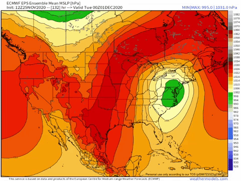
-
December 2020 Medium/Long Term Pattern Discussion.
Holston_River_Rambler replied to John1122's topic in Tennessee Valley
I saw that MRX overnight mentioned the WPC and hadn't looked at their maps yet: not unhappy with that look 5 days out. -
December 2020 Medium/Long Term Pattern Discussion.
Holston_River_Rambler replied to John1122's topic in Tennessee Valley
EPS mean looks more like the OP overnight: A question I have looking at this mean, is will the Surface Low try to jump to or at least toward the coast? I don't really understand the dynamic between a surface low and its upper level support. Sure, give me a normal shortwave on satellite and I think I could ball park where the surface reflection would show up, but this seems like it will be a unique lil beastie. I have a gif saved of a storm whose 500mb vorticity evolution reminds me of this one, but I won't say it out loud. The energy looked stronger with that one and it all came together further south. The 6z GEFS is still a west of the Euro, but seems to be getting a little closer to its solution, especially in the means as the storm develops and heads NE:
