

purduewx80
-
Posts
1,705 -
Joined
Content Type
Profiles
Blogs
Forums
American Weather
Media Demo
Store
Gallery
Everything posted by purduewx80
-
Wintry mix potential weekend of Jan 18-19, 2020
purduewx80 replied to wdrag's topic in New York City Metro
Airport totals as of 00Z: EWR - 1.8" LGA - 1.9" JFK - 1.6" -
Wintry mix potential weekend of Jan 18-19, 2020
purduewx80 replied to wdrag's topic in New York City Metro
Mixed precip and/or sleet is steadily moving our way. Some dynamic cooling may offset this at times, as is the case near the PA/NJ border now. -
Wintry mix potential weekend of Jan 18-19, 2020
purduewx80 replied to wdrag's topic in New York City Metro
curious to see how we do this evening. should be pretty close to the rain/heavy snow line for a bit. -
Wintry mix potential weekend of Jan 18-19, 2020
purduewx80 replied to wdrag's topic in New York City Metro
not quite but closing in on it. huge flakes again now. -
Wintry mix potential weekend of Jan 18-19, 2020
purduewx80 replied to wdrag's topic in New York City Metro
yeah this held together nicely. snow growth was good for about 30 minutes, but it's back to small flakes now in BK. -
Wintry mix potential weekend of Jan 18-19, 2020
purduewx80 replied to wdrag's topic in New York City Metro
The increase in winds associated with this frontogenetic band are interesting. EWR began gusting just as it arrived. Radar velocities indicate winds will die down again as the more intense snow ends. KEWR 181723Z 23016G22KT 2SM -SN BKN027 BKN042 OVC060 M02/M12 A3042 RMK AO2 SNB22 P0000 T10221122 -
Wintry mix potential weekend of Jan 18-19, 2020
purduewx80 replied to wdrag's topic in New York City Metro
You're far enough north to see mostly snow before the dry slot moves in. Should do well up there. -
Wintry mix potential weekend of Jan 18-19, 2020
purduewx80 replied to wdrag's topic in New York City Metro
Walt's post above addresses this. Parts of the 5 boroughs may see some mixing prior to going back to mdt/hvy snow, but I think this (mix/rain) is most likely in SI, BK, southern Queens/LI due to the rapidly increasing LLJ off the relatively milder ocean. For now most of the soundings support this scenario. -
Wintry mix potential weekend of Jan 18-19, 2020
purduewx80 replied to wdrag's topic in New York City Metro
Agreed - I like the ~6-8PM window for potential +SN in northern Queens/LI, Manhattan, CT and points north. -
Wintry mix potential weekend of Jan 18-19, 2020
purduewx80 replied to wdrag's topic in New York City Metro
The models unanimously weaken that fronto forcing between 700-500mb where the DGZ is, so if this is correct, +SN may not make it into the area this afternoon.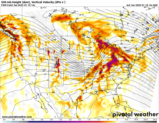
-
Wintry mix potential weekend of Jan 18-19, 2020
purduewx80 replied to wdrag's topic in New York City Metro
That dry air goes all the way up past 700mb.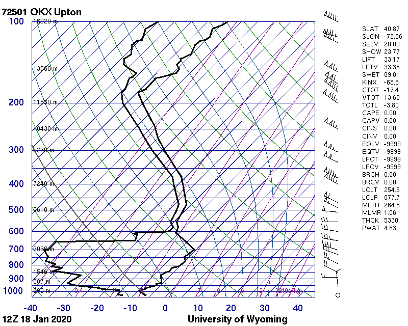
-
January 2020 General Discussions & Observations Thread
purduewx80 replied to Rtd208's topic in New York City Metro
Got in on the 00Z ob.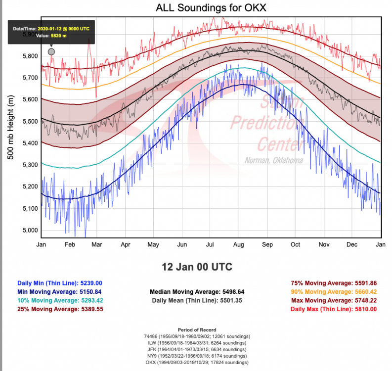
-
January 2020 General Discussions & Observations Thread
purduewx80 replied to Rtd208's topic in New York City Metro
-
January 2020 General Discussions & Observations Thread
purduewx80 replied to Rtd208's topic in New York City Metro
-
January 2020 General Discussions & Observations Thread
purduewx80 replied to Rtd208's topic in New York City Metro
Same. Low-level flow ended up more southwesterly vs southerly, and our cold high that moved offshore had plenty of dry air feeding out of it. Lack of precip, farther W/NW low/front and sun = deeper mixing. EWR has gusts to 40MPH now. -
January 10th-12th Winter Storm Potential
purduewx80 replied to Thundersnow12's topic in Lakes/Ohio Valley
This is really interesting. I think there is some seeding from above going on. Aircraft soundings from ORD, MDW and MKE show temps around 1KM up -4 to -5C but there is about 5000' of temps above freezing above that. I'd have thought the light precip from the higher cloud layers would entirely melt before being able to seed the lake-effect precip, but maybe not given the snow reports? -
January 10th-12th Winter Storm Potential
purduewx80 replied to Thundersnow12's topic in Lakes/Ohio Valley
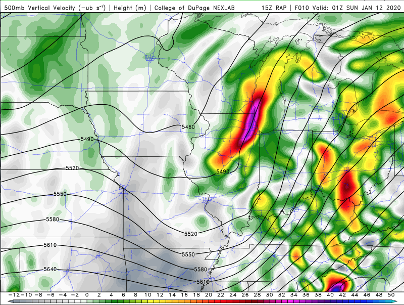
Yeah, there is plenty of evidence for a 2-3 hour period of heavy snow this evening. The latest RAP shows strong lift (best just above the DGZ) and banding potential. The lake should also continue to contribute with 0-1km lapse rates near 10C/km (when modified for lake temps).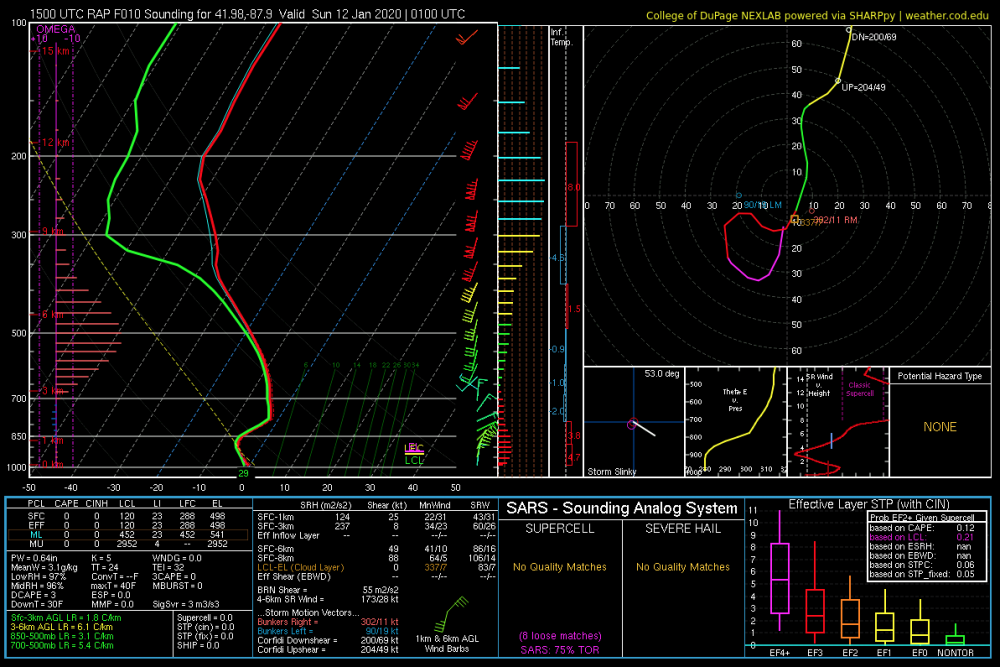
-
January 2020 General Discussions & Observations Thread
purduewx80 replied to Rtd208's topic in New York City Metro
KNYC up to 65 at 11. Already 2F over the previous record. -
January 2020 General Discussions & Observations Thread
purduewx80 replied to Rtd208's topic in New York City Metro
The 12Z Sunday ISP sounding indicates weak CAPE and an 80KT LLJ! The surface inversion obviously won't let that all mix down, but it certainly could get interesting if any convective elements survive. Its PWAT forecast would also set a January record at OKX. -
January 10th-12th Winter Storm Potential
purduewx80 replied to Thundersnow12's topic in Lakes/Ohio Valley
Alternatively, this is the kind of convective outbreak that will pump the SE ridge enough to allow the warm air aloft to overspread surface cooling. That's why we're seeing a band of sleet and freezing rain. -
January 10th-12th Winter Storm Potential
purduewx80 replied to Thundersnow12's topic in Lakes/Ohio Valley
MSN will definitely do well. MTW to SBM is probably the sweet spot with lake enhancement. -
January 10th-12th Winter Storm Potential
purduewx80 replied to Thundersnow12's topic in Lakes/Ohio Valley
haha yeah I figured you were. 06Z ECMWF held serve with mostly a mix for Chicago and +SN in WI. I tend to think it will perform better with the -PNA and trough digging S just off the West Coast, but a model blend is still reasonable this far out. -
January 10th-12th Winter Storm Potential
purduewx80 replied to Thundersnow12's topic in Lakes/Ohio Valley
It's a blended/ensemble product that takes all the guidance into account. -
The cold front moves through during peak "heating" this afternoon. Conditions are most favorable from ~1-4PM when CAPE is maximized and we have low-level convergence w/ the front.
-
BGM radar is down. Given how low the tops are with these, they may not show up until closer in (within range of OKX and DIX); vis sat is getting bubbly in NE PA and adjacent areas.


