purduewx80
-
Posts
1,705 -
Joined
Content Type
Profiles
Blogs
Forums
American Weather
Media Demo
Store
Gallery
Everything posted by purduewx80
-
A United flight had to return to ORD after flying through a hail core over Lake Michigan. PIREP: ORD UA /OV ORD090035/TM 1925/FL155/TP A320/RM HAIL-CRACKED WIND SHIELD
-
Few elevated flash/bangs here over the past hour. Severe warning for Lake/Porter Co, IN for hail and psbl winds.
-
"In addition to the polyclonal antibodies, the President has been taking zinc, vitamin D, famotidine, melatonin and a daily aspirin." But where's the hydroxychloroquine?
-
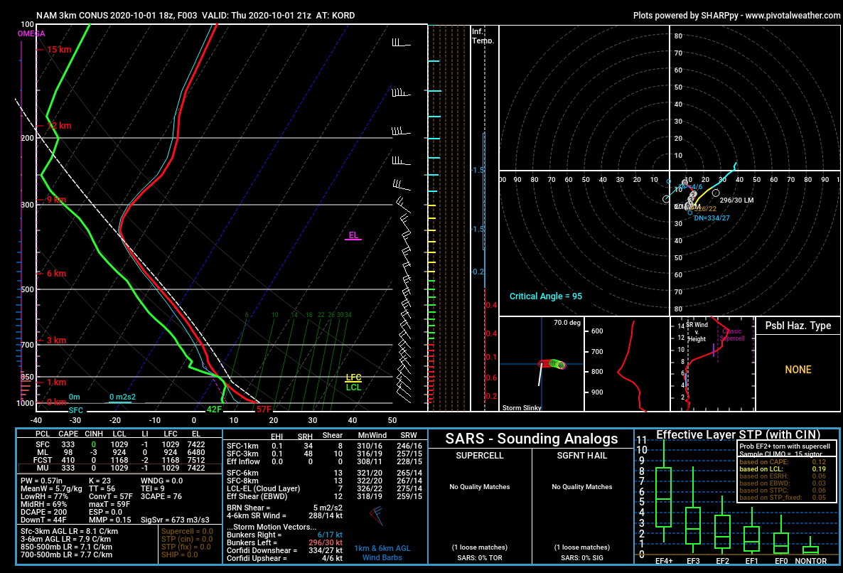
The fact that the hail growth zone (-10C to -30C) is closer to the ground and surface temps aren't all that warm help it reach the ground. Nice forecast profile from the 3km NAM, showing the steep surface to mid-level lapse rates. Not a ton of CAPE but it was obviously more than enough for the heavy showers and isolated storms this afternoon.

-
Beauties. Had some small hail here shortly before 5.
-
Obviously smoky in the upper levels today. I guess to many it looks like a veil of cirrus. The sun should have that tell-tale red glow again towards sunset.
-
2020 Record Hot/Warm Summer For Chicago
purduewx80 replied to Chicago Storm's topic in Lakes/Ohio Valley
meh. chicago will continue to expand into the burbs, and the burbs will continue to expand. it's not like UHI warming is fake - we all feel it. -
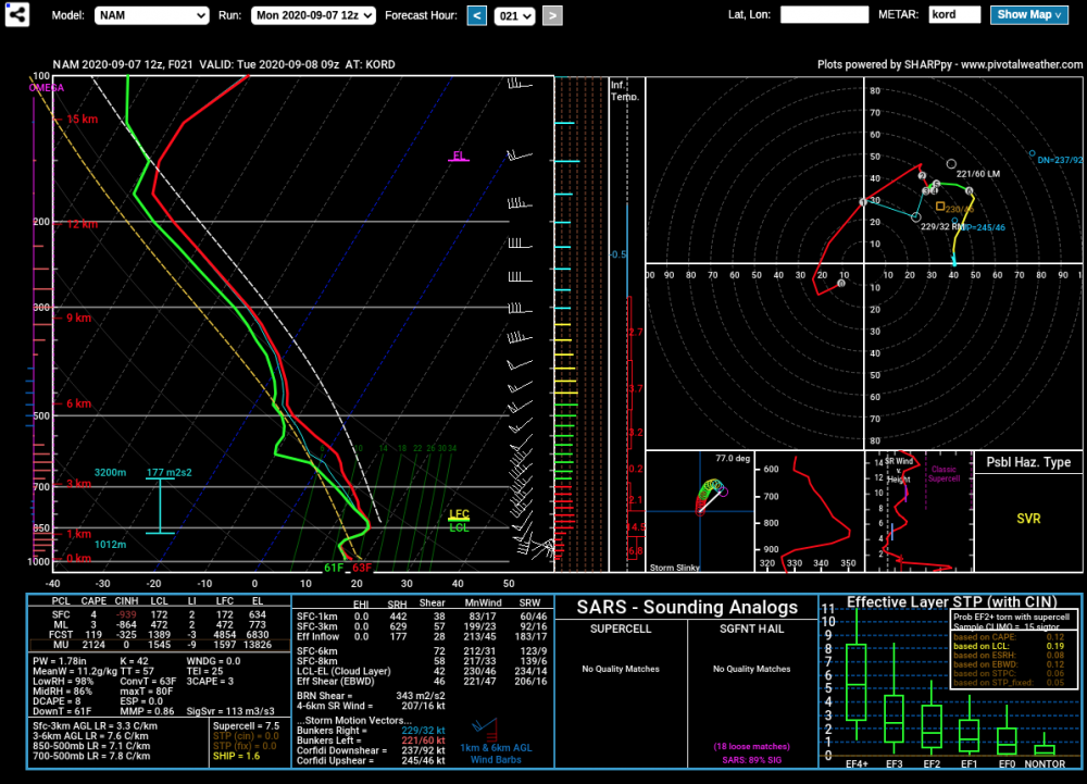
Think there is at least a marginal risk for severe hail across the region overnight as the 850 warm front lifts into northern IL. Mid-level flow is strongest near and north of the IL/WI border. Lapse rates are steep and there is a decent amount of both directional and speed shear such that some transient supercell structures are probable. 12Z NAM for ORD valid at 09Z below:
-
it's incredibly sad you still believe this.
-
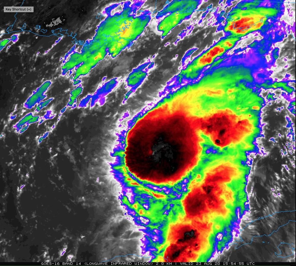
Nice expansion of the CDO over the past hour and a warm spot (psbl eye) in the middle.

-
wake me up when your at-risk kid catches it and you're still downplaying everything.
-
Initial estimates of crop damage alone are $3.4 billion. Who'd have thought an August derecho would be on 2020's list of billion dollar disasters?
-
I love these:
-
-
HRRR and HRRRx did well, as did the RPM (IBM/WSI's ARW), IBM GRAF and the hi-res Canadian (HRDPS).
-
-
LOT just issued a high wind warning for the back side.
-
DPA gusting to 60MPH now behind the line.
-
Now 72 MPH
-
Spotter report of golf-ball sized hail in the line near Plainfield. Almost hard to believe, but if true, extra damaging when associated with severe winds.
-
-
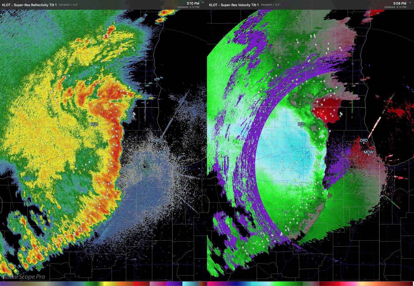
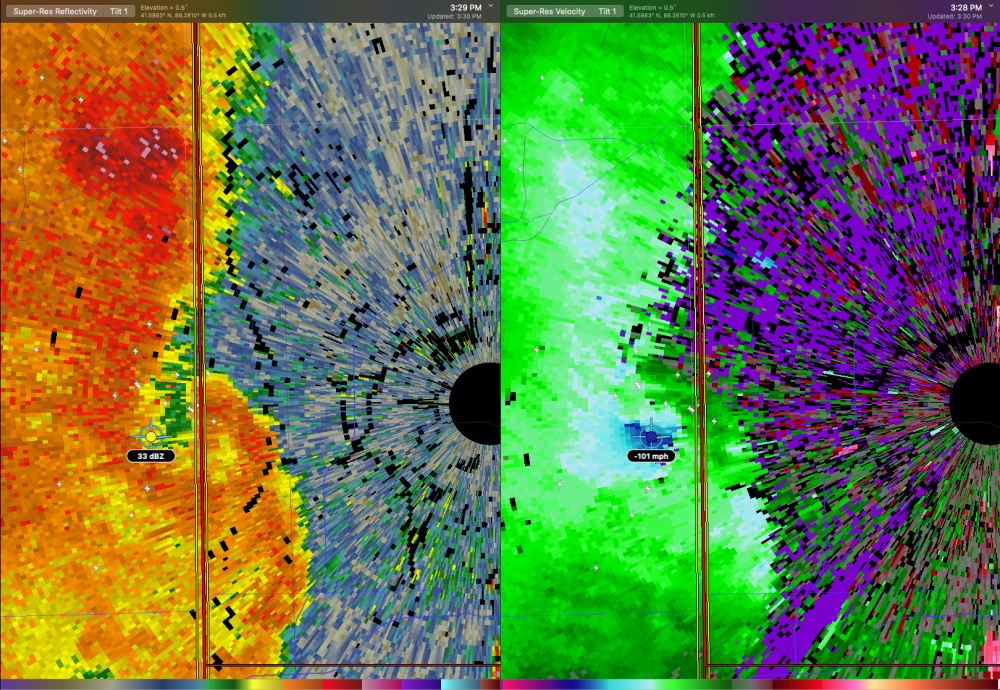
One of those microscale circulations is just west of KLOT radar, which is estimating 100-105MPH winds 500' above the ground, so likely reaching the surface. KLOT will probably go down if it holds together.
-
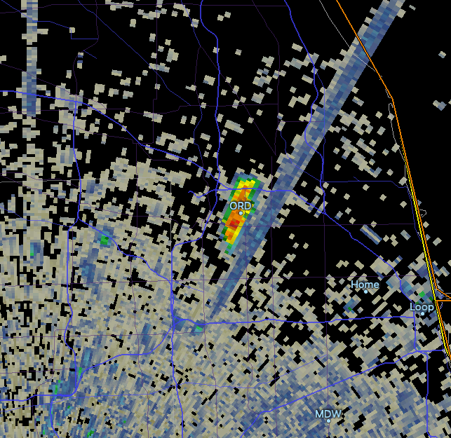
Unrelated, but there is a large fire in Franklin Park. The smoke plume shows up on radar over O'Hare.
-
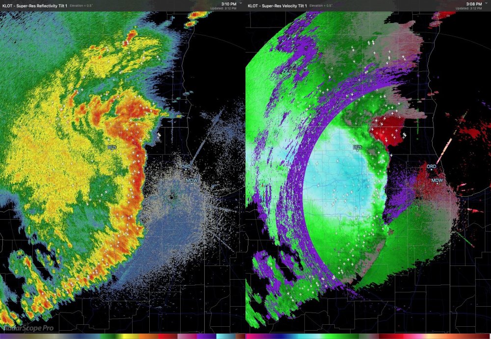
strongest winds on the leading edge are associated with microscale bows and are more isolated. note the stronger/longer duration winds are associated with lighter precip, indicative of the downward motion associated with the descending rear inflow jet (blue areas in velocity on the right-most image).
-
Other way around