Sw NC weather
-
Posts
583 -
Joined
-
Last visited
Content Type
Profiles
Blogs
Forums
American Weather
Media Demo
Store
Gallery
Everything posted by Sw NC weather
-

2023-2024 Fall/Winter Mountain Thread
Sw NC weather replied to The Alchemist's topic in Southeastern States
GFS keeps the good vibes going. 4”-8” for the southern mountains. -
2023-2024 Fall/Winter Mountain Thread
Sw NC weather replied to The Alchemist's topic in Southeastern States
12z Nam didn’t get all the way to us, but definitely trended in the right direction. I don’t see GSP putting anything up till tomorrow morning unless things are looking great this afternoon. -
2023-2024 Fall/Winter Mountain Thread
Sw NC weather replied to The Alchemist's topic in Southeastern States
I believe that one trended back NW to us, but could be wrong. No need to get worried at this point we’re one 50 mile shift away from a 4-8” event for us. -
2023-2024 Fall/Winter Mountain Thread
Sw NC weather replied to The Alchemist's topic in Southeastern States
No need to stress the wobbles guys. We’re only 30-50 miles from still being in the bullseye. I don’t wanna be there 5 days out anyways. -
2023-2024 Fall/Winter Mountain Thread
Sw NC weather replied to The Alchemist's topic in Southeastern States
Trend has been our friend today! Hopefully we can keep it going.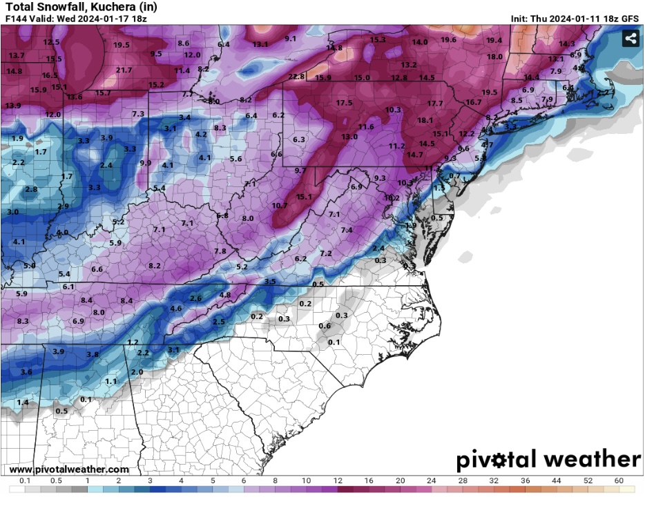
-
2023-2024 Fall/Winter Mountain Thread
Sw NC weather replied to The Alchemist's topic in Southeastern States
First dusting of the year down this way. About 1/2” on elevated surfaces. -
2023-2024 Fall/Winter Mountain Thread
Sw NC weather replied to The Alchemist's topic in Southeastern States
Rain/Snow mix falling in Northern Macon County at 37 degrees. Maybe will drop below freezing and get our first dusting of the year. -
2023-2024 Fall/Winter Mountain Thread
Sw NC weather replied to The Alchemist's topic in Southeastern States
Highlands Gorge just got shut down. Assuming a land slide. Water is out everywhere. -
2023-2024 Fall/Winter Mountain Thread
Sw NC weather replied to The Alchemist's topic in Southeastern States
Minor flooding already occurring here in Macon county. Lots of rain still to come. -
2023-2024 Fall/Winter Mountain Thread
Sw NC weather replied to The Alchemist's topic in Southeastern States
GFS took a step in the right direction for next weeks event. Still aways to go but it’s something to track atleast. -
2023-2024 Fall/Winter Mountain Thread
Sw NC weather replied to The Alchemist's topic in Southeastern States
I’m at 32.3 in Northern Macon. I’ll skyrocket up before precip moves in. I only get ice once every 7-8 years with a real strong wedge. Good luck to the rest and be careful out. -
2023-2024 Fall/Winter Mountain Thread
Sw NC weather replied to The Alchemist's topic in Southeastern States
Lots of details to iron out, but if the low was about 50-100 miles further south we would be hammered with the deform band. Realistically that’s probably my only chance at seeing much from this system. -
2023-2024 Fall/Winter Mountain Thread
Sw NC weather replied to The Alchemist's topic in Southeastern States
A track like what the GFS showing in early January. We should be digging out! Oh well, I still think there’s a chance for the higher elevation people from Haywood north. -
2023-2024 Fall/Winter Mountain Thread
Sw NC weather replied to The Alchemist's topic in Southeastern States
GFS and Icon both shifted north some at 18z. Maybe this system has some legs. No need to get to invested until 12z tomorrow. -
2023-2024 Fall/Winter Mountain Thread
Sw NC weather replied to The Alchemist's topic in Southeastern States
I know it’s the Nam at range, but it’s something to look at.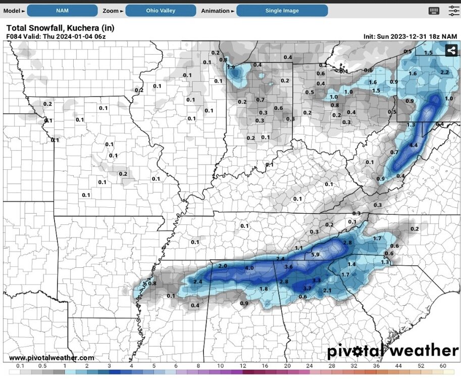
-
2023-2024 Fall/Winter Mountain Thread
Sw NC weather replied to The Alchemist's topic in Southeastern States
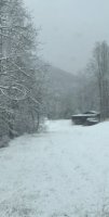
First car topper of the year in Northern Macon County. Flurries still flying. -
2023-2024 Fall/Winter Mountain Thread
Sw NC weather replied to The Alchemist's topic in Southeastern States
GFS is consist on a ULL swinging through the area on Friday and bringing a stout upslope snow. Hopefully it’s on to something, other models have hinted at it as well. -
2023-2024 Fall/Winter Mountain Thread
Sw NC weather replied to The Alchemist's topic in Southeastern States
Models are starting to show the first real threat window is gonna be Dec 30th - Jan 2nd. Euro had a solid 4-6” event for us on the 1st at 0z. -
2023-2024 Fall/Winter Mountain Thread
Sw NC weather replied to The Alchemist's topic in Southeastern States
Just had to run out and actually quite a few flakes mixing in here down to 39 now. Around 2400’ elevation. -
2023-2024 Fall/Winter Mountain Thread
Sw NC weather replied to The Alchemist's topic in Southeastern States
Moisture coming thru north GA is looking promising. Starting to think I may see a few flakes. Y’all from Haywood North above 3000’ wouldn’t be surprised to see a inch or two. -
2023-2024 Fall/Winter Mountain Thread
Sw NC weather replied to The Alchemist's topic in Southeastern States
Just had a rain shower push through. Maybe it’s my imagination but I would’ve swore there was a few snowflakes mixed in. Sitting at 39 and slowly dropping. Here’s to hoping for a car topper in the morning and good luck to you higher elevation people. -
2023-2024 Fall/Winter Mountain Thread
Sw NC weather replied to The Alchemist's topic in Southeastern States
Typical strong El nino is warm December transition in January and a cold February. Not saying that’ll be the case but nothing to get worked up about at this point. On a side note I’m happy with the December look and think it may hold a surprise due to a -NAO developing. -
2023-2024 Fall/Winter Mountain Thread
Sw NC weather replied to The Alchemist's topic in Southeastern States
Received some much needed rain this morning. Don’t know exact amount since my gauge is down at the moment but I’d bet a good 1/4” fell last night and this morning. -
2023 Mountains Spring/Summer Thread
Sw NC weather replied to Tyler Penland's topic in Southeastern States
Some big storms rolling through this evening with a temp of 63. Reminds me of how much I’m ready for fall. -
2023 Mountains Spring/Summer Thread
Sw NC weather replied to Tyler Penland's topic in Southeastern States
Models are shifting the tropical storm to far south for us to get much benefit, but Monday and Tuesday look quite wet around here so hopefully we can score some rain that way.

