Sw NC weather
-
Posts
583 -
Joined
-
Last visited
Content Type
Profiles
Blogs
Forums
American Weather
Media Demo
Store
Gallery
Everything posted by Sw NC weather
-

2024-2025 Fall/Winter Mountain Thread
Sw NC weather replied to Buckethead's topic in Southeastern States
Closing in on 2”. Rates are still great but flake size is way down. Still think there’s a chance I make a run for 4-5”. -
2024-2025 Fall/Winter Mountain Thread
Sw NC weather replied to Buckethead's topic in Southeastern States
Straight pounding here right now. Prob 1”+/ hr rates at the moment. -
2024-2025 Fall/Winter Mountain Thread
Sw NC weather replied to Buckethead's topic in Southeastern States
Rates are beginning to pick up again. Hopefully flake size will increase as well. Getting close to a 1.5” here -
2024-2025 Fall/Winter Mountain Thread
Sw NC weather replied to Buckethead's topic in Southeastern States
Rates are starting to come back up again. Almost to 1” here. Hopefully the good returns around Chattanooga give us some good rates in a couple of hours. -
2024-2025 Fall/Winter Mountain Thread
Sw NC weather replied to Buckethead's topic in Southeastern States
Moderate snow seems to have set in. Closing in on a 1/2” here in Cowee. -
2024-2025 Fall/Winter Mountain Thread
Sw NC weather replied to Buckethead's topic in Southeastern States
Everything has whitened back up already, granted all the north sides where white still from the snow earlier in the week. -
2024-2025 Fall/Winter Mountain Thread
Sw NC weather replied to Buckethead's topic in Southeastern States
Finally, light to moderate snow falling. Had flurries for 20-30 minutes before this moved in. -
2024-2025 Fall/Winter Mountain Thread
Sw NC weather replied to Buckethead's topic in Southeastern States
Light snow flying in highlands. Shouldn’t be long. -
2024-2025 Fall/Winter Mountain Thread
Sw NC weather replied to Buckethead's topic in Southeastern States
I’m done looking at models for this one. Time to just enjoy the snow! Just 6 hrs ago the hrrr showed a 1/2” for atl. A lot of places down there have 2-3” and still falling. Hopefully that means we can stay all snow and rack up 6” or so. -
2024-2025 Fall/Winter Mountain Thread
Sw NC weather replied to Buckethead's topic in Southeastern States
Up to 24 degrees here. We’ve had virga for 2 hrs now. I’d expect snow to start around 9 here. -
2024-2025 Fall/Winter Mountain Thread
Sw NC weather replied to Buckethead's topic in Southeastern States
6z GEFS continues the upward trend this morning. Gonna be a fun day of tracking!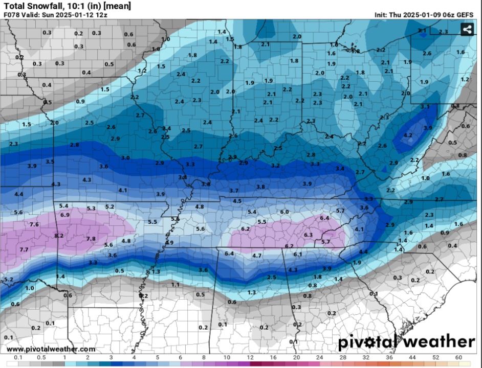
-
2024-2025 Fall/Winter Mountain Thread
Sw NC weather replied to Buckethead's topic in Southeastern States
Big south shift on the Rap. Was really juiced up to, if not for sleet in the heart of the storm it would’ve been even bigger. Globals look good, time to get the short range models on our side. See new run on the bottom.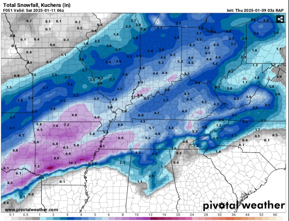
-
2024-2025 Fall/Winter Mountain Thread
Sw NC weather replied to Buckethead's topic in Southeastern States
18z EPS with a nice uptick as well. Feels like it’s been a long time since us valley people have seen a good 4-8 inch event.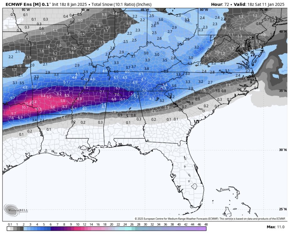
-
2024-2025 Fall/Winter Mountain Thread
Sw NC weather replied to Buckethead's topic in Southeastern States
18z model runs have trended more favorably for us. See the Euro below. Hopefully we can keep the momentum going into the system.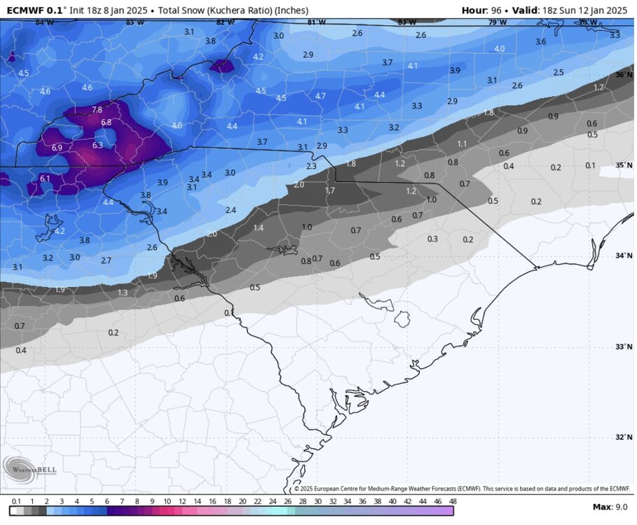
-
2024-2025 Fall/Winter Mountain Thread
Sw NC weather replied to Buckethead's topic in Southeastern States
Fine flakes pouring down in Northern Macon. Everything starting to get covered. Seems like it’s been a while that we’ve had a good winter stretch like we seem to be entering. Hopefully fun times ahead. -
2024-2025 Fall/Winter Mountain Thread
Sw NC weather replied to Buckethead's topic in Southeastern States
Light snow in Highlands with temp of 36 -
2024-2025 Fall/Winter Mountain Thread
Sw NC weather replied to Buckethead's topic in Southeastern States
Very solid GFS run for Friday and Saturday. Models are starting to somewhat come more aligned with earth other. GEFS and EPS both have a mean over 3” for us mountain ppl. Hold this look through 12z Tuesday and will be cooking.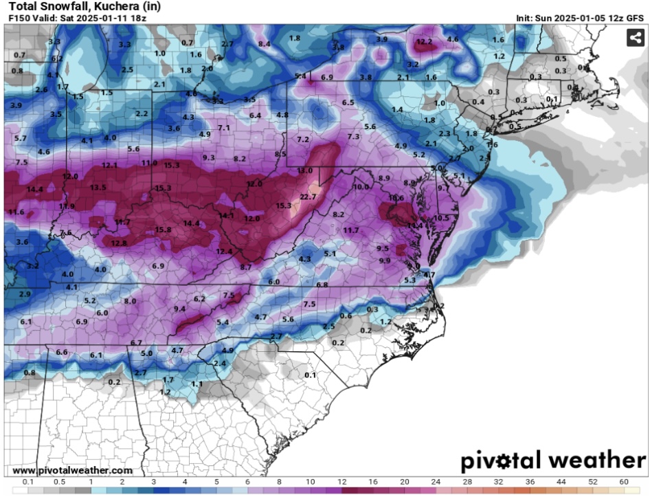
-
2024-2025 Fall/Winter Mountain Thread
Sw NC weather replied to Buckethead's topic in Southeastern States
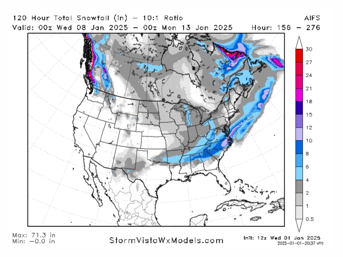
Euro AI is looking good for the same time frame as the GFS. Definitely believe this is our best shot at a big storm. Ratios shown are 10:1, would definitely be better than that in this case.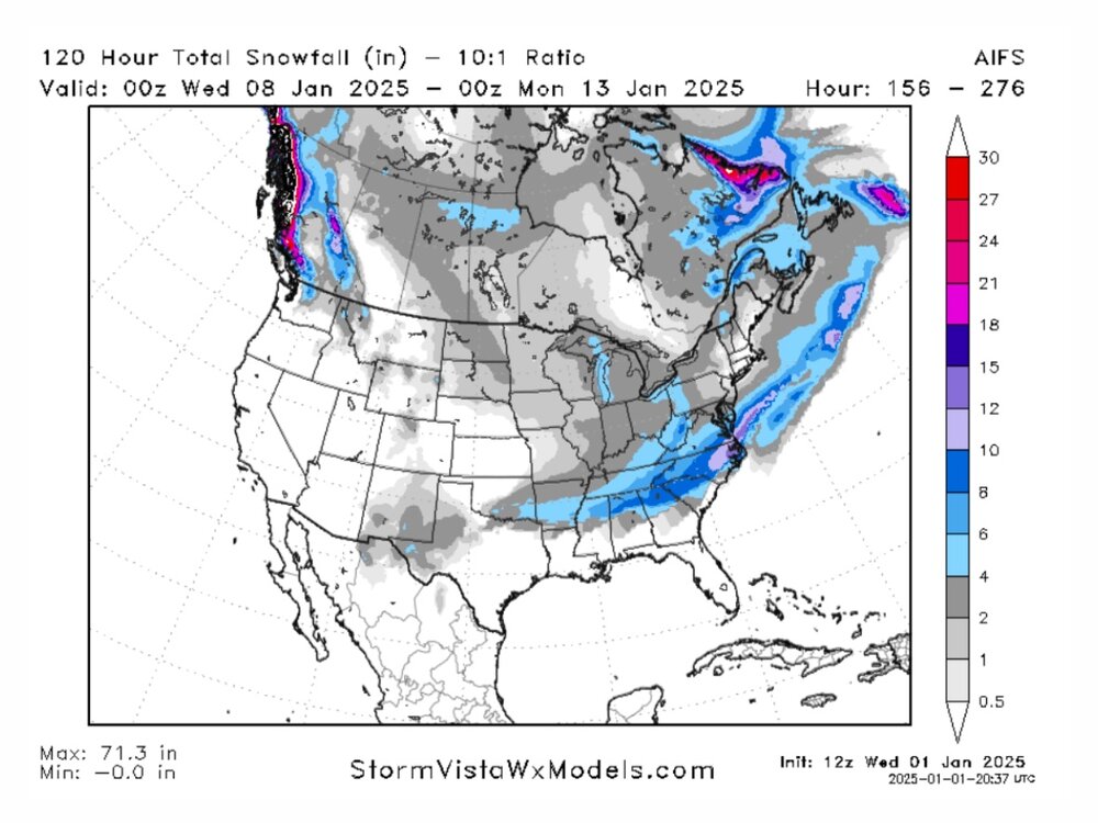
-
2024-2025 Fall/Winter Mountain Thread
Sw NC weather replied to Buckethead's topic in Southeastern States
With the rain moving out. Feels like the can start looking at our winter potential. The first shot looks to be new years morning with some nw flow snow along the border. Then cold and possible big dog potential comes. Lots of energy flying around so it’ll be hard to nail anything down at much lead time. I’ve got a feeling they’ll be a lo to track in the next few days. Better rest up. -
2024-2025 Fall/Winter Mountain Thread
Sw NC weather replied to Buckethead's topic in Southeastern States
There’s a few flurries flying here the last 30 minutes. -
2024-2025 Fall/Winter Mountain Thread
Sw NC weather replied to Buckethead's topic in Southeastern States
A good dusting here in northern Macon county. -
2024-2025 Fall/Winter Mountain Thread
Sw NC weather replied to Buckethead's topic in Southeastern States
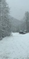
Light snow has started here. Vehicles are getting white. Hoping for a good dusting in the morning. -
2024-2025 Fall/Winter Mountain Thread
Sw NC weather replied to Buckethead's topic in Southeastern States
Moderate snow now with vehicles white and grass getting frosty. Exceeding expectations, I thought a car topper at best. -
2024-2025 Fall/Winter Mountain Thread
Sw NC weather replied to Buckethead's topic in Southeastern States
Decent snow shower in Northern Macon with a temp of 34. -
2024-2025 Fall/Winter Mountain Thread
Sw NC weather replied to Buckethead's topic in Southeastern States
First frost of the season, 34 in Northern Macon this morning.