Sw NC weather
-
Posts
583 -
Joined
-
Last visited
Content Type
Profiles
Blogs
Forums
American Weather
Media Demo
Store
Gallery
Everything posted by Sw NC weather
-

2020/2021 Fall/Winter Mountain thread
Sw NC weather replied to Met1985's topic in Southeastern States
Yeah it went down hill real fast here! -
2020/2021 Fall/Winter Mountain thread
Sw NC weather replied to Met1985's topic in Southeastern States
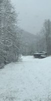
It’s awesome out there. I can’t get video to load but here at the house there’s almost 2 inches and still ripping! Think we might make a run at 4. -
2020/2021 Fall/Winter Mountain thread
Sw NC weather replied to Met1985's topic in Southeastern States
I’m about 3500’ right now we’ll over an inch and it’s still pounding with wind ripping. Visibility at time is less than 50 feet! -
2020/2021 Fall/Winter Mountain thread
Sw NC weather replied to Met1985's topic in Southeastern States
Get ready fellas it’s insane we might should be under blizzard warning no joke. I’ll post videos in a little bit. -
2020/2021 Fall/Winter Mountain thread
Sw NC weather replied to Met1985's topic in Southeastern States
10 degree drop in 15 minutes and wind is howling. Craziest thing I’ve seen weather wise in awhile! -
2020/2021 Fall/Winter Mountain thread
Sw NC weather replied to Met1985's topic in Southeastern States
Temps falling off a cliff 6 degrees in 5 minutes. -
2020/2021 Fall/Winter Mountain thread
Sw NC weather replied to Met1985's topic in Southeastern States
No joke! The latest hrrr shows 3-6” for most of WNC by midnight. I think we might lose a little to melt but with intense rates it should lay fairly quickly. -
2020/2021 Fall/Winter Mountain thread
Sw NC weather replied to Met1985's topic in Southeastern States
I know I don’t need to get reeled into the backside of the main precip but man oh man models are trying to reel me in. -
2020/2021 Fall/Winter Mountain thread
Sw NC weather replied to Met1985's topic in Southeastern States
These short range models are showing some impressive amounts. Let’s hope there right! -
2020/2021 Fall/Winter Mountain thread
Sw NC weather replied to Met1985's topic in Southeastern States
And now the 0z CMC follows suit and comes in snowier. This is starting to get interesting! -
2020/2021 Fall/Winter Mountain thread
Sw NC weather replied to Met1985's topic in Southeastern States
The 0z GEFS has a mean of 4-8 inches for most of WNC it’s been consistently showing more than anything else. -
2020/2021 Fall/Winter Mountain thread
Sw NC weather replied to Met1985's topic in Southeastern States
Still quite a bit of variation between models but most show most of WNC getting at least a dusting. -
2020/2021 Fall/Winter Mountain thread
Sw NC weather replied to Met1985's topic in Southeastern States
Definitely better than the past few runs. Makes me feel a little more confident that we will at least see some flakes fly. -
2020/2021 Fall/Winter Mountain thread
Sw NC weather replied to Met1985's topic in Southeastern States
Models are all over the place for the Christmas Eve system still, maybe will get a little clarity by Monday. -
2020/2021 Fall/Winter Mountain thread
Sw NC weather replied to Met1985's topic in Southeastern States
I know it’ll change quite a bit before go time but the way the GFS advertises there a secondary low that rides up that a lot of the moisture back towards us. -
2020/2021 Fall/Winter Mountain thread
Sw NC weather replied to Met1985's topic in Southeastern States
12z GFS, After the nw flow snow theres about 6-12 inches for most of WNC. If we hold this look till Monday I’m gonna start getting really excited. -
2020/2021 Fall/Winter Mountain thread
Sw NC weather replied to Met1985's topic in Southeastern States
Yes sir! That would be some intense snow rates with a lot of wind, with the low coming up thru the Piedmont. -
2020/2021 Fall/Winter Mountain thread
Sw NC weather replied to Met1985's topic in Southeastern States
CMC and GFS both show a couple inches for Christmas Eve/ Christmas Day both wanna run another low out of the gulf up the front. If that verifies and we time it up it could be a great Christmas morning. -
2020/2021 Fall/Winter Mountain thread
Sw NC weather replied to Met1985's topic in Southeastern States
I think he meant the source. A 1040 HP is plenty good enough to work but I don’t think there’s much snow pack it’s coming over to hold the cold air. Correct me if I’m wrong lol. -
2020/2021 Fall/Winter Mountain thread
Sw NC weather replied to Met1985's topic in Southeastern States
Slight NW trend and its a 2010 repeat lol. Definitely need to keep an eye on that time frame.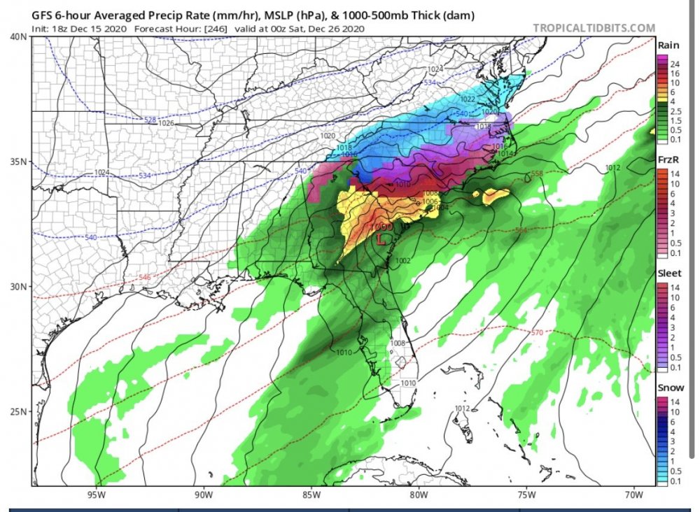
-
2020/2021 Fall/Winter Mountain thread
Sw NC weather replied to Met1985's topic in Southeastern States
Wow, down to 34 here now it’s falling quickly. -
2020/2021 Fall/Winter Mountain thread
Sw NC weather replied to Met1985's topic in Southeastern States
I agree I think it was a great approach from them. These cad setups are so tricky to forecast. Just go ahead and give everyone a heads up that’s there potential. I’m still shocked they put an advisory up for Macon. -
2020/2021 Fall/Winter Mountain thread
Sw NC weather replied to Met1985's topic in Southeastern States
Same here seen it too many times. Very rarely do we get ice down this way. Usually snow or rain. There’s still a slim possibility of snow happening something like the Canadian showed. -
2020/2021 Fall/Winter Mountain thread
Sw NC weather replied to Met1985's topic in Southeastern States
It was a fraction away from being a mountain wide snowstorm. 0.5-1” of precip with temps in the mid 30’s. Higher elevations are still able to cash in good this run. Maybe will see a trend to slightly colder. -
2020/2021 Fall/Winter Mountain thread
Sw NC weather replied to Met1985's topic in Southeastern States
Definitely an interesting week coming up. There’s lots of moving pieces, if we can tweak a few little things we’re set for a fun week of tracking.


