midatlanticweather
-
Posts
4,576 -
Joined
-
Last visited
Content Type
Profiles
Blogs
Forums
American Weather
Media Demo
Store
Gallery
Everything posted by midatlanticweather
-
Out here, just southwest of Purcellville, I am sitting at 1.58 inches of rain for the last 31 days! The storm two nights ago dumped almost an inch of rain less than 1 mile from my home! Yesterday, the storms literally split around me and I ended up with .04" . I submitted the information to the Climate office. Meanwhile, friends of mine in the eastern part of Loudoun saw 8+ inches of rain in June and over 3 inches the last week! I have brown grass and a dusty dry yard!
-
Seeing 92 on my weather station! Heat indexes bouncing between 95 and 96.. HOT one!
-
33.1 for a low in Purcellville, and the coldest windchill was 22 at about 6:15 am. Impressive for this time of year. Potential sprinkles ane flurries in the forecast. Brrr
-
Down to 39..cold Winds a blowing. Wind chills in the upper 20s.
-
38 here last night. Crazy to have so many 30s in the forecast over the next several days!
-
Wow. 37 here Colder Than expected.
-

2020 Mid-Atlantic Severe Weather - General Thread
midatlanticweather replied to Kmlwx's topic in Mid Atlantic
Not too exciting. Bit of wind and some quick heavy rain. Heard one thunderclap here in Purcellville. This is quickly moving on, but was not just a rain shower.. had winds in the upper 30s briefly. -
2020 Mid-Atlantic Severe Weather - General Thread
midatlanticweather replied to Kmlwx's topic in Mid Atlantic
Soupy out there for sure. Occasional sun in Purcellville with a temp hovering around 74 for a while. DP of 68 -
2020 Mid-Atlantic Severe Weather - General Thread
midatlanticweather replied to Kmlwx's topic in Mid Atlantic
-
2020 Mid-Atlantic Severe Weather - General Thread
midatlanticweather replied to Kmlwx's topic in Mid Atlantic
I just happened to read that warning and it was estimating winds to 80mph possible! WOW! -
2020 Mid-Atlantic Severe Weather - General Thread
midatlanticweather replied to Kmlwx's topic in Mid Atlantic
Wow! Glad they are ok! -
2020 Mid-Atlantic Severe Weather - General Thread
midatlanticweather replied to Kmlwx's topic in Mid Atlantic
Just a note! Eastern NC is lit! Wow! -
2020 Mid-Atlantic Severe Weather - General Thread
midatlanticweather replied to Kmlwx's topic in Mid Atlantic
LWX thoughts Potential still exists for a second round of showers and possible thunderstorms to develop in the 15Z-18Z time frame, but this isn`t completely certain it will happen. Hi-res models are in disagreement with convective coverage with the HRRR showing mainly shallow convection and the Hi-Res ARW and the NSSL WRF ARW showing scattered deep convection in the form of short lines or bowing segments. The 12Z IAD sounding showed two inversions with one from sfc to 850 mb and second one from 750 to 700 mb and corresponding high LFC or Level of Free Convection abv 700 mb. With best 3-hr pressure falls and height falls occurring over western and north central MD in the 15Z-18Z time frame, this is where I would expect the best chance of deep convective development rest of today. Regardless of convective coverage and intensity, strong gradient winds of 45 to 55 mph will occur outside of showers except greater than 57 mph in southern MD where 50kt have already been reported. The risk of convection will be winding down after 18Z and should be over by 21Z if not sooner. -
"Only" 0.99" so far out here in Purcellville. That extra heavy rain went east of me this morning. Lull for now as we await round two in a few hours. Stay safe all!
-
Flurries all over Loudoun currently... I have a few out here in Purcellville.
-
2020 Mid-Atlantic Severe Weather - General Thread
midatlanticweather replied to Kmlwx's topic in Mid Atlantic
Potential is definitely starting to show some focus. SPC highlighting Marginal next two days. HRRR going a bit crazy (notoriously).. We will see. Could be an interesting few days nonetheless. -
I would care more if we were tracking snow.
-
Well, maybe people aren't traveling as much.... Ya! Right!

-
70s Monday?
-
I have seen/read this story again and again this season...... it will disappear by early next week..
-
Thunder and lightning. Heavy rain off and on with showers. Winds kind of picked up too
-
February Medium/Long Range Discussion
midatlanticweather replied to WinterWxLuvr's topic in Mid Atlantic
Only in NC! -
February Medium/Long Range Discussion
midatlanticweather replied to WinterWxLuvr's topic in Mid Atlantic
For some 70s..maybe -
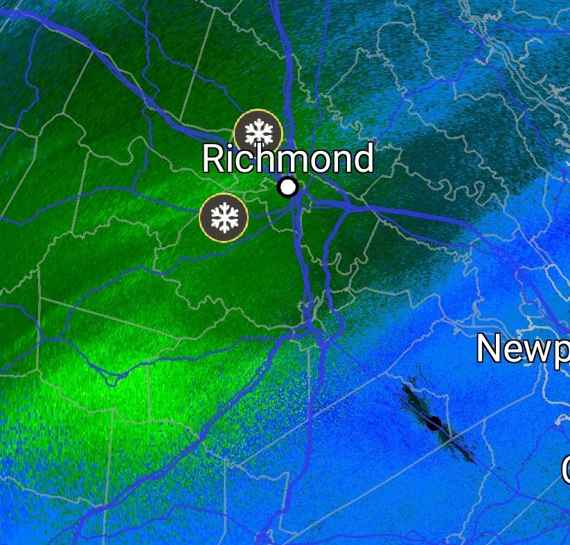
Richmond Metro/Hampton Roads Discussion
midatlanticweather replied to RIC Airport's topic in Mid Atlantic
Got some reports around Richmond
-
Guess snow south of us hurt in 2012 as well!