

midatlanticweather
-
Posts
4,576 -
Joined
-
Last visited
Content Type
Profiles
Blogs
Forums
American Weather
Media Demo
Store
Gallery
Everything posted by midatlanticweather
-

2021 Atlantic Hurricane Season Tracking Thread
midatlanticweather replied to WxWatcher007's topic in Mid Atlantic
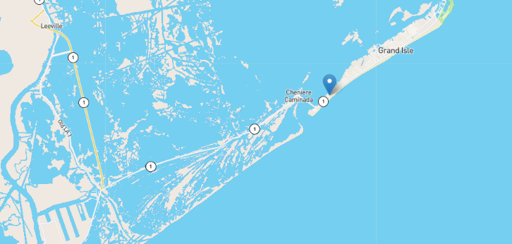
It will not make the eye proper, but will it rotate into the true eyewall? Close! Seems it will just about graze it. From what I can tell.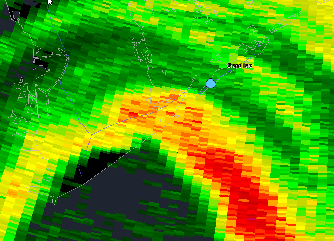
-
2021 Atlantic Hurricane Season Tracking Thread
midatlanticweather replied to WxWatcher007's topic in Mid Atlantic
Me too! It looks like the water is getting close to the Camera now! Will it hold!? -
2021 Mid-Atlantic Severe Weather - General Discussion
midatlanticweather replied to Kmlwx's topic in Mid Atlantic
Mesoscale Discussion 1628 NWS Storm Prediction Center Norman OK 1205 PM CDT Sat Aug 28 2021 Areas affected...South-Central Pennsylvania...Western Maryland...Eastern West Virginia...and Northern Virginia Concerning...Severe potential...Watch unlikely Valid 281705Z - 281900Z Probability of Watch Issuance...5 percent SUMMARY...Isolated damaging wind gusts possible with the strongest storms this afternoon. DISCUSSION...Visible satellite shows strong insolation this morning has given way to scattered convective development over the northern part of region. Surface temperatures have warmed into the mid 80s F amid rich low-level moisture (dew point temperatures in the upper 60s and low 70s F). This is yielding around 1000 J/kg of MLCAPE. With weak convective inhibition and continued heating/destabilization, additional pulse-like storms are expected to develop throughout the afternoon and gradually move southeastward with time. Weak flow throughout the atmosphere will limit storm organization, however, a few isolated damaging wind gusts will be possible with the strongest storms given at least marginal low-level lapse rates near 8 C/km that should develop, particularly over parts of northern Virginia and vicinity later this afternoon. Given the expectation for an isolated damaging wind threat, watch issuance is not expected. ..Karstens/Grams.. 08/28/2021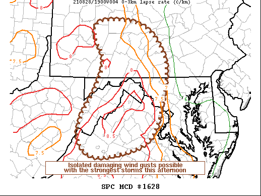
-
2021 Mid-Atlantic Severe Weather - General Discussion
midatlanticweather replied to Kmlwx's topic in Mid Atlantic
That storm in WV/MD looked interesting on one of the last scans. Not so much this scan.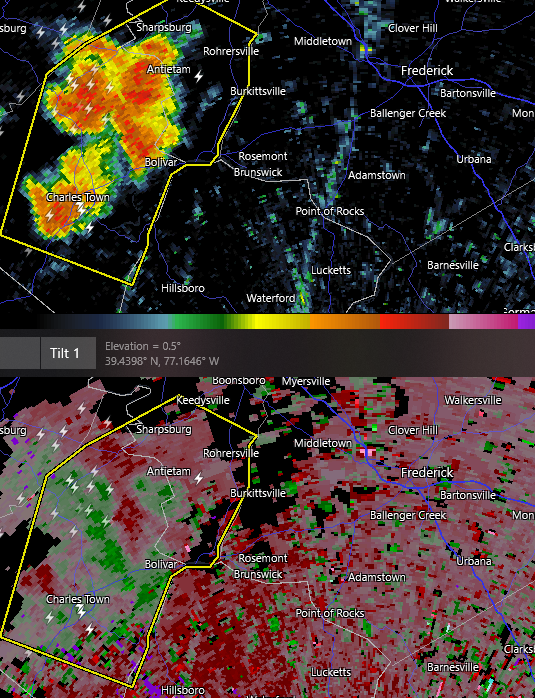
-
-
Amazing lightning show earlier, but MBY picked up a small 0.02 inches of precip! The scorched earth remains.
-
2021 Atlantic Hurricane Season Tracking Thread
midatlanticweather replied to WxWatcher007's topic in Mid Atlantic
I feel they have named worse! LOL! I think we have just enough as well. -
2021 Mid-Atlantic Severe Weather - General Discussion
midatlanticweather replied to Kmlwx's topic in Mid Atlantic
Morrisville/Goldvein - That thing is packing some punch! Wow!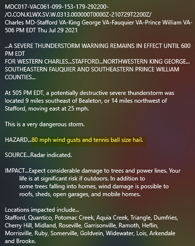
-
2021 Mid-Atlantic Severe Weather - General Discussion
midatlanticweather replied to Kmlwx's topic in Mid Atlantic
Loudoun is the same today. Some heavier stuff in the southern part of the county. -
2021 Mid-Atlantic Severe Weather - General Discussion
midatlanticweather replied to Kmlwx's topic in Mid Atlantic
Just S of Gaithersburg looks like it wants to hook..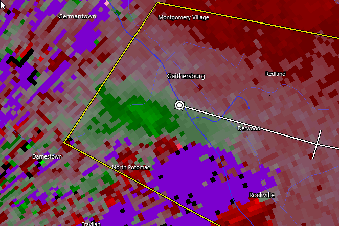
-
Trajectory for storm formation is not the best here in western Loudoun. DP 66 and at 88 degrees.
-
Thank you cool air outflow in Purcellville! Down to 81 now from 91 about an hour ago! If we get full sun again, I am sure the temps will pop right back up! VERY HUMID!
-
Loudoun Storm is no joke! But I am truly fringed here just west of Purcellville. Lights have flickered multiple times.
-
If you go outside and sneeze you may cause a cloud today! It is so steamy out there! 81 with a dp of 74 YUCK!
-
I am all messed up for the weekend. On the Fourth of July, where we celebrate the Independence from England, I am actually rooting for a model that is partially produced by the UK! It is Ironic! LOL!
-
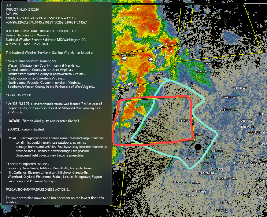
2021 Mid-Atlantic Severe Weather - General Discussion
midatlanticweather replied to Kmlwx's topic in Mid Atlantic
That second line is about to get Garrett County! I suspect it will weaken once in the area, but looks quite impressive now! -
2021 Mid-Atlantic Severe Weather - General Discussion
midatlanticweather replied to Kmlwx's topic in Mid Atlantic
That was really awesome. There is a ton of lightning in these storms. My son and I were filming but the rain was shielding most of the bolts. I know I got some! That was the best of the season so far out this way. -
2021 Mid-Atlantic Severe Weather - General Discussion
midatlanticweather replied to Kmlwx's topic in Mid Atlantic
Insane here in Purcellville!!! Best winds of the season -
2021 Mid-Atlantic Severe Weather - General Discussion
midatlanticweather replied to Kmlwx's topic in Mid Atlantic
Radarscope ha 2 inch hail indicated, Not sure what the ground truth is, but see some hail signatures in there. -
2021 Mid-Atlantic Severe Weather - General Discussion
midatlanticweather replied to Kmlwx's topic in Mid Atlantic
-
2021 Mid-Atlantic Severe Weather - General Discussion
midatlanticweather replied to Kmlwx's topic in Mid Atlantic
-
2021 Mid-Atlantic Severe Weather - General Discussion
midatlanticweather replied to Kmlwx's topic in Mid Atlantic
Yep! https://www.spc.noaa.gov/products/md/md1048.html -
2021 Mid-Atlantic Severe Weather - General Discussion
midatlanticweather replied to Kmlwx's topic in Mid Atlantic
Ya! -
53 this morning
-
SO AMAZING OUTSIDE! Temp 68 and DP of 59!

