midatlanticweather
-
Posts
4,576 -
Joined
-
Last visited
Content Type
Profiles
Blogs
Forums
American Weather
Media Demo
Store
Gallery
Everything posted by midatlanticweather
-
21.3 for the low! Coldest of the season yet! Love it!
-
As usual, the challenges with changing patterns and alignment on the right features at the right times is a game of luck! A more favorable pattern does not always equal a good outcome. We know it is not just the right pattern signals, but also the right items in the right places at the right time to get wintry weather. Also, in transition periods the models obviously get the details wrong even if they provide clues to what could happen. My take, (and I realize I ain't no pro!) is that we will miss out as the couple of opportunities that showed are no longer there, but, the pattern is slightly more favorable for a feature or system to do provide some flakes. So far, the few blips of potential have been lost on subsequent model runs and this slightly favorable period looks like a miss for anything in the region. The cold does not seem lasting (which I think we will have to get used to this winter, but especially this time of year) and the more zonal look of the long-range should be no surprise to anyone. Maybe something is being missed or not represented right on the models, but I think we remain waiting with a few small cold shots! Maybe we get lucky!
-
Need that low to the west to go away or transfer quick. My bet is it trends poorly due to that feature. If it disappears or is not there, maybe something can happen. Looks like a northeastern snow to me and mainly inland if it were to come true
-
Anyone seeing precip? Radar shows precipitation in northern Loudoun and Western Maryland
-
Gfs is going differently today. Colder looks for sure
-
GFS looks like it locks away the cold by the end. Zonal kiss of death for any hopes for cold intrusions. Sad Outlook
-

Winter 2021-2022 Digital Snow Thread
midatlanticweather replied to NorthArlington101's topic in Mid Atlantic
.thumb.png.e8a59272929c6fcb1bdcf1ffb4bd88d4.png)
-
Winter 2021-2022 Digital Snow Thread
midatlanticweather replied to NorthArlington101's topic in Mid Atlantic
.thumb.png.8d3a757a4dc4f65b193eeda3dcf2fe62.png)
-
GFS left nothing for me to be excited about. EURO threw a bone in there, but nothing seems super exciting. Kind of bored.
-
Mid-Atlantic winter 2021-22 snowfall contest
midatlanticweather replied to PrinceFrederickWx's topic in Mid Atlantic
BWI: 19" DCA: 10" IAD: 22" RIC: 6" Tiebreaker LYH): 7" -
CFS showing a crazy set up.. I know it is the CFS! LOL!
-
28.5 do far... probably will be the low! Great covering of frost everywhere! Love it!
-
Long-range, to me, looks less promising for any cold with legs to stand. Cold shot here then there and then a more zonal look to it. I am convinced this will be the plight of the winter with a somewhat promising look on a few model runs, then a revert to what is typical for La Nina.. I mean, this is the typical anyways!
-
38.3 here! Chilly nice night!
-
-
Winter 2021-2022 Digital Snow Thread
midatlanticweather replied to NorthArlington101's topic in Mid Atlantic
Lost digital snow overnight! Even seeing the snow hole -
47.1 for a high today. Coldest high temp of the fall.
-
Would be cool. Moderating it could be a huge challenge!
-
Winter 2021-2022 Digital Snow Thread
midatlanticweather replied to NorthArlington101's topic in Mid Atlantic
-
The Thursday system seems less and less exciting or even possible. Is this short-range stuff by now.. Probably.
-
6Z GFS with a SW VA Jackpot! You really think the snow will not cross into NC? LOL! (NC - NO SNOW FOR YOU!)
-
May be banter, but this video cracks me up! https://fb.watch/8-DeqVvhG3/
-
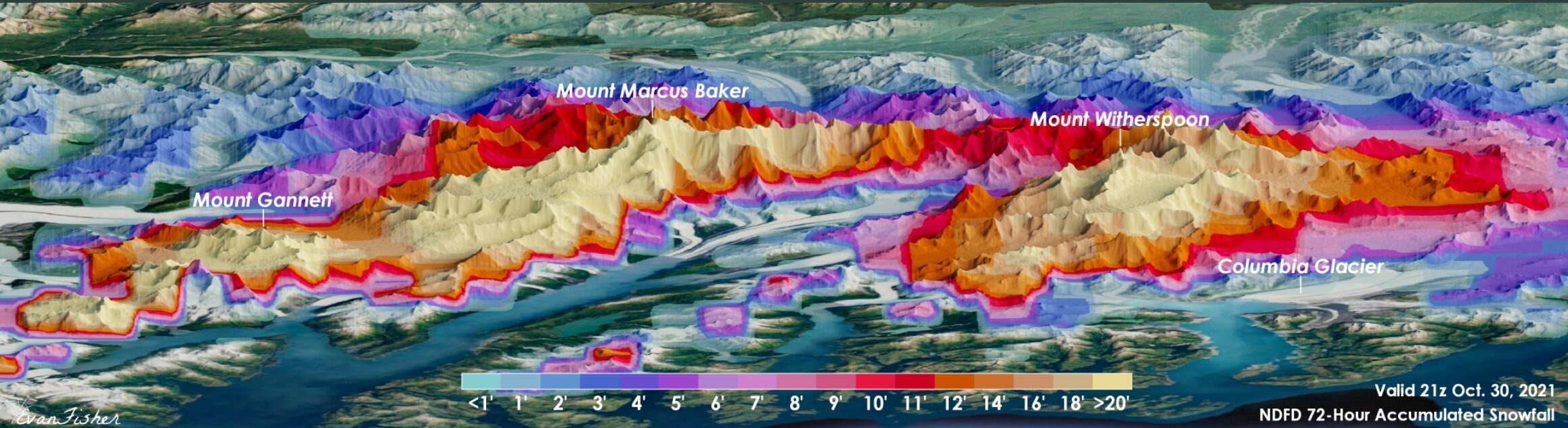
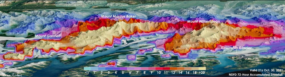
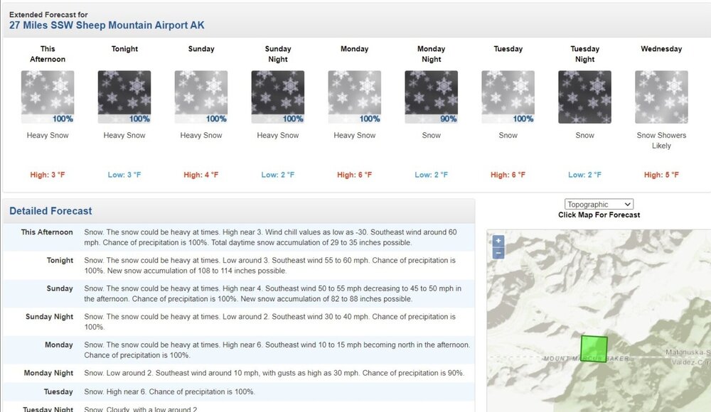
Alaska and snow!!! That map legend is in feet!
-
Started seeing the same yesterday. We will see if that continues. Seems possible in La Nina and the fact it has been a big player this fall.
-


.png.183f4400182d49a777aee1c73d94f077.png)

.png.6b661dcb9adf08cff2dddd768067e9f0.png)