midatlanticweather
-
Posts
4,587 -
Joined
-
Last visited
Content Type
Profiles
Blogs
Forums
American Weather
Media Demo
Store
Gallery
Everything posted by midatlanticweather
-

2022 Atlantic Hurricane Season Tracking Thread
midatlanticweather replied to WxWatcher007's topic in Mid Atlantic
-
Feels soupy for sure! I almost feel I could create a localized cell if I open my air conditioned home and cause condensation from the temp differential! That being said, I see the puffs now on the satellite and the isolated cells so we must have hit critical temp points to start some action. That looks especially true for any areas that were really clear for a bit and likely hottest. 86 with a DP of 72 here in Purcellville. The air is thick!
-
2022 Mid-Atlantic Severe Wx Thread (General Discussion Etc)
midatlanticweather replied to Kmlwx's topic in Mid Atlantic
BULLETIN - EAS ACTIVATION REQUESTED Tornado Warning National Weather Service Mount Holly NJ 620 PM EDT Tue Jul 5 2022 The National Weather Service in Mount Holly NJ has issued a * Tornado Warning for... West central Talbot County in eastern Maryland... Southwestern Queen Anne's County in northeastern Maryland... * Until 700 PM EDT. * At 619 PM EDT, a severe thunderstorm capable of producing a tornado was located over Kent Point, or near Shady Side, moving east at 20 mph. HAZARD...Tornado. SOURCE...Radar indicated rotation. IMPACT...Flying debris will be dangerous to those caught without shelter. Mobile homes will be damaged or destroyed. Damage to roofs, windows, and vehicles will occur. Tree damage is likely. * Locations impacted include... Talbot, Romancoke and Tilghman Island. N -
2022 Mid-Atlantic Severe Wx Thread (General Discussion Etc)
midatlanticweather replied to Kmlwx's topic in Mid Atlantic
TORNADO WARNING Tornado: OBSERVEDHail: <.75IN ...A TORNADO WARNING REMAINS IN EFFECT UNTIL 430 PM EDT FOR SOUTHEASTERN MIDDLESEX AND SOUTHEASTERN LANCASTER COUNTIES... At 415 PM EDT, a confirmed tornado was located near White Stone, moving southeast at 25 mph. HAZARD...Damaging tornado. SOURCE...Weather spotters confirmed tornado. IMPACT...Flying debris will be dangerous to those caught without shelter. Mobile homes will be damaged or destroyed. Damage to roofs, windows, and vehicles will occur. Tree damage is likely. This tornado will be near... White Stone around 420 PM EDT. Other locations impacted by this tornadic thunderstorm include Hardyville, Weems, Christ Church, Wake, Greys Point and Wilton. Close -
2022 Mid-Atlantic Severe Wx Thread (General Discussion Etc)
midatlanticweather replied to Kmlwx's topic in Mid Atlantic
Tor down SE VA BULLETIN - EAS ACTIVATION REQUESTED Tornado Warning National Weather Service Wakefield VA 335 PM EDT Tue Jul 5 2022 The National Weather Service in Wakefield has issued a * Tornado Warning for... Northwestern Middlesex County in eastern Virginia... South central Richmond County in east central Virginia... Southeastern Essex County in east central Virginia... Western Lancaster County in eastern Virginia... * Until 400 PM EDT. * At 334 PM EDT, a severe thunderstorm capable of producing a tornado was located near Morattico, or near Robley, moving east southeast at 25 mph. HAZARD...Tornado. SOURCE...Radar indicated rotation. IMPACT...Flying debris will be dangerous to those caught without shelter. Mobile homes will be damaged or destroyed. Damage to roofs, windows, and vehicles will occur. Tree damage is likely. -
2022 Mid-Atlantic Severe Wx Thread (General Discussion Etc)
midatlanticweather replied to Kmlwx's topic in Mid Atlantic
Here is that boundary in Loudoun
-
2022 Mid-Atlantic Severe Wx Thread (General Discussion Etc)
midatlanticweather replied to Kmlwx's topic in Mid Atlantic
-
2022 Mid-Atlantic Severe Wx Thread (General Discussion Etc)
midatlanticweather replied to Kmlwx's topic in Mid Atlantic
https://www.spc.noaa.gov/products/md/md1314.html -
-
2022 Mid-Atlantic Severe Wx Thread (General Discussion Etc)
midatlanticweather replied to Kmlwx's topic in Mid Atlantic
NAM looked interesting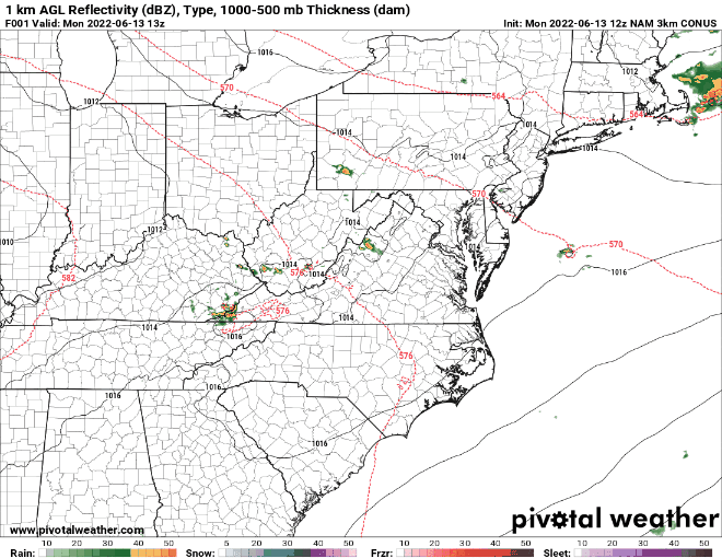
-
GFS Ridge looks terrible next week! Hoping things do not get this bad, but I have felt we have been lucky so far and that the luck will run out for later June and July.
-
2022 Mid-Atlantic Severe Wx Thread (General Discussion Etc)
midatlanticweather replied to Kmlwx's topic in Mid Atlantic
-
2022 Mid-Atlantic Severe Wx Thread (General Discussion Etc)
midatlanticweather replied to Kmlwx's topic in Mid Atlantic
Several just east of me were saying they thought they had a tornado. I was hoping to look at the radar at the time, but was unable. I do not know if the NWS was going to take a look or not. BTW, I was pretty sure that is what I was seeing, but I was not going to just say it was without others agreeing. Anyways, I went right under it, but was in a car and not a good spot to photograph it. This was exactly what I saw as well. -
2022 Mid-Atlantic Severe Wx Thread (General Discussion Etc)
midatlanticweather replied to Kmlwx's topic in Mid Atlantic
I know this is days late! This was what the storms that came through and caused the wind damage and hail last week looked like as they were going through Purcellville. I did not take this photo and take no credit for them (Here is the original https://www.facebook.com/photo?fbid=3196421617280200&set=pcb.2254113818069568) but I saw the same thing! Looked very impressive! What do you all think these are? Reminds me of a rotating storm with a wall cloud. -
My weather station decided to screw up and measured a -40F last night! That is kind of messing with my stats for June so far! LOL! I was outside late last evening and it was awesome and nicely cool!
-
2022 Mid-Atlantic Severe Wx Thread (General Discussion Etc)
midatlanticweather replied to Kmlwx's topic in Mid Atlantic
Does anyone have radars in the Purcellville to Leesburg area yesterday when the severe was coming through? A lot of damage from wind and I swear I saw a wall cloud while driving into Leesburg (my son has some video I need to review). A lot of trees down and not all in one direction in the area. I wonder if NWS will take a look. A friend of ours swears a tornado went through their property, but I have not been able to visit. This was the same one that then hailed on Leesburg. Thanks! -
2022 Mid-Atlantic Severe Wx Thread (General Discussion Etc)
midatlanticweather replied to Kmlwx's topic in Mid Atlantic
It was good in Purcellville at the start with some serious heavy rain too. Did not last too long but picked up 0.3 inches in about 10 minutes -
2022 Mid-Atlantic Severe Wx Thread (General Discussion Etc)
midatlanticweather replied to Kmlwx's topic in Mid Atlantic
Incoming in Purcellville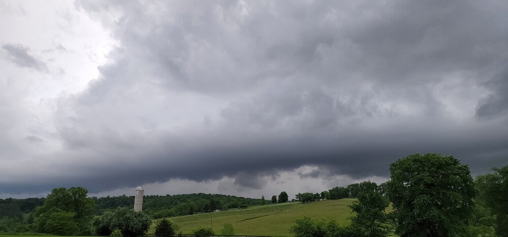
-
2022 Mid-Atlantic Severe Wx Thread (General Discussion Etc)
midatlanticweather replied to Kmlwx's topic in Mid Atlantic
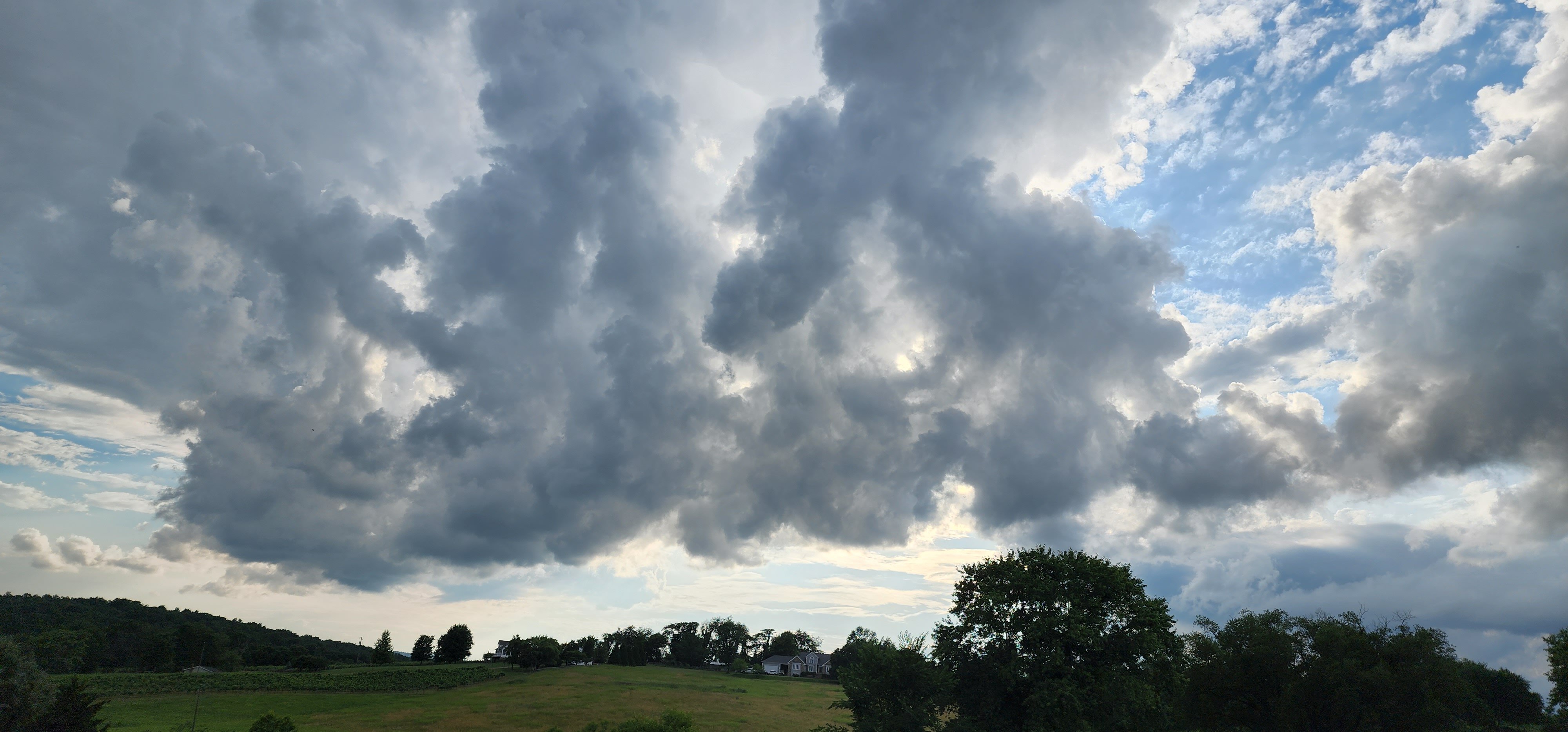
This looks like something! SW VA - Just noting the supercell look on these storms.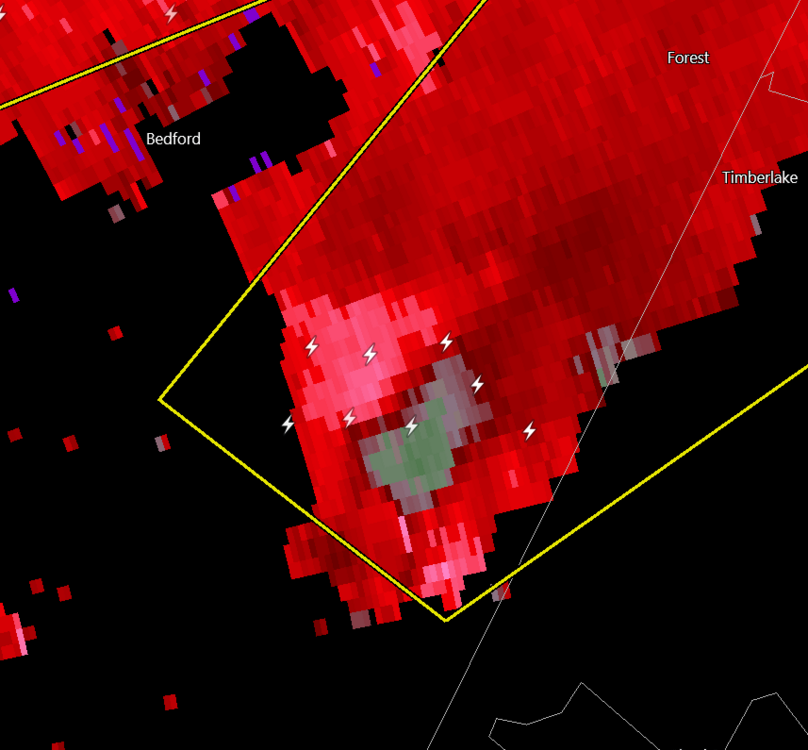
-
2022 Mid-Atlantic Severe Wx Thread (General Discussion Etc)
midatlanticweather replied to Kmlwx's topic in Mid Atlantic
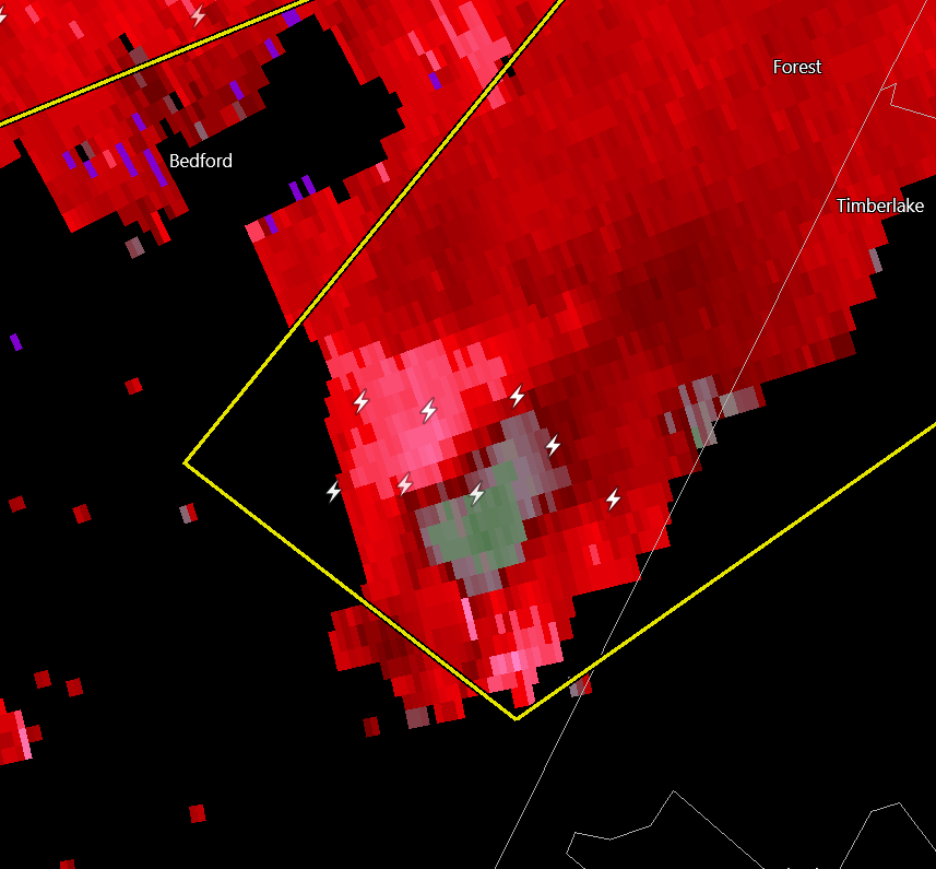
Man, that cell south of Bedford looks like it is trying to spin up.. we will see. Not good. -
2022 Mid-Atlantic Severe Wx Thread (General Discussion Etc)
midatlanticweather replied to Kmlwx's topic in Mid Atlantic
Getting peaks of sun in Purcellville. Air feels thick with temps staying in the low 70s. Better clearing is heading this way. -
2022 Mid-Atlantic Severe Wx Thread (General Discussion Etc)
midatlanticweather replied to Kmlwx's topic in Mid Atlantic
Nice downpour but little wind here in Purcellville. We have had almost 0.4 inches of rain in the last 15 minutes so it is a soaker! -
I was about to come over here and mention the same. Let's hope the GFS is messed up! It kind of looks unsettled on most of that run for the east.
-
Getting the feeling we are going to be wetter from this southern system than what we first thought. Trending north a bit. We shall see!
-
0.86 yesterday. Nice lightning and Thunder - a double rainbow... was good. The lawn was mowed 30 minutes before the unload and looks so nice today!