midatlanticweather
-
Posts
4,928 -
Joined
-
Last visited
Content Type
Profiles
Blogs
Forums
American Weather
Media Demo
Store
Gallery
Everything posted by midatlanticweather
-
A bit warm! LOL! But nice!
-
Best day of the year so far. Stayed outside from 10am to sundown.
-
1.57 yesterday. I can hear the grass growing
-
1.44 inches today! Much needed rain!
-
I feel like i am in the deform band. 0.92 so far and moderate to heavy rain at the moment in Purcellville
-
31.2 degrees early this morning! Very chilly morning! Looking like an amazing day, up to 55 now!
-
I have picked up a total of 0.02" in the last 7 days in Purcellville, VA. Need rain!
-
I was thinking this exact thing this year! The bathwater of the Atlantic and Gulf can be great for juicy storms, but also make us too warm when it comes to winters. I know he could find snow in a Thunderstorm in the middle of summer if he tried hard enough, but Joe Bastardi often linked increased hurricane activity to better east coast winter storms. I have no idea if there is a correlation, but I was thinking this last year we needed something to cool it down! Add the unfrozen Great Lakes, and it just did not help at all.
-

2023 Mid-Atlantic Severe Wx Thread (General Discussion)
midatlanticweather replied to Kmlwx's topic in Mid Atlantic
Interesting -
2023 Mid-Atlantic Severe Wx Thread (General Discussion)
midatlanticweather replied to Kmlwx's topic in Mid Atlantic
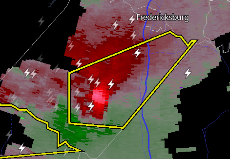
That storm south of Fredericksburg has my attention!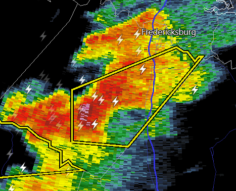
- 2,785 replies
-
- 1
-

-
- severe
- thunderstorms
- (and 3 more)
-
2023 Mid-Atlantic Severe Wx Thread (General Discussion)
midatlanticweather replied to Kmlwx's topic in Mid Atlantic
-
2023 Mid-Atlantic Severe Wx Thread (General Discussion)
midatlanticweather replied to Kmlwx's topic in Mid Atlantic
- 2,785 replies
-
- 4
-
-
- severe
- thunderstorms
- (and 3 more)
-
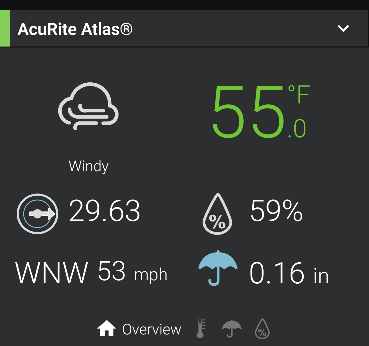
Wow, checked and I managed 29.5 degrees for a low this morning. As far as gusts. I know that we managed at least 20 mph more than what I was able to get on my weather station. The weather station measured a 53mph sustained wind before the power went out and 5 telephone poles were toppled about a half mile from me. That was one of the better wind events since the one back in 2018.
-
Now that is impressive for my lame weather station. 53 mph! Gusts are higher here in Purcellville
-
2023 Mid-Atlantic Severe Wx Thread (General Discussion)
midatlanticweather replied to Kmlwx's topic in Mid Atlantic
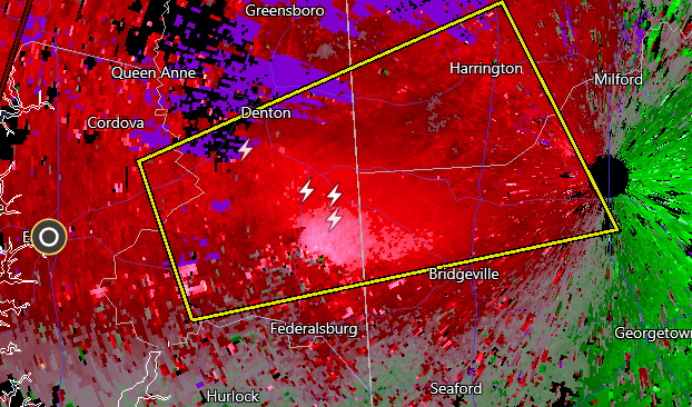
Latest scan, after the radar shadow, still looks like a good couplet.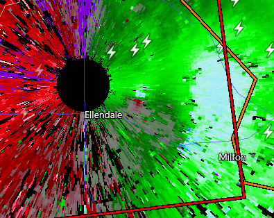
-
2023 Mid-Atlantic Severe Wx Thread (General Discussion)
midatlanticweather replied to Kmlwx's topic in Mid Atlantic
Just coming to say the same!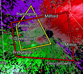
- 2,785 replies
-
- 1
-
-
- severe
- thunderstorms
- (and 3 more)
-
2023 Mid-Atlantic Severe Wx Thread (General Discussion)
midatlanticweather replied to Kmlwx's topic in Mid Atlantic
And- We got a warning!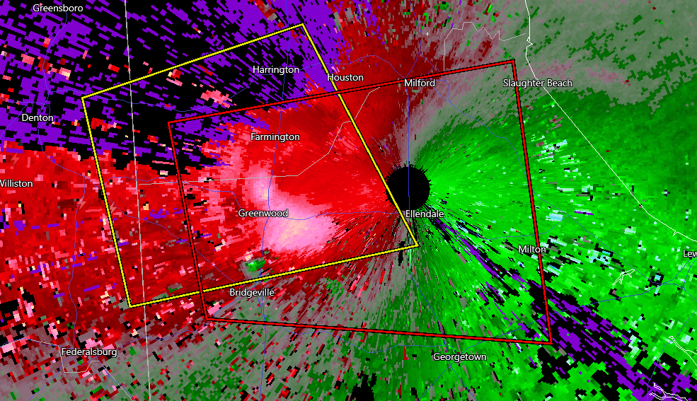
-
2023 Mid-Atlantic Severe Wx Thread (General Discussion)
midatlanticweather replied to Kmlwx's topic in Mid Atlantic
That storm has the look!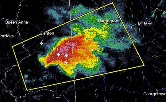
- 2,785 replies
-
- 1
-
-
- severe
- thunderstorms
- (and 3 more)
-
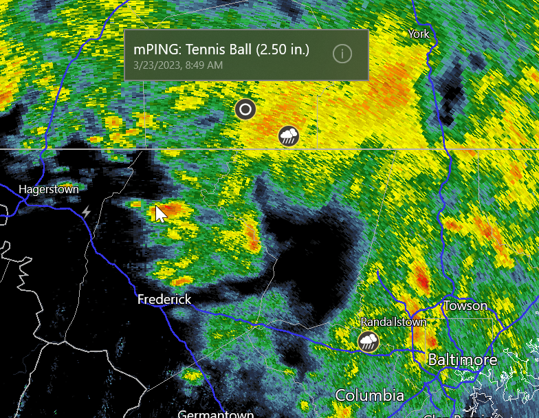
BULLETIN - IMMEDIATE BROADCAST REQUESTED Severe Thunderstorm Warning National Weather Service Baltimore MD/Washington DC 1124 PM EDT Thu Mar 23 2023 The National Weather Service in Sterling Virginia has issued a * Severe Thunderstorm Warning for... Southeastern Washington County in north central Maryland... Northwestern Montgomery County in central Maryland... Southwestern Frederick County in north central Maryland... Northeastern Loudoun County in northern Virginia... Northeastern Jefferson County in the Panhandle of West Virginia... * Until midnight EDT. * At 1124 PM EDT, a severe thunderstorm was located near Brunswick, or 9 miles southeast of Shepherdstown, moving southeast at 50 mph. HAZARD...60 mph wind gusts and quarter size hail. SOURCE...Radar indicated. IMPACT...Damaging winds will cause some trees and large branches to fall. This could injure those outdoors, as well as damage homes and vehicles. Roadways may become blocked by downed trees. Localized power outages are possible. Unsecured light objects may become projectiles. * Locations impacted include... Germantown, Frederick, Damascus, Poolesville, Ballenger Creek, Brunswick, Braddock Heights, Harpers Ferry, Boyds, Point Of Rocks, Clarksburg, Darnestown, Adamstown, Jefferson, Lovettsville, Buckeystown, Rosemont, Rohrersville, Barnesville and Burkittsville.
-
I doubt that!
-
3/10 and beyond... all the waves threats
midatlanticweather replied to mappy's topic in Mid Atlantic
Not for GPT4 -
3/10 and beyond... all the waves threats
midatlanticweather replied to mappy's topic in Mid Atlantic
I decided to start following some of the snow plow people on YouTube and can finally understand too much snow. It is a foreign concept to me until I see what these guys are doing every day! Incredible -
3/10 and beyond... all the waves threats
midatlanticweather replied to mappy's topic in Mid Atlantic
Probably not favorable though! Still too progressive and the Pacific just never wants to cooporate. -
Nice snow. Little whitening of mulch. The flakes have some great structure so they look really cool. 34 degrees I. Purcellville
-
3/10 and beyond... all the waves threats
midatlanticweather replied to mappy's topic in Mid Atlantic
I threw in the towel! The larger swollen lady has sung, the fork tested winter, and it is done. I will not trust Lucy again this season. Looks like a cool couple of weeks, but snow chances are likely done!