midatlanticweather
-
Posts
4,576 -
Joined
-
Last visited
Content Type
Profiles
Blogs
Forums
American Weather
Media Demo
Store
Gallery
Everything posted by midatlanticweather
-
Perfect weather here today! 64 degrees
-
Euro seems to be showing a severe threat for Saturday. Maybe some more knowledgeable can comment.
-
This is a crazy animation!
-
Seems GFS is 1 to 2 inches and Euro 1 to 3 inches. NWS is much more robust for the area with 2 to 5 inches in the area. I am pretty sure 1 to 3 inches with some higher, especially south, seems more likely to me. I see the ICON, but I do not trust that much! We shall see, but a southern push seems possible!
-
-
On subject! Euro has Ian off the FL Coast
-
Wegman's Carrot Cake is insane! I agree here!
-
-
Wonder if the recurve will get us another cold shot in a few weeks? Kalup
-
This is all I think of when I hear Fall Foliage now! LOL
-
Ain't nothing wrong with it! It doesn't hurt nobody! (from a Christmas Light and decoration Nut!) Showers and breezy in Purcellville - need to keep it on topic!
-
Every weather weenie on twitter: Not a forecast - but freak out over this The forecast is not clear - But this looks devastating The range of options is enormous - But look at this Cat 4 hitting Florida. In the short range, for real, Nova Scotia looks to get rocked.
-

October-September Long range
midatlanticweather replied to StormchaserChuck!'s topic in Mid Atlantic
Interesting string of tweets -
I like what the models are selling for next weekend! 40s for some (maybe 30s for the mountains) for lows- Probably overdone and we know it may not hold, but cool!
-
2022 Atlantic Hurricane Season Tracking Thread
midatlanticweather replied to WxWatcher007's topic in Mid Atlantic
GFS Long range! LOL! -
2022 Mid-Atlantic Severe Wx Thread (General Discussion Etc)
midatlanticweather replied to Kmlwx's topic in Mid Atlantic
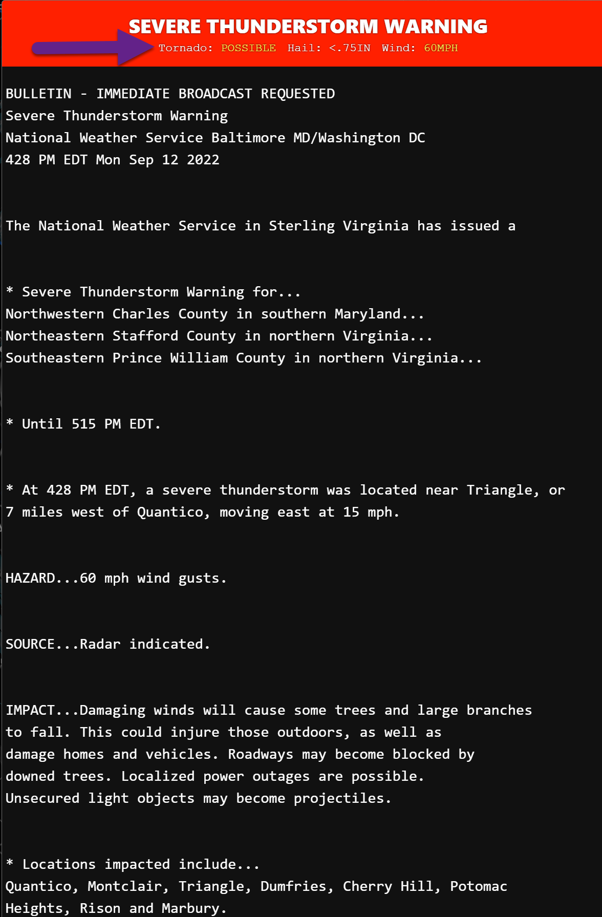
BULLETIN - EAS ACTIVATION REQUESTED Tornado Warning National Weather Service Baltimore MD/Washington DC 452 PM EDT Mon Sep 12 2022 The National Weather Service in Sterling Virginia has issued a * Tornado Warning for... Northwestern Charles County in southern Maryland... Southeastern Fairfax County in northern Virginia... Southeastern Prince William County in northern Virginia... * Until 515 PM EDT. * At 451 PM EDT, a severe thunderstorm capable of producing a tornado was located over Dumfries, or near Quantico, moving east at 15 mph. HAZARD...Tornado. SOURCE...Radar indicated rotation. IMPACT...For those in the direct path of a tornado touchdown, flying debris will be dangerous to those caught without shelter. Damage to roofs, siding, and windows may occur. Mobile homes may be damaged or destroyed. Tree damage is likely. * This tornadic thunderstorm will remain over mainly rural areas of northwestern Charles, southeastern Fairfax and southeastern Prince William Counties, including the following locations... Cherry Hill and Mason Neck. -
2022 Mid-Atlantic Severe Wx Thread (General Discussion Etc)
midatlanticweather replied to Kmlwx's topic in Mid Atlantic
That Dale City cell - Thunderstorm warned. Looks like it is rotating a bit.
-
Looks like I got about .35" and not much on radar to the west! I seem to have lucked out based on my roof situation. I do see more showers.. so I am cautiously optimistic out here in Purcellville.
-
2022 Mid-Atlantic Severe Wx Thread (General Discussion Etc)
midatlanticweather replied to Kmlwx's topic in Mid Atlantic
Here is the video from down in Culpepper. -
2022 Mid-Atlantic Severe Wx Thread (General Discussion Etc)
midatlanticweather replied to Kmlwx's topic in Mid Atlantic
I noticed the highest winds look just north of Stone Ridge. It just has that interesting look and earlier seemed to have some rotation showing. Not certain now as the proximity of radar seems to be showing uniformity. I checked the smaller radar but that does not seem to show anything. Just some winds and rain now. -
2022 Mid-Atlantic Severe Wx Thread (General Discussion Etc)
midatlanticweather replied to Kmlwx's topic in Mid Atlantic
SE Loudoun storm looks Interesting! Thoughts? -
2022 Mid-Atlantic Severe Wx Thread (General Discussion Etc)
midatlanticweather replied to Kmlwx's topic in Mid Atlantic
-
-
That storm near Culpepper looks interesting!
-
Hoping I get missed! Have found that I have a roof leaking after a recent downpour. Need that handled first... NAM on board with locally heavy precipitation. Location will make all the difference!