midatlanticweather
-
Posts
4,587 -
Joined
-
Last visited
Content Type
Profiles
Blogs
Forums
American Weather
Media Demo
Store
Gallery
Everything posted by midatlanticweather
-
The storm after the storm (and after that storm... and after that storm.. and then winter 2023 - 2024 on December 5.. and )
-

Winter Storm Zoom Chats Interest???
midatlanticweather replied to psuhoffman's topic in Mid Atlantic
Bumping! What do you think about Tuesday Evening 0z run make sense? If trends continue? @psuhoffman -
That upper-level map is a Beaut!
-
But there was blue finally!
-
Man! That GEFS is like a picture frame of what we need for snow! Let's see continued improvement and one of the OPS runs is gonna spit out a big dog! Just hope we get the full benefits!
-
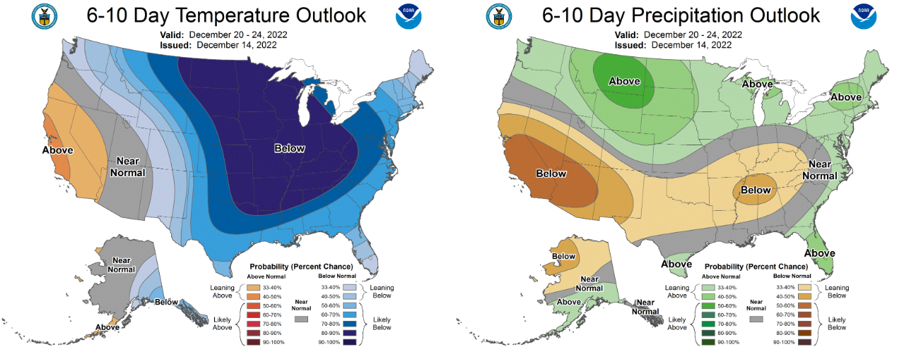
CPC also says more things keep pointing favorably! Best set of maps I have seen in very long time:

-
37/21 in Purcellville
-
Oh wow! Some very close calls for Christmas. Few better adjustments and Bing Crosby may start singing! If we get a big snow Amwx is "gonna find the jolliest bunch of a$$holes this side of the nuthouse." My banter shall end.
-
Maybe check that resource! - I am going to now.
-
12z NAM looks quite a bit more icy. Maybe warnings expand a bit? I dunno.
-
Hit 19 at about 3am. Strange spike to 25 at 6am but back to 20 currently.
-
Flash Freeze?! LOL! Dang, that is goanna be a Christmas Decoration obliteration due to winds!! YIKES!
-
This looks like we repeat next week! Some slop to rain then the ice box. (According to the GFS OP) Perfect. LOL! NOT!
-
Good summary by Peter
-
Someone left their heat on and the door open in far northern Loudoun and the models see it!
-
I think sleety accumulations will be a small amount until you get near the PA/MD Border and far NW - I think we all see a sleety start that turns to rain in less than an hour. The amounts of frozen actually accreting will be a question. I have added nothing more than saying I agree with the Mets here that this is advisory until you get to the mountain valleys! And no one wants a bad ice storm, especially with the winds forecast! NO THANKS! I would take sleet instead of Freezing Rain in a heartbeat. Anyways, I would not be surprised if folks west of Rt 15 get into a watch this afternoon and get moved to an advisory based on the worst-case scenario and awareness. Mountain areas go to warnings tomorrow! But who am I, but a weenie!
-
Time for your famous - "We are too far north, south or east for good snows" quote! (Maybe the east is not in that!)
-
GFS putting down some ice storm totals! I know it is way overdone on Pivotal!
-
Two more runs shift south and east and boom! Bob's your uncle! (OK - I watched Spirited! SO GOOD) I am not talking to you @Bob Chill - unless you can make it snow!
-
Well, I would take that run for sure! LOL! New runs every run!
-
Gonna bring the blue crush if this keeps up. Snow in the south and bitter cold here. Is that what you are thinking?
-
Probably to trend worse. Terrible setup. The trend was a little less terrible but we need leaps better and the changes from here on out are likely to be warmer and to the north. I hope I am somehow wrong. This has always been unlikely and continues to show us how it can fail.
-
-
What happened to the system!

-
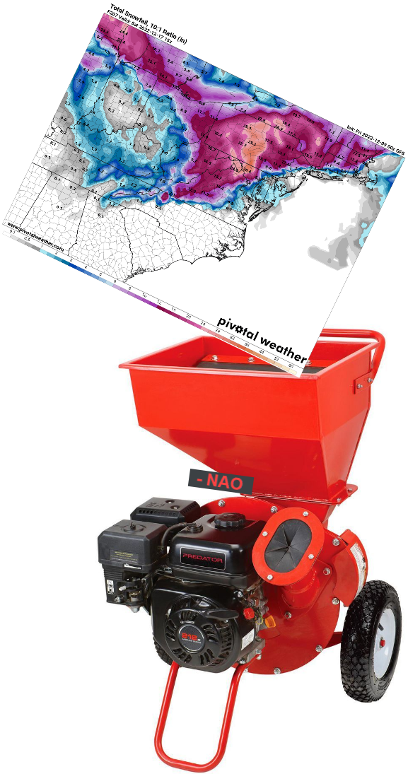
This board is in true form!! It is what I love! The Ensemble looked pretty good. Nice to see. But the shredder has been very capable this fall of taking 1 to 3 inch rain storms and giving me a quarter inch as we got close. That will continue the way it looks