midatlanticweather
-
Posts
4,573 -
Joined
-
Last visited
Content Type
Profiles
Blogs
Forums
American Weather
Media Demo
Store
Gallery
Everything posted by midatlanticweather
-
The cell near The Plains and west of Haymarket has my attention
-
Mesoscale Discussion 1021 NWS Storm Prediction Center Norman OK 0349 PM CDT Mon May 27 2024 Areas affected...portions of eastern North Carolina and eastern Virginia Concerning...Tornado Watch 335... Valid 272049Z - 272215Z The severe weather threat for Tornado Watch 335 continues. SUMMARY...The severe threat continues across Tornado Watch 335. Large hail and damaging gusts remain a concern. The best chance for tornadoes would be closer to the coastline ahead of ongoing storms. DISCUSSION...Multicells and transient supercells persist across northeastern NC and are moving northeast toward southeast VA. At the moment, these are the most robust storms across eastern NC/VA, though an increase in thunderstorm coverage is possible later this afternoon. Given widespread 1000-3000 J/kg MLCAPE and 40+ kts of effective bulk shear, most thunderstorms should maintain a multicellular or transient supercell mode through the afternoon. While a tornado or two cannot be ruled out anywhere across Tornado Watch 335 in eastern NC/VA, the best chance for tornadoes appears to be far southeast VA/northeast NC closer to the coast, where backed low-level winds are contributing to slightly larger low-level hodographs.
- 1,696 replies
-
- 1
-

-
- severe
- thunderstorms
- (and 5 more)
-
-
Others called out that there was a brief debris ball on CC. I dunno! we will see.
-
CC was interesting for a moment, but I think that was a false signal.
- 1,696 replies
-
- 1
-
-
- severe
- thunderstorms
- (and 5 more)
-
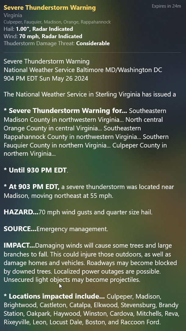
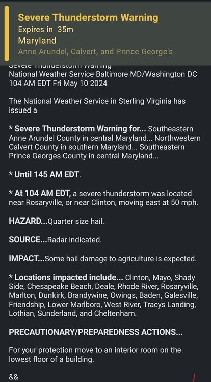
A huge polygon for the entire line is now issued. BULLETIN - IMMEDIATE BROADCAST REQUESTED Severe Thunderstorm Warning National Weather Service Baltimore MD/Washington DC 905 PM EDT Sun May 26 2024 The National Weather Service in Sterling Virginia has issued a * Severe Thunderstorm Warning for... Northwestern Washington County in north central Maryland... Northeastern Allegany County in western Maryland... Southwestern Stafford County in northern Virginia... Southwestern Loudoun County in northern Virginia... Northeastern Shenandoah County in northwestern Virginia... Frederick County in northwestern Virginia... Orange County in central Virginia... The City of Fredericksburg in central Virginia... Rappahannock County in northwestern Virginia... Central Fauquier County in northern Virginia... Culpeper County in northern Virginia... Central Madison County in northwestern Virginia... Warren County in northwestern Virginia... Western Clarke County in northwestern Virginia... Northeastern Page County in northwestern Virginia... The City of Winchester in northwestern Virginia... Spotsylvania County in central Virginia... West central Jefferson County in the Panhandle of West Virginia... Morgan County in the Panhandle of West Virginia... Northeastern Mineral County in eastern West Virginia... Northeastern Hardy County in eastern West Virginia... Western Berkeley County in the Panhandle of West Virginia... Hampshire County in eastern West Virginia... * Until 1000 PM EDT. * At 905 PM EDT, severe thunderstorms were located along a line extending from near La Vale to 6 miles south of Romney to 6 miles north of Basye-Bryce Mountain to near Mount Jackson to 6 miles north of Boswells Tavern, moving east at 35 mph. HAZARD...60 mph wind gusts. SOURCE...Radar indicated. IMPACT...Damaging winds will cause some trees and large branches to fall. This could injure those outdoors, as well as damage homes and vehicles. Roadways may become blocked by downed trees. Localized power outages are possible. Unsecured light objects may become projectiles. * Locations impacted include... Winchester, Fredericksburg, Cumberland, Culpeper, Front Royal, Warrenton, Strasburg, Woodstock, Orange, Hancock, Paw Paw, Madison, Millwood Pike, Luray, Bealeton, Inwood, Stephens City, Fort Ashby, Berkeley Springs, and Sperryville. PRECAUTIONARY/PREPAREDNESS ACTIONS... For your protection move to an interior room on the lowest floor of a building.
-
Considerable just issued!

-
- 1,696 replies
-
- 1
-
-
- severe
- thunderstorms
- (and 5 more)
-
Crazy warning polygon

-
Watch is up

-
Severe close by
- 1,696 replies
-
- 1
-
-
- severe
- thunderstorms
- (and 5 more)
-
So we were downgraded to Marginal risk. Seems right based on all the trends.
-
89 here in Purcellville for the high today. Stinking hot!
-

April Medium/ Long Range Discussion
midatlanticweather replied to Weather Will's topic in Mid Atlantic
-
- 1,696 replies
-
- 1
-
-
- severe
- thunderstorms
- (and 5 more)
-
Nadocast https://x.com/nadocast/status/1778082581541752878
- 1,696 replies
-
- 2
-
-
- severe
- thunderstorms
- (and 5 more)
-
Lots of graupel/snow here in Purcellville. Temp dropped to 38!
-
66 degrees!! It was almost 70 an hour ago. Low was 61! Hot for this time of year!
-
Late Feb/March Medium/Long Range Discussion
midatlanticweather replied to WinterWxLuvr's topic in Mid Atlantic
Good news is that the European computing power was increased and now runs at least an hour sooner -
Late Feb/March Medium/Long Range Discussion
midatlanticweather replied to WinterWxLuvr's topic in Mid Atlantic

-
With all the squabbling going on I thought I would share these things somewhere: Things I think we know and should live by: * You cannot jinx with things by what you say or do. It is funny to see the superstitious amongst people who are science minded.. and it can be enjoyable! * Your gut feeling has nothing to do with reality * Saying absolutes in science is not scientific. We make educated guesses and test it over and over again. * Question everything, make good conclusions based on research, but be open to well thought out challenges * Even when being challenged by what seems stupid, and it seems ridiculous, do not let emotion override sound research. and always welcome challenges * Learn from everything.. that means examine it after it happens! Live, learn, grow!
-
I wish I had better understanding of the dynamics involved. Many times, we had bad luck! At times the temps were a few degrees off. The weird way the Nino activity worked this year was reminiscent of Nina at times. When we were really wet, the cold was not cold enough or not available at all. Lack of Negative NAO combined with the PNA pattern were obvious issues. I mean we know the reality of what transpired, but, as Bob noted, maybe we just got unlucky. If we had a few big systems hit when it was cold, it would have been good. NA snow cover shows it was not just a local issue! When the continent is low on snow cover, we should know we are going to be even more unlucky. I think there were many compounding issues. The additional obvious trend of the boundary being very warm the last several years is no help! I think the warm Atlantic and even the great lakes do not help us when we are marginal, but that maybe just chicken and egg discussion. What also sucked was the poor model outlooks that were usually false and ended up failing miserably! I will try and read the summary of all the pages in this thread, but I so appreciate the time and energy many put into pattern recognition and other factors. The passion and input are so well appreciated. The squabbling and frustration are painful, but, if we can agree that we are all trying to understand and grow in knowledge, it would be good. Personal attacks and stupid comments just are no fun. Emotion and pride make it worse, especially ignorant rants with limited support.
-
Just looking at the forecasts for some of the areas near Mammoth! INSANE! Here is the output from one of the plowing companies. LOL!